
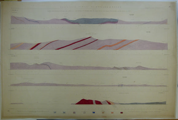


Horizontal Section No. 35 (c1845). From Cwm-cywem, NE of Bala, over Cader Berwyn, the Breidden Hills, the Stiper Stones, Caer Caradoc, Wenlock Edge, Brown Clee Hill. Geological Survey of GB. 1st
Horizontal Section No.35 (n.d. c1845). From Cwm-cywem, North-east of Bala, over Cader Berwyn, the Breidden Hills, the Stiper Stones, Caer Caradoc, Wenlock Edge and the Brown Clee Hill. Geological Survey of GB. 1st edition. Located on Old Series one-inch maps 74nw, sw & se, 60ne. Hand-coloured engraving 69.5 x 102 cm, 1:10,560 scale (6”= 1mile). Flat, linen-taped edge, generally age-toned, slightly soiled. Library stamp on back. In very good condition.
About England & Wales Sections
These hand-coloured engraved ‘horizontal’ sections at six inch to one mile scale were published in the mid 19th century by the Geological Survey of England and Wales. The detailed profiles generally follow the geological dip on the one inch Old Series maps numbered in the upper right hand margin and the profile locations are shown on these maps which themselves did not include a section.