
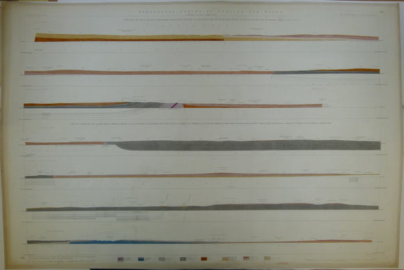


Horizontal Section No. 49 (1858). 1. Barr Beacon, Warwickshire Coalfield, Sutton Park, Kingsbury to Radcliffe Culey. 2. Bodymoor Heath to Donisthorpe, Leicestershire Coalfield to Chellaston Hill. Geological Survey of GB. 2nd.
Horizontal Section No. 49 (1858). 1. From Barr Beacon across the New Red Sandstone, Permian Strata of the Warwickshire Coalfield, through Sutton Park, Kingsbury, Hurley, Baxterley and Merevale to Radcliffe Culey, near Atherstone. 2. From Bodymoor Heath, near Kingsbury, across the Warwickshire Coalfield, through Cliff, Hockley and Wilnecote to Shuttington, across No Man’s Heath, Donisthorpe, the Leicestershire Coalfield, by Moira, Ticknall, to Chellaston Hill, Derbyshire. Geological Survey of GB. 2nd edition. Located on Old Series one-inch maps 62se & ne, 63nw & sw, 71sw. Hand-coloured engraving 67.5 x 100cm, 1:10,560 scale (6”= 1mile). Flat, linen-taped edge, slightly age-toned. Library stamp on back. Coloured 1922. In good to very good condition.
About England & Wales Sections
These hand-coloured engraved ‘horizontal’ sections at six inch to one mile scale were published in the mid 19th century by the Geological Survey of England and Wales. The detailed profiles generally follow the geological dip on the one inch Old Series maps numbered in the upper right hand margin and the profile locations are shown on these maps which themselves did not include a section.