Free UK postage
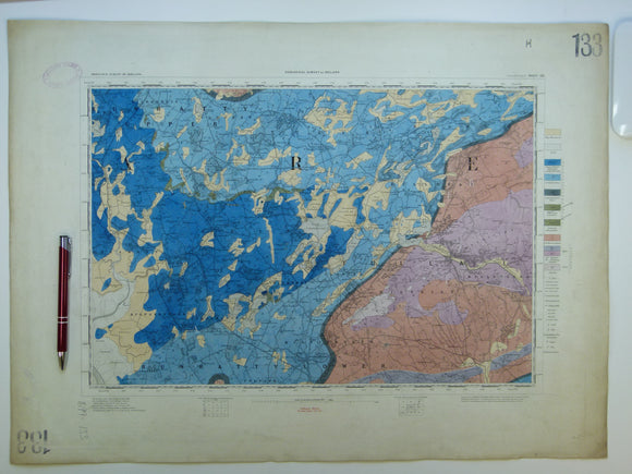
Ireland sheet 133, Sixmilebridge, 1” scale. 1882. Covers Newmarket in Fergus, Tulla. Hand-coloured. Geological Survey of Ireland.
Ireland sheet 133, Sixmilebridge, 1” scale. 1882. Covers Newmarket in Fergus, Tulla. Base map not dated. Coloured 1908. Hand-coloured engraving, flat, 45 x 61.5cm. Bright colours, clean, slightly age-toned. Library...
Regular price £3900 £39.00
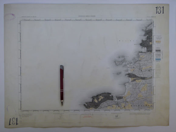
Ireland sheet 131, Mullagh, 1” scale. 1882. Covers Atlantic coast: Donegal Point, Mal Bay – 80% sea. Hand-coloured. Geological Survey of Ireland.
Ireland sheet 131, Mullagh, 1” scale. 1882. Covers Atlantic coast: Donegal Point, Mal Bay – 80% sea. Base map not dated. Hand-coloured engraving, flat, trimmed 42 x 56cm, faint plate...
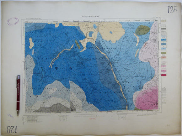
Ireland sheet 128, Athy, 1” scale. 1901. Covers Stradbally. Base map not dated. Coloured 1908. Hand-coloured. Geological Survey of Ireland.
Ireland sheet 128, Athy, 1” scale. 1901. Covers Stradbally. Base map not dated. Coloured 1908. Hand-coloured engraving, flat, 45.5 x 62cm, faint plate mark. Bright colours, clean, slightly age-toned. Library...
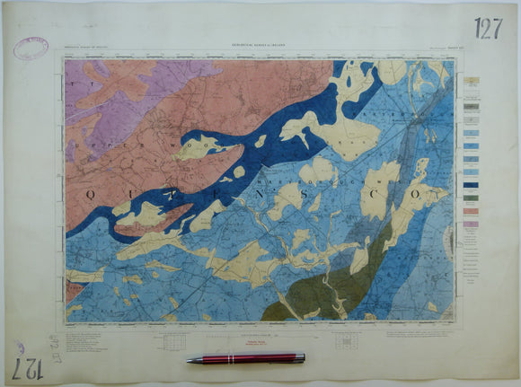
Ireland sheet 127, Maryborough, 1” scale. 1901. Covers Abbeyleix, Mountraith. Hand-coloured. Geological Survey of Ireland.
Ireland sheet 127, Maryborough, 1” scale. 1901. Covers Abbeyleix, Mountraith. Base map not dated. Coloured 1908. Hand-coloured engraving, flat, 43.5 x 60cm, faint plate mark. Bright colours, clean. Library stamps...
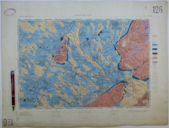
Ireland sheet 126, Roscrea, 1” scale. 1901. Base map not dated. Coloured 1910. Hand-coloured. Geological Survey of Ireland.
Ireland sheet 126, Roscrea, 1” scale. 1901. Base map not dated. Coloured 1910. Hand-coloured engraving, flat, 43.5 x 57.5cm, faint plate mark. Bright colours, slightly soiled. Library stamp in upper...
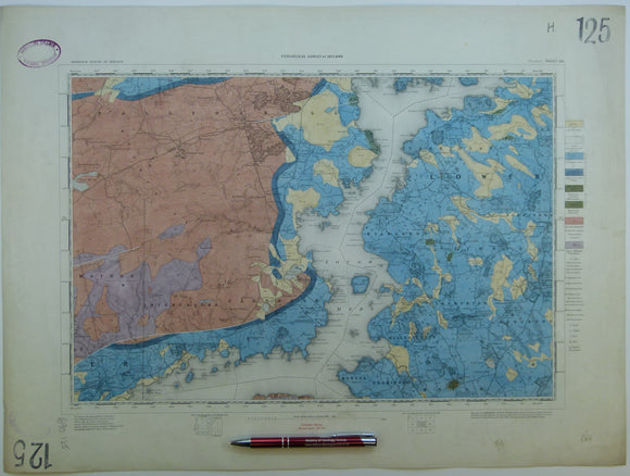
Ireland sheet 125, Woodford, 1” scale. 1901. Covers Lough Derg. Coloured 1904. Hand-coloured. Geological Survey of Ireland.
Ireland sheet 125, Woodford, 1” scale. 1901. Covers Lough Derg. Base map not dated. Coloured 1904. Hand-coloured engraving, flat, 46 x 61.5cm. Bright colours, slightly soiled. Library stamp in upper...
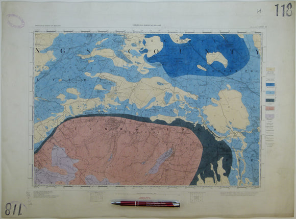
Ireland sheet 118, Mountmellick, 1” scale. 1901. Base map not dated. Coloured 1904. Hand-coloured. Geological Survey of Ireland.
Ireland sheet 118, Mountmellick, 1” scale. 1901. Base map not dated. Coloured 1904. Hand-coloured engraving, flat, 43 x 58.5cm. Bright colours, clean. Library stamps in upper and lower left corners...
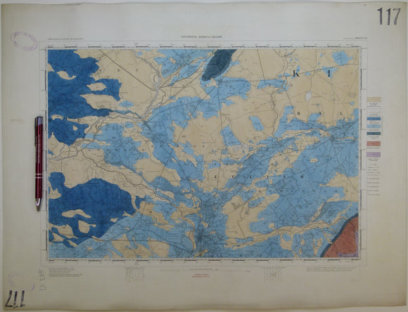
Ireland sheet 117, Parsonstown, 1” scale. 1901. Covers Frankford, Banagher, Cloghan. Hand-coloured. Geological Survey of Ireland.
Ireland sheet 117, Parsonstown, 1” scale. 1901. Base map not dated. Coloured 1904. Covers Frankford, Banagher, Cloghan. Hand-coloured engraving, flat, 44.5 x 58.5cm. Bright colours, clean. Library stamps in upper...
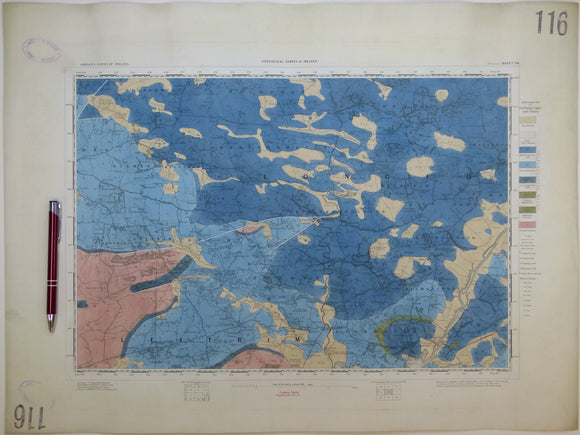
Ireland sheet 116, Portumna, 1” scale. 1863, first edition. Covers Killimore, Eyrecourt. Hand-coloure. Geological Survey of Ireland.
Ireland sheet 116, Portumna, 1” scale. 1863, first edition. Base map not dated. Coloured 1903. Covers Killimore, Eyrecourt. Hand-coloured engraving, flat, 44.5 x 60cm, faint plate mark. Bright colours, slightly...
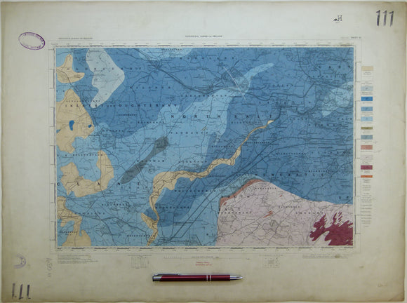
Ireland sheet 111, Maynooth, 1” scale. 1901. Covers Robertstown, Kilcock, Clondalkin. Hand-coloured. Geological Survey of Ireland.
Ireland sheet 111, Maynooth, 1” scale. 1901. Base map not dated. Coloured 1902. Covers Robertstown, Kilcock, Clondalkin. Hand-coloured engraving, flat, 46 x 61.5cm. Bright colours, slightly soiled and age-toned. Library...
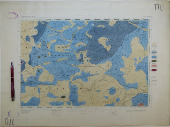
Ireland sheet 110, Edenderry, 1” scale. 1864. First edition. Base map not dated. Hand-coloured engraving,. geo.
Ireland sheet 110, Edenderry, 1” scale. 1864. First edition. Base map not dated. Hand-coloured engraving, flat, 44 x 59.5cm, faint plate mark. Bright colours, slightly age-toned. Library stamps in upper...
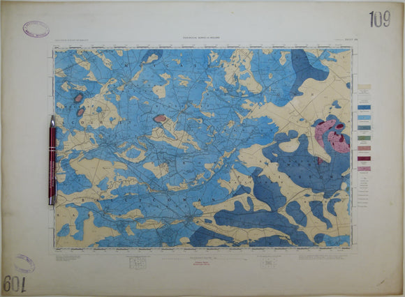
Ireland sheet 109, Tullamore, 1” scale. 1864. First edition. Base map not dated. Covers Clara, Phillipstown. Hand-coloured. Geological Survey of Ireland.
Ireland sheet 109, Tullamore, 1” scale. 1864. First edition. Base map not dated. Covers Clara, Phillipstown. Hand-coloured engraving, flat, 45 x 61.5cm, faint plate mark. Bright colours, slightly age-toned. Library...
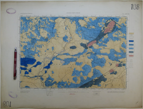
Ireland sheet 108, Athlone, 1” scale. 1865. First edition. Covers Shannonbridge, Moate, Ferrane. Hand-coloured. Geological Survey of Ireland.
Ireland sheet 108, Athlone, 1” scale. 1865. First edition. Base map not dated. Covers Shannonbridge, Moate, Ferrane. Hand-coloured engraving, flat, 45.5 x 60.5cm. Bright colours, slightly age-toned. Library stamps in...
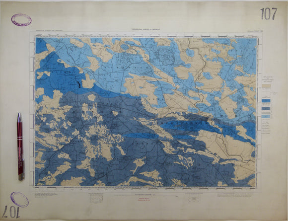
Ireland sheet 107, Ballinasloe, 1” scale. 1867. First edition. Base map not dated. Coloured 1903. Hand-coloured
Ireland sheet 107, Ballinasloe, 1” scale. 1867. First edition. Base map not dated. Coloured 1903. Hand-coloured engraving, flat, 44.5 x 58cm., faint plate mark. Bright colours, slightly age-toned. Library stamps...
Ireland sheet 106, Athenry, 1” scale. 1867, first edition. Oranmore Bay, Monivea. Base map not dated. Hand-coloured. Geological Survey of Ireland.
Ireland sheet 106, Athenry, 1” scale. 1867, first edition. Oranmore Bay, Monivea. Base map not dated. Hand-coloured engraving, flat, 45 x 61cm. faint plate marked Bright colours, slightly age-toned. Library...
Ireland sheet 101, Trim, 1” scale. 1901. Covers Dunboyne. Base map not dated. Coloured 1902. Hand-coloured. Geological Survey of Ireland.
Ireland sheet 101, Trim, 1” scale. 1901. Covers Dunboyne. Base map not dated. Coloured 1902. Hand-coloured engraving, flat, 45 x 60.5cm. Dull colours, very soiled. Library stamp in upper left...
Ireland sheet 98, Ballymahon, 1” scale. 1865. First edition. Lough Ree. Base map not dated. Coloured 1909. Hand-coloured. Geological Survey of Ireland.
Ireland sheet 98, Ballymahon, 1” scale. 1865. First edition. Lough Ree. Base map not dated. Coloured 1909. Hand-coloured engraving, flat, 43 x 60cm. Bright colours, slightly age-toned. Library stamps in...
Ireland sheet 97, Mount Bellew, 1” scale. 1867. First edition. Base map not dated. Coloured 1909. Hand-coloured. Geological Survey of Ireland.
Ireland sheet 97, Mount Bellew, 1” scale. 1867. First edition. Base map not dated. Coloured 1909. Hand-coloured engraving, flat, 45 x 60cm. Bright colours, soiled along top and right edges,...
Ireland sheet 96, Tuam, 1” scale. 1867. First edition. Base map not dated. Coloured 1909. Hand-coloured. Geological Survey of Ireland.
Ireland sheet 96, Tuam, 1” scale. 1867. First edition. Base map not dated. Coloured 1909. Hand-coloured engraving, flat, 43 x 58cm. Bright colours, slightly age-toned. Library stamps in upper and...
Ireland sheet 91, Navan, 1” scale. 1871. Includes River Boyne. Base map not dated. Hand-coloured engraving. Geological Survey of Ireland.
Ireland sheet 91, Navan, 1” scale. 1871. Includes River Boyne. Base map not dated. Hand-coloured engraving, flat, trimmed 41 x 61cm. Bright colours, slightly age-toned. Library stamp in upper left...