
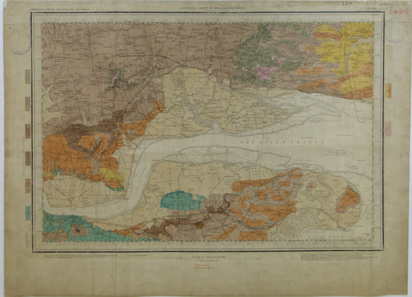
Sheet 1se, drift, Old Series 1". Lowe Thames, Basildon and Southend in Essex, Gravesend in Kent, 1871.
Sheet 1se, drift, Old Series 1". Lowe Thames, Basildon and Southend in Essex, Gravesend in Kent, 1871. issued 1909. Flat, 40 x 54.5cm. Flat, linen-backed, old fold on right map edge. Trimmed without loss of information, slightly dusty but still bright. Small scuff tear near Pitsea, pinholes in corners and bottom margin. Library stamps outside plate mark. drift stamped within plate mark. In fair to good condition.
About the England & Wales One Inch Old Series
The Geological Survey of England and Wales used the Old Series of the Ordnance Survey topographic map at a scale of one inch to the mile as its basemap, initially. These engraved basemaps were published and revised between 1805 and 1885; the sheet sizes varied and the layout and numbering system were eccentric. The Old Series geological maps were hand-coloured and without geological sections, which were published separately. The GS of E&W published the Old Series from 1850 to 1900, when it switched to the colour printing and the New Series one inch maps. However, old stock of the Old Series continued to be issued, hand-coloured, until the 1930s.
See also: Index Map for England & Wales One Inch Old Series.