Free UK postage
Berghaus, Hermann, 1892. Atlas de Geologie; Berghaus Physikalischer Atlas, Abteilung 1. Gotha: Justus Perthes, 7pp+ 15 double page maps. First edition. Justus Perthes.
Berghaus, Hermann, 1892. Atlas de Geologie; Berghaus Physikalischer Atlas, Abteilung 1. Gotha: Justus Perthes, 7pp+ 15 double page maps. First edition. HB, brown cloth-covered embossed boards embossed with gilt lettering...
Regular price £22500 £225.00
Johnston, James FW. (1850). Geological Map of New Brunswick [Canada]. Hand coloured lithographed map,. New Brunswick.
Johnston, James FW. (1850). Geological Map of New Brunswick [Canada]. Hand coloured lithographed map, 49 x 41cm, scale 1”=17 miles / approx. 1:1m. scale. Printed by PS Duval’s Steam Litho...
Regular price £19000 £190.00
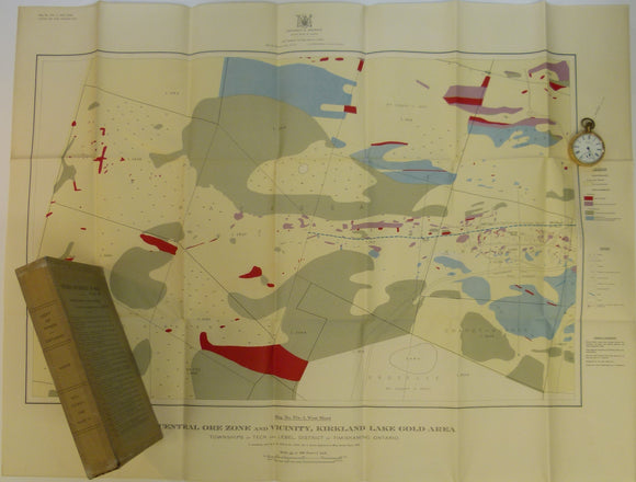
Todd, EW, 1928. Coloured Geological Maps and Sections to accompany Report on Kirkland Lake Gold Area. Dept. of Mines, Ontario
Todd, EW, 1928. Coloured Geological Maps and Sections to accompany Report on Kirkland Lake Gold Area. Dept. of Mines, Ontario, v. XXXVI, pt. 2. Seven folded maps and fifteen folded...
Regular price £13500 £135.00
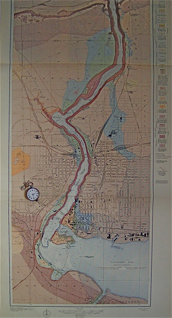
Geologic Atlas of the US: Niagara Folio, New York, 1913. USGS New York.
Geologic Atlas of the US: Niagara Folio, New York, 1913. Large paper back folio, 21.75"x 18.5" comprising 24pp of text with figures, 3 maps on the Niagara Quadrangle, 1:125,000 scale...
Regular price £7900 £79.00
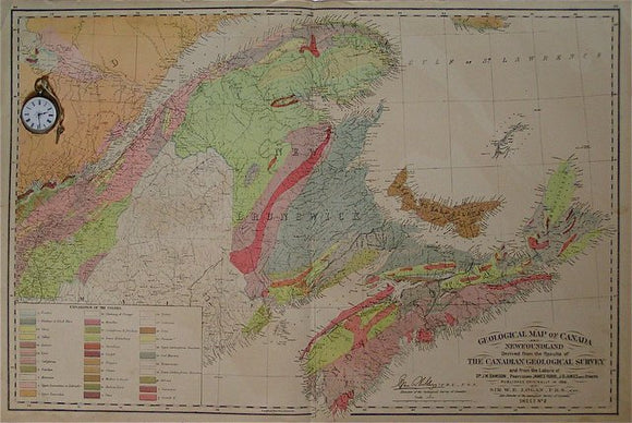
Geological Map of Canada and Newfoundland sheet 2. Dawson et al.
Geological Map of Canada and Newfoundland sheet 2, covering New Brunswick, Nova Scotia and adjacent Quebec, 1881. Scale 1:1,584,000. Colour print, 44.5x68cm. Title block states "originally printed 1865", facsimile signature...
Greenland (c1970).Tectonic/Geological Map of Greenland. Copenhagen: Geological Survey of Greenland, 1:2,500,000 scale. 114 x 85 cm. Geological Survey of Greenland.
Greenland (c1970).Tectonic/Geological Map of Greenland. Copenhagen: Geological Survey of Greenland, 1:2,500,000 scale. 114 x 85 cm. Linen-backed colour print, single centre fold. Bright and clean apart library stamps in lower...
Regular price £5500 £55.00
Greenland (c1970).Quaternary Map of Greenland. Copenhagen: Geological Survey of Greenland, 1:2,500,000 scale. 112 x 83cm. Linen-backed colour print
Greenland (c1970).Quaternary Map of Greenland. Copenhagen: Geological Survey of Greenland, 1:2,500,000 scale. 112 x 83cm. Linen-backed colour print, single centre fold. Bright and clean apart library stamps in lower right...
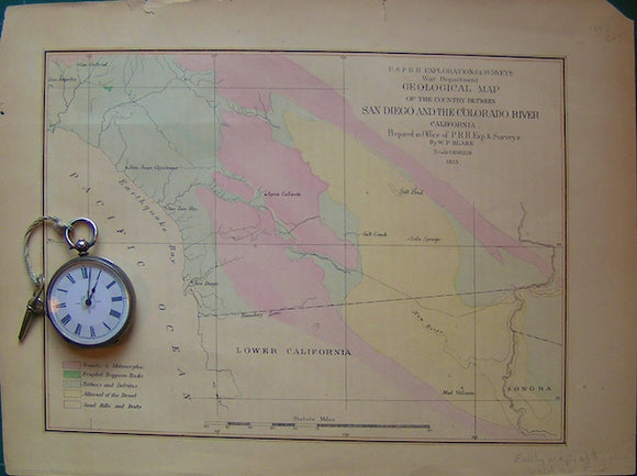
Geological Map of the country between San Diego and the Colorado River. California.
Geological Map of the country between San Diego and the Colorado River, California . USPRR Explorations and Surveys, War Dept. by WP Blake. 1:608,228 but graphic scale is ca 1"=...
Regular price £3900 £39.00
Labrador (c1971).Geological Map of Labrador. 1:1,000,000 scale, 115 x 107cm. Colour lithograph dissected into two parts and mounted on linen
Labrador (c1971).Geological Map of Labrador. Mineral Resources Division, Dept of Mines, Agriculture and Resources, Province of Newfoundland and Labrador. 1:1,000,000 scale, 115 x 107cm. Colour lithograph dissected into two parts...
Regular price £3500 £35.00
Ussing, N.V. (1911). Geology of the Country Around Julianehaab, Greenland. Reprint from Meddelelser om Grønland. v.38. Copenhagen:. U of Copenhagen.
Ussing, N.V. (1911). Geology of the Country Around Julianehaab, Greenland. Reprint from Meddelelser om Grønland. v.38. Copenhagen: Bianco Luno, 368 + vii pp. + 6 foldout maps and sections +...
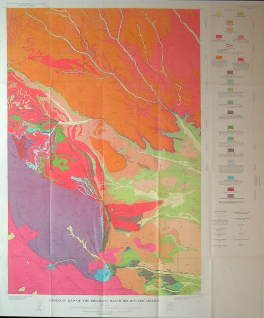
Geologic Map of the Philmont Ranch Region, 1964. New Mexico.
Geologic Map of the Philmont Ranch Region, 1964, from USGS professional paper 505. Plate 3. Scale 1:48,000. Folded colour print, 37.5"x30". Clean bright and in very good condition. Part of...
Regular price £2900 £29.00
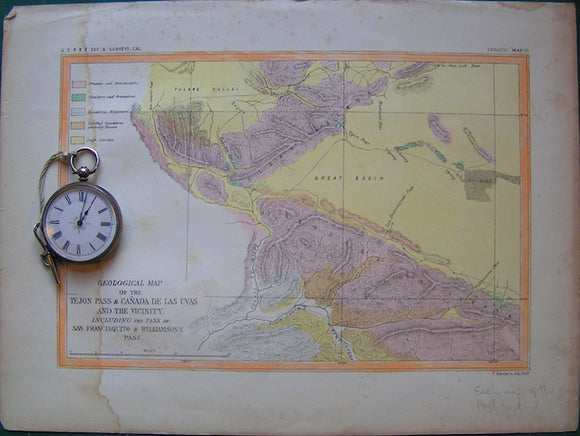
Geological Map of the Tejon Pas and Ca?ada de las Uvas and Vicinity. California.
Geological Map of the Tejon Pas and Ca?ada de las Uvas and Vicinity. Ca 1855. Including the pass of San Francisquito and Williamsons Pass. USPRR Explorations and Surveys, War Dept....
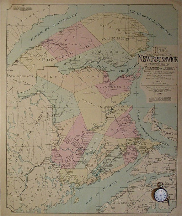
Map of the Province of New Brunswick and Eastern part (Gaspe Peninsula) of the Province of Quebec showing cities, towns and villages of population 400 or more, also Counties & Townships and Railways with Location of Stations, etc, …. Goad, Charles.
Map of the Province of New Brunswick and Eastern part (Gaspe Peninsula) of the Province of Quebec showing cities, towns and villages of population 400 or more, also Counties &...
Maclure, William (1817). Observations on the Geology of the United States of America; A 1962 REPRODUCTION. Werner Fritsch.
Maclure, William (1817). Observations on the Geology of the United States of America; with Some Remarks on the Effect Produced on the Nature and Fertility of Soils, by the Decomposition...
Regular price £2600 £26.00
Gesner, A. (1845). ‘Geological Map of Nova Scotia’ accompanying Dawson, J.W. ‘On the Lower Carboniferous Rocks, . . . of Nova Scotia’ extract from QJGS. Geological Society of London.
Gesner, A. (1845). ‘Geological Map of Nova Scotia’ accompanying Dawson, J.W. ‘On the Lower Carboniferous Rocks, or Gypsiferous Formation of Nova Scotia’ extract from Quarterly Journal of the Geological Society,...
Regular price £2400 £24.00
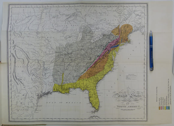
Owen, D. Dale (1846). ‘Geological Chart of the Ohio Valley to accompany Dr. Dale Owen’s Paper’ in ‘On the Geology of the Western States of North America’, extract from QJGS. Geological Society of London.
Owen, David Dale (1846). ‘Geological Chart of the Ohio Valley to accompany Dr. Dale Owen’s Paper’ in ‘On the Geology of the Western States of North America’, extract from Quarterly...
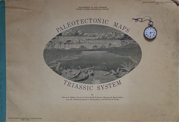
Paleotectonic Maps – Triassic System, Miscellaneous Geologic Investigations I-300, 1959. USGS, McKee, ED et al.
Paleotectonic Maps – Triassic System, Miscellaneous Geologic Investigations I-300, 1959. Soft-cover atlas, 15"x22", comprising 33 pp text, single-sided printing, and large fold out maps (30"x42") at various scales, showing geologic...
Regular price £1600 £16.00
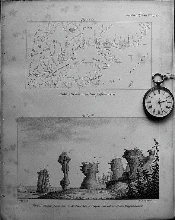
Sketch of the River and Gulf of St.Lawrence, 1833. Bayfield, TGS.
Sketch of the River and Gulf of St.Lawrence, 1833, not to scale, 3.5"x6.5" on same page as engraved illustration of Natural Columns of Limestone on the East Side of Niapisca...
Hess, H.H. (1960). Stillwater Igneous Complex, Montana; a Quantitative Mineralogical Study. Geological Society of America Memoir 80,. Geological Society of America.
Hess, H.H. (1960). Stillwater Igneous Complex, Montana; a Quantitative Mineralogical Study. Geological Society of America Memoir 80, New York: GSA, 1st edition, xiii + 230pp. + map and 7 graphs...
Regular price £1500 £15.00
Taylor, R.B. (1964). Geology of the Duluth Gabbro Complex near Duluth, Minnesota. Minneapolis, Minnesota, 1st edition. Minnesota University Presss.
Taylor, R.B. (1964). Geology of the Duluth Gabbro Complex near Duluth, Minnesota. Minneapolis, Minnesota University Press, 1st edition, x + 63pp. + map in pocket. Hardback, maroon cloth-covered boards, with...


![Johnston, James FW. (1850). Geological Map of New Brunswick [Canada]. Hand coloured lithographed map,](http://geolmaps.com/cdn/shop/products/JohnstonsNewBrunswick1850_{width}x.jpg?v=1617639428)
![Johnston, James FW. (1850). Geological Map of New Brunswick [Canada]. Hand coloured lithographed map,](http://geolmaps.com/cdn/shop/products/JohnstonsNewBrunswick1850_580x.jpg?v=1617639428)