Free UK postage
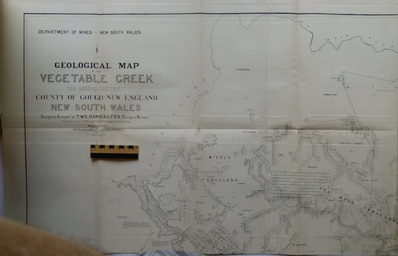
Geological Map of the Vegetable Creek Tin Mining Field, Gough County, New England District, New South Wales 1885. David, TW Edgeworth.
Geological Map of the Vegetable Creek Tin Mining Field, Gough County, New England District, New South Wales 1885, (dom) in Geology of the Vegetable Creek Tin-Mining Field, New England District,...
Regular price £35000 £350.00
Berghaus, Hermann, 1892. Atlas de Geologie; Berghaus Physikalischer Atlas, Abteilung 1. Gotha: Justus Perthes, 7pp+ 15 double page maps. First edition. Justus Perthes.
Berghaus, Hermann, 1892. Atlas de Geologie; Berghaus Physikalischer Atlas, Abteilung 1. Gotha: Justus Perthes, 7pp+ 15 double page maps. First edition. HB, brown cloth-covered embossed boards embossed with gilt lettering...
Regular price £22500 £225.00
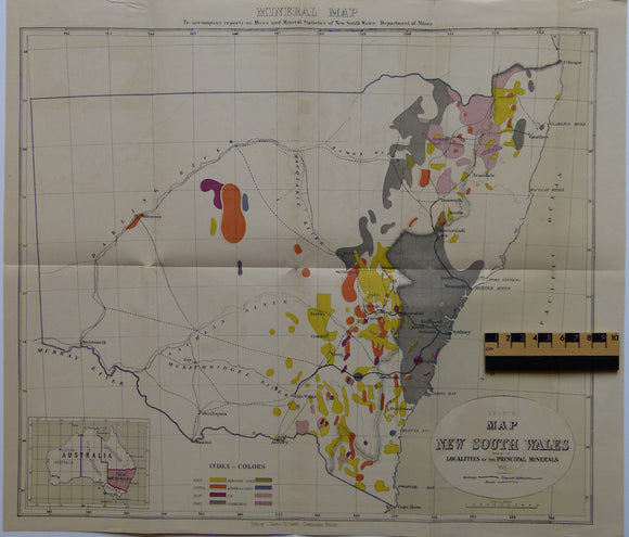
Sketch Map of New South Wales shewing the Localities of the Principal Minerals. NSW Dept of Mines.
Sketch Map of New South Wales shewing the Localities of the Principal Minerals, colour printed, 40 x 46.5cm (15.75 x 18.5 in) in Mines and Mineral Statistics of New South...
Regular price £13000 £130.00
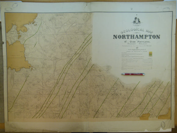
Western Australia, Geological Map of Northampton, 1898. By Gov’t geologist, A.Gibb Maitland. 1:15,840. Geological Survey of Western Australia.
Western Australia, Geological Map of Northampton, 1898. By Gov’t geologist, A.Gibb Maitland. 1:15,840 (1” =20 chains = .25 mile), 77 x 102cm. Northampton is located approx. 500km north of Perth....
Regular price £5500 £55.00
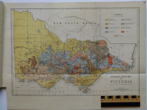
Geological Sketch Map of Victoria, 1895. Murray, Reginald AF.
Geological Sketch Map of Victoria, 1895. In Victoria: Geology and Physical Geography, Dept of Mines. Colour print, 1:2,534,400 (1in = 40 miles) 27.5 x 35.5cm (10.75 x 14 in), folded,...
Regular price £5400 £54.00
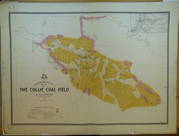
Western Australia, Geological Map of the Collie Coal Field, 1898. By Gov’t geologist, A.Gibb Maitland. 1:31,680. Geological Survey of Western Australia.
Western Australia, Geological Map of the Collie Coal Field, 1898. By Gov’t geologist, A.Gibb Maitland. 1:31,680 (1”=40 chains = .5 mile), Colour printed, 77 x 102cm. The Collie valley is...
Regular price £4500 £45.00
Sandhurst Gold Field [Victoria] (1878). Ministry of Mines. 1:31,680 scale. Colour lithograph, 63 x 88 cm, originally named Bendigo. Victoria Ministry of Mines.
Sandhurst Gold Field [Victoria] (1878). Ministry of Mines. 1:31,680 scale. Colour lithograph 63 x 88 cm, dissected and mounted on linen, 91.5 x 56.5 cm with single centre fold. Originally...
Regular price £3500 £35.00
Sketch Map of East Central Queensland; Gold, Mineral and Coalfields Between Rockhampton, Gladstone and the Dawson and Mackenzie Rivers. Brisbane. Queensland Dept of Mines.
Sketch Map of East Central Queensland; Gold, Mineral and Coalfields Between Rockhampton, Gladstone and the Dawson and Mackenzie Rivers. Brisbane: Dept of Mines. Colour lithograph 1:253,440 scale, 99.5 x 75.5cm...
Regular price £3000 £30.00
Woodroffe, Sheet SG 52-12, zone 5, 1967, scale 1:250,000.
Woodroffe, Sheet SG 52-12, zone 5, 1967, scale 1:250,000. Colour print, 27"x36", folded. In good condition.
Regular price £800 £8.00
Oodnadatta, Sheet SG 53-15, zone 5, 1967, scale 1:250,000.
Oodnadatta, Sheet SG 53-15, zone 5, 1967, scale 1:250,000. Colour print, 27"x36", folded. In good condition.
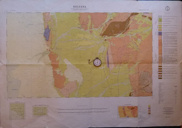
Beltana, SA. Sheet 696, zone 5, 1966, scale 1:63,360.
Beltana, SA. Sheet 696, zone 5, 1966, scale 1:63,360. Colour print, 26”x38”, folded. In good condition.
Dubbo, sheet SI 55-4, 1968, scale 1:250,000 Colour print 27"x40", folded, wear on folds, in Fair to Good…
Dubbo, sheet SI 55-4, 1968, scale 1:250,000 Colour print 27"x40", folded, wear on folds, in Fair to Good condition.
Regular price £700 £7.00
Bathurst, sheet SI 55-8, 1966, scale 1:250,000 Colour print 27"x40", folded, wear on folds, in Fair to…
Bathurst, sheet SI 55-8, 1966, scale 1:250,000 Colour print 27"x40", folded, wear on folds, in Fair to Good condition.
New South Wales, Geological Map of, 1962, scale 1:1,000,000.
New South Wales, Geological Map of, 1962, scale 1:1,000,000. Colour print on two sheets, each 45"x29", on light paper with single fold. In good condition.
Regular price £500 £5.00


![Sandhurst Gold Field [Victoria] (1878). Ministry of Mines. 1:31,680 scale. Colour lithograph, 63 x 88 cm, originally named Bendigo](http://geolmaps.com/cdn/shop/files/SandhurstAus_1_{width}x.jpg?v=1781694256)
![Sandhurst Gold Field [Victoria] (1878). Ministry of Mines. 1:31,680 scale. Colour lithograph, 63 x 88 cm, originally named Bendigo](http://geolmaps.com/cdn/shop/files/SandhurstAus_1_580x.jpg?v=1781694256)