Free UK postage
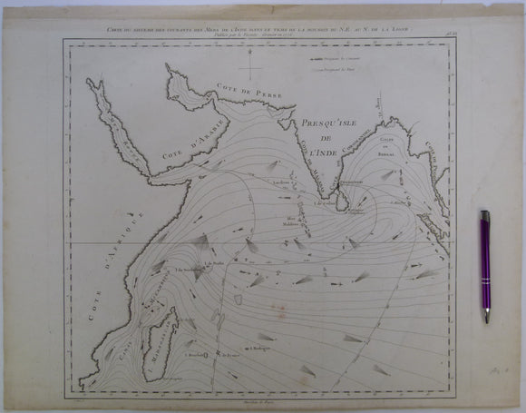
Indian Ocean. Grenier, Jacques-Raymond de (1776). Carte du Sisteme des Courantes des Mers de l’Inde dans le Tems de la Mousson du NE au N. de la Ligne. Paris: Lattré. Lattre.
Indian Ocean. Grenier, Jacques-Raymond de (1776). Carte du Sisteme des Courantes des Mers de l’Inde dans le Tems de la Mousson du NE au N. de la Ligne. Paris: Lattré....
Regular price £35000 £350.00
Berghaus, Hermann, 1892. Atlas de Geologie; Berghaus Physikalischer Atlas, Abteilung 1. Gotha: Justus Perthes, 7pp+ 15 double page maps. First edition. Justus Perthes.
Berghaus, Hermann, 1892. Atlas de Geologie; Berghaus Physikalischer Atlas, Abteilung 1. Gotha: Justus Perthes, 7pp+ 15 double page maps. First edition. HB, brown cloth-covered embossed boards embossed with gilt lettering...
Regular price £22500 £225.00
Nepal and Tibet. Bordet, P. and Latreille, M. (1955). ‘La Géologie de l’Himalaya de l’Arun’, offprint of Bulletin de la Société Géologique de France,. Societe Geologique de France.
Nepal and Tibet. Bordet, P. and Latreille, M. (1955). ‘La Géologie de l’Himalaya de l’Arun’, offprint of Bulletin de la Société Géologique de France, vol. 5, pp.529-542, together in printed...
Regular price £9500 £95.00
India. Sinha, Anshu K. (1989). Geology of the Higher Central Himalaya. Chichester: John Wiley and Sons. 1st edition, xiv + 219pp. Hardback. John Wiley.
India. Sinha, Anshu K. (1989). Geology of the Higher Central Himalaya. Chichester: John Wiley and Sons. 1st edition, xiv + 219pp. Hardback laminated board cover in matching slip case together with three...
Regular price £7500 £75.00
Myanmar. (1874). ‘Geological Map of Pegu Province, British Burmah’, extract of The Memoirs of the Geological Survey of India, vol. 10. Colour printed map. Geological Survey of India.
Myanmar. (1874). ‘Geological Map of Pegu Province, British Burmah’, extract of The Memoirs of the Geological Survey of India, vol. 10. Colour printed map 1:506,889 scale, 94 x 85cm folded...
Regular price £4500 £45.00
Pakistan. (1958). Reconnaissance Geology of Part of West Pakistan. Set of 3 maps north of Karachi: No. 6, Thano Bula Khan 35 K-O, Bela 35 J-N, and Khuzdar 35 I-M. Gov't of Canada.
Pakistan. (1958). Reconnaissance Geology of Part of West Pakistan. Set of 3 maps north of Karachi: No. 6, Thano Bula Khan 35 K-O, Bela 35 J-N, and Khuzdar 35 I-M....
India and Bangladesh. Pascoe, E.H. (1914). ‘The Petroleum Occurrences of Assam and Bengal’, comprising all of volume of 40 of Memoirs of the Geological Survey of India. Geological Survey of India.
India and Bangladesh. Pascoe, E.H. (1914). ‘The Petroleum Occurrences of Assam and Bengal’, comprising the all of volume 40 of Memoirs of the Geological Survey of India. Calcutta: GSI, v.40, part...
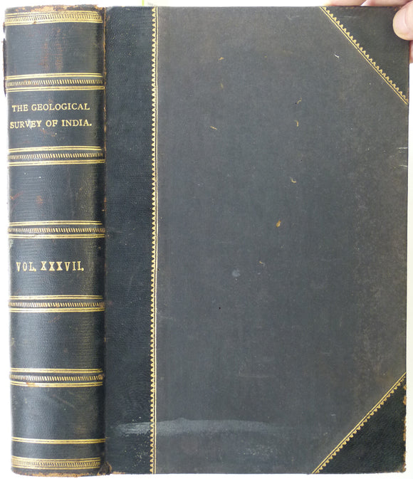
India. Fermor, L. Leigh (1909). ‘The Manganese Ore Deposits of India’ comprising all of volume 37 of Memoirs of the Geological Survey of India. Geological Survey of India.
India. Fermor, L. Leigh (1909). ‘The Manganese Ore Deposits of India’ comprising all of volume 37 of Memoirs of the Geological Survey of India. Calcutta: GSI, v.37, part 4, pp. 612-1294...
Myanmar. Cotter, G.de P. (1938). ‘The Geology of Parts of the Minbu, Myingyan, Pakokku and Lower Chindwin Districts, [Mandalay region] Burma’ in Memoirs of the G S of India,. Geological Survey of India.
Myanmar. Cotter, G.de P. (1938). ‘The Geology of Parts of the Minbu, Myingyan, Pakokku and Lower Chindwin Districts, [Mandalay region] Burma’ in Memoirs of the Geological Survey of India, v.72,...
India. Geological Map of Parts of Bundeland and Bogheland and of the Districts of Saugor [Sagar] and Jubulpore [Jabalpur], (1829), Upper Ganges River. Upper Ganges R.
India. Geological Map of Parts of Bundeland and Bogheland and of the Districts of Saugor [Sagar] and Jubulpore [Jabalpur], by Capt'n James Franklin, FGS, Trans.Geol.Soc, 2nd Series, v3, pl35, 1829....
Regular price £3900 £39.00
Thailand. Geological Map of Thailand (1969). Bangkok: Dept. of Mineral Resources. Folded colour-printed maps, north and south sheets neatly joined, 1:1,000,000. Thai Mineral Resources.
Thailand. Geological Map of Thailand (1969). Bangkok: Dept. of Mineral Resources. Folded colour-printed maps, north and south sheets neatly joined, 1:1,000,000, 185 x 104cm folding to 35 x 26cm. Clean,...
Regular price £3500 £35.00
India. Hughes, T.W.H. (1877) ‘The Wardha Valley Coal-Field [Maharashtra State]’ and Geology of the Rajmehal Hills [West Bengal state]’ Memoirs of the Geological Survey of India, v.13,. Geological Survey of India.
India. Hughes, T.W.H. (1877) ‘The Wardha Valley Coal-Field [Maharashtra State]’ in Memoirs of the Geological Survey of India, v.13, pt.1, pp1-154 + 3 folding maps, bound together with part 2,...
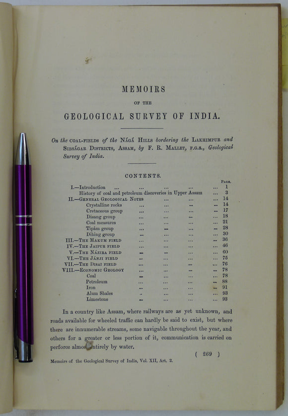
India / Myanmar. Mallet, F.R. (1876). ‘On the Coal-fields of the Naga Hills Bordering the Lakhimpur and Sisagar Districts’, extract of The Memoirs. Geological Survey of India.
India / Myanmar. Mallet, F.R. (1876). ‘On the Coal-fields of the Naga Hills Bordering the Lakhimpur and Sisagar Districts’, extract of The Memoirs of the Geological Survey of India, vol....
Regular price £2800 £28.00
Southeast Asia. Geological Map of Viet Nam. (1986). UN (ESCAP) in Cooperation with General Dept of Mines and Geology of Viet Nam. Folded colour printed map, 1:1,500,000,. United Nations.
Southeast Asia. Geological Map of Viet Nam. (1986). UN Economic & Social Commission for Asia & the Pacific (ESCAP) in Cooperation with the General Dept of Mines and Geology of...
Regular price £2500 £25.00
Subbarao, K.V. and Sukheswala, R.N. (eds) (1982). Deccan Volcanism and Related Basalt Provinces in other parts of the World. Bangalore: Geological Society of India. Geological Society of India.
Subbarao, K.V. and Sukheswala, R.N. (eds) (1982). Deccan Volcanism and Related Basalt Provinces in other parts of the World. Bangalore: Geological Society of India Memoir No.3, 1st edition, 474pp. Hardback,...
Regular price £2200 £22.00
Iran. Masjid-I-Sulaiman Road Map (1954). A.I.O.C. [Anglo-Iranian Oil Company] 1:21,120 scale. Folded linen-backed paper (65 x 100cm), 3 colour linework. NOT GEOLOGICAL. Anglo-Iranian Oil Co.
Iran. Masjid-I-Sulaiman Road Map (1954). A.I.O.C. [Anglo-Iranian Oil Company] 1:21,120 scale. Folded linen-backed paper (65 x 100cm), 3 colour linework. NOT GEOLOGICAL. Folding is not neat, creased in centre, age-toned,...
Regular price £2000 £20.00
Kazmi, Ali H., and Rana, Riaz A. (compilers) (1982). Tectonic Map of Pakistan. Karachi: Geological Survey of Pakistan. 1st edition. Folded colour-printed map. Geological Survey of Pakistan.
Kazmi, Ali H., and Rana, Riaz A. (compilers) (1982). Tectonic Map of Pakistan. Karachi: Geological Survey of Pakistan. 1st edition. Folded colour-printed map, 1:2,000,000, 78 x 98cm, with several small...
Tahirkheli, RA Khan. (1982). Geology of the Himalaya, Karakoram and Hindukush in Pakistan. Peshawar: University of. 1st edition. University of Peshawar.
Tahirkheli, RA Khan. (1982). Geology of the Himalaya, Karakoram and Hindukush in Pakistan. Peshawar: University of. 1st edition. Special edition of v.15 of Geological Bulletin of the University of Peshawar....
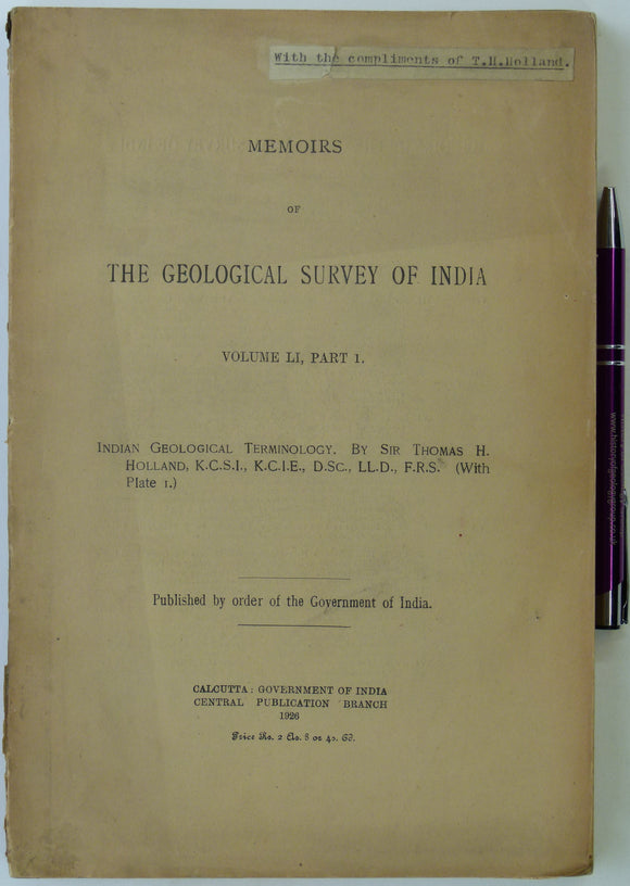
India. Holland, Thomas H. (1926). Indian Geological Terminology; Memoirs of the Geological Survey of India. Geological Survey of India.
India. Holland, Thomas H. (1926). Indian Geological Terminology; Memoirs of the Geological Survey of India, vol. 51, pt.1, pp.ii (preface) + 184 + xx (indices) + one foldout b/w ‘Index...
Southeast Asia. Indo-Chine, Carte de la Mission Pavie. (1921). Paris: Ministre des Affaires Etrangeres sous le direction de M.Pavie. NOT GEOLOGICAL. Folded, colour. French colonial.
Southeast Asia. Indo-Chine, Carte de la Mission Pavie. (1921). Paris: Ministre des Affaires Etrangeres et du Ministre des Colonies, sous le direction de M.Pavie. 1:2,000,000. (66 x 78cm). NOT GEOLOGICAL....
Regular price £1800 £18.00


![Myanmar. Cotter, G.de P. (1938). ‘The Geology of Parts of the Minbu, Myingyan, Pakokku and Lower Chindwin Districts, [Mandalay region] Burma’ in <em>Memoirs of the G S of India</em>,](http://geolmaps.com/cdn/shop/files/India_57_MemGSI72_{width}x.jpg?v=1709635905)
![Myanmar. Cotter, G.de P. (1938). ‘The Geology of Parts of the Minbu, Myingyan, Pakokku and Lower Chindwin Districts, [Mandalay region] Burma’ in <em>Memoirs of the G S of India</em>,](http://geolmaps.com/cdn/shop/files/India_57_MemGSI72_580x.jpg?v=1709635905)
![India. Geological Map of Parts of Bundeland and Bogheland and of the Districts of Saugor [Sagar] and Jubulpore [Jabalpur], (1829), Upper Ganges River](http://geolmaps.com/cdn/shop/products/india-upperganges_{width}x.jpg?v=1522955082)
![India. Geological Map of Parts of Bundeland and Bogheland and of the Districts of Saugor [Sagar] and Jubulpore [Jabalpur], (1829), Upper Ganges River](http://geolmaps.com/cdn/shop/products/india-upperganges_580x.jpg?v=1522955082)


![India. Hughes, T.W.H. (1877) ‘The Wardha Valley Coal-Field [Maharashtra State]’ and Geology of the Rajmehal Hills [West Bengal state]’ <em>Memoirs of the Geological Survey of India</em>, v.13,](http://geolmaps.com/cdn/shop/files/India_60_MemGSI13_{width}x.jpg?v=1709635309)
![India. Hughes, T.W.H. (1877) ‘The Wardha Valley Coal-Field [Maharashtra State]’ and Geology of the Rajmehal Hills [West Bengal state]’ <em>Memoirs of the Geological Survey of India</em>, v.13,](http://geolmaps.com/cdn/shop/files/India_60_MemGSI13_580x.jpg?v=1709635309)


![Iran. Masjid-I-Sulaiman Road Map (1954). A.I.O.C. [Anglo-Iranian Oil Company] 1:21,120 scale. Folded linen-backed paper (65 x 100cm), 3 colour linework. NOT GEOLOGICAL.](http://geolmaps.com/cdn/shop/files/Asia_13_Masjid_{width}x.jpg?v=1741886934)
![Iran. Masjid-I-Sulaiman Road Map (1954). A.I.O.C. [Anglo-Iranian Oil Company] 1:21,120 scale. Folded linen-backed paper (65 x 100cm), 3 colour linework. NOT GEOLOGICAL.](http://geolmaps.com/cdn/shop/files/Asia_13_Masjid_580x.jpg?v=1741886934)