Free UK postage
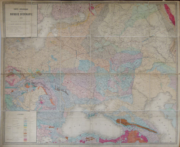
Carte Geologique de la Russie d’Europe, 1859. Approx 1:3,675,000 scale. (77 x 93.5cm) hand-coloured engraved map. Jules Guillemin.
Carte Geologique de la Russie d’Europe, 1859. Approx 1:3,675,000 scale. (77 x 93.5cm) hand-coloured engraved map by E. Andriveau-Goujon, Paris. Originally folded, then dissected and mounted on linen to fold....
Regular price £1,20000 £1,200.00
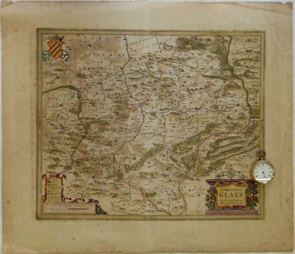
Poland. 1639. Comitatus Glatz. Authore Iona Sculteto. Henricus Hondius execudit, Amsterdam. Hand coloured engraving at 1:100,000 approx
Poland. 1639. Comitatus Glatz. Authore Iona Sculteto. Henricus Hondius execudit, Amsterdam. Hand coloured engraving at 1:100,000 approx. (4cm = 1 Millaria Germanica Communia). Glatz is now called Klodzko and is...
Regular price £20000 £200.00
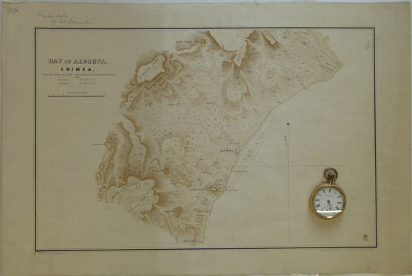
Ukraine / Russia. 1855. Bay of Alushta, Crimea; from the Survey by Captn. E. Manganari of the Russian Imperial Navy
Ukraine / Russia. 1855. Bay of Alushta, Crimea; from the Survey by Captn. E. Manganari of the Russian Imperial Navy 1836. Topographic map with offshore contours. Not geological. 1:63,360 scale...
Regular price £5000 £50.00
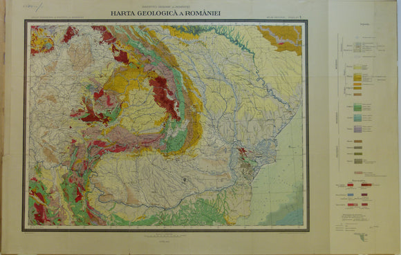
Romania. 1926. Carte Geologique de la Roumaine. Colour printed map 1:1,500,000 scale (52 x 81cm)
Romania. 1926. Carte Geologique de la Roumaine. Colour printed map 1:1,500,000 scale (52 x 81cm). printed by Berliner Lithographisches Institut. sheet 1 of Geological Atlas, sold separately. Includes adjacent parts...
Regular price £4000 £40.00
Kozák, Jan; Čejchanová, Alena; Kukal, Zdeněk; Pošmourný, Karel (eds). (2016). Early Geological Maps of Europe; Central Europe 1750-1840. Springer. . Springer.
Kozák, Jan; Čejchanová, Alena; Kukal, Zdeněk; Pošmourný, Karel (eds). (2016). Early Geological Maps of Europe; Central Europe 1750-1840. Springer. xiii + 155pp. Hardback. Illustrated cover. A4 format. In new condition....
Regular price £3500 £35.00
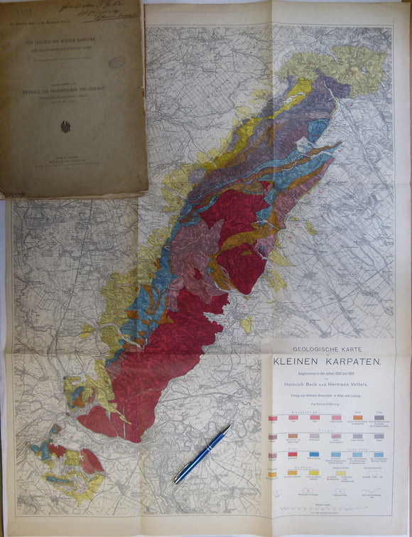
Beck, Heinrich, and Vetters, Hermann. (1904). ‘Geologische Karte der Kleinen Karpaten’, 1:75,000 scale, 91 x 69cm, colour printed and folding to 33 x 24cm. Wilhelm Braumuller.
Beck, Heinrich, and Vetters, Hermann. (1904). ‘Geologische Karte der Kleinen Karpaten’, 1:75,000 scale, 91 x 69cm, colour printed and folding to 33 x 24cm. Age-toned, but clean, no tears. In...
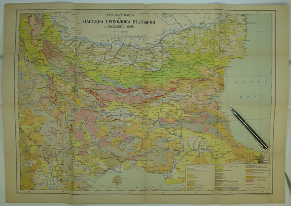
Bulgaria (c.1950). Geological Map of Bulgaria. 1:1,000,000 scale. Colour printed folded map, 50 x 70cm. Bulgarian Geological Survey.
Bulgaria (c.1950). Geological Map of Bulgaria. 1:1,000,000 scale. Colour printed folded map, 50 x 70cm. Age-toned with wear along folds and ‘pin-hole’ at intersection of outside folds. No date given...
Regular price £2200 £22.00
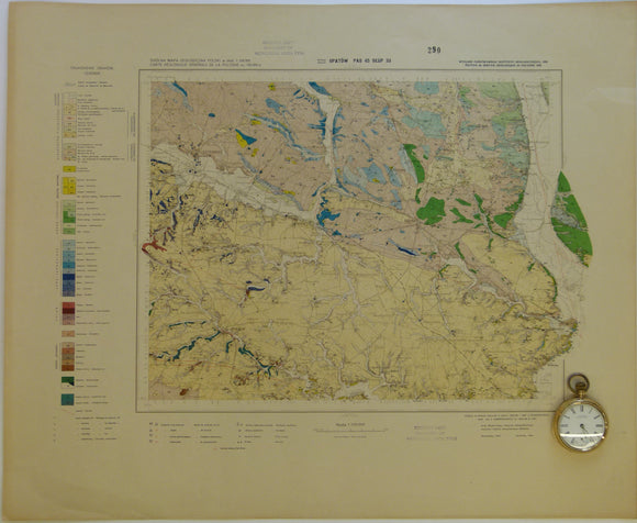
Poland. 1938. Opatów, no sheet number (pas 45, słup33) of Carte Géologique Générale de la Pologne. Colour printed map
Poland. 1938. Opatów, no sheet number (pas 45, słup33) of Carte Géologique Générale de la Pologne. Colour printed map at 1:100,000 scale (45.5 x 55.5cm). Age-toned, slightly soiled, clean and...
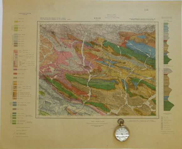
Poland. 1938. Kielce, Sheet 4 (pas 46, słup31) of Carte Géologique Générale de la Pologne. Colour printed map
Poland. 1938. Kielce, Sheet 4 (pas 46, słup31) of Carte Géologique Générale de la Pologne. Colour printed map at 1:100,000 scale (45 x 54.5cm). Age-toned, slightly soiled, library stamps, clean...
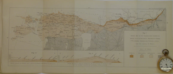
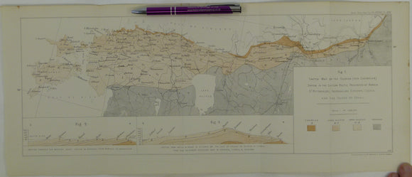
Judd, JW, (1876). ‘On the Ancient Volcano of the District of Schemnitz, Hungary [now Slovakia]’, extract from the Quarterly Journal of the Geological Society, v32,. Geological Society of London.
Judd, JW, (1876). ‘On the Ancient Volcano of the District of Schemnitz, Hungary [now Slovakia]’, extract from the Quarterly Journal of the Geological Society, v32, pp.292-325. With colour printed fold-out map '[Geological]...
Regular price £1800 £18.00
Poland. 1984. Mapa Geologiczna Polski I Krajow Osciennych; bez utworow kenozoicznych, mesosoicznych i permskich. [Geological Map of Poland and Adjoining Countries without Cenozoic, Mesozoic and Permian formations] Set of 3 maps
Poland. 1984. Mapa Geologiczna Polski I Krajow Osciennych; bez utworow kenozoicznych, mesosoicznych i permskich. [Geological Map of Poland and Adjoining Countries without Cenozoic, Mesozoic and Permian formations] Set of 3...
Regular price £1600 £16.00
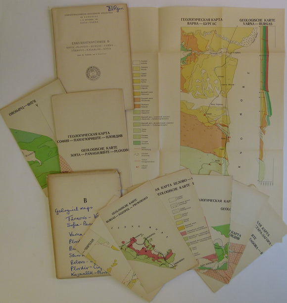
Bulgaria.1965. Dimitrov, C. Exkursionsfuhrer B - Sofia – Plovdiv – Burgas – Varna – Tarnovo – Kasanlak – Sofia.
Bulgaria.1965. Dimitrov, C. Exkursionsfuhrer B - Sofia – Plovdiv – Burgas – Varna – Tarnovo – Kasanlak – Sofia. Set of nine colour printed folded geological maps at 1:200,000 scale...
Schmidt, F. (1882). 'Sketch Map of the Silurian (and Cambrian) System in the Eastern Baltic Provinces of Russia –. Geological Society of London.
Schmidt, F. (1882). 'Sketch Map of the Silurian (and Cambrian) System in the Eastern Baltic Provinces of Russia – St.Petersburg, Ingermanland, Esthonia, Livonia, and the Island of Oesel, in ‘On...
Regular price £1400 £14.00
Bulgaria. 1965. Boncev Ek. & Dimitrov, C. Exkursionsfuhrer Sofia [A] – Belogradcik – Sofia.
Bulgaria. 1965. Boncev Ek. & Dimitrov, C. Exkursionsfuhrer Sofia [A] – Belogradcik – Sofia. Set of four colour printed folded geological maps at 1:200,000 scale in original envelope, with guidebook...
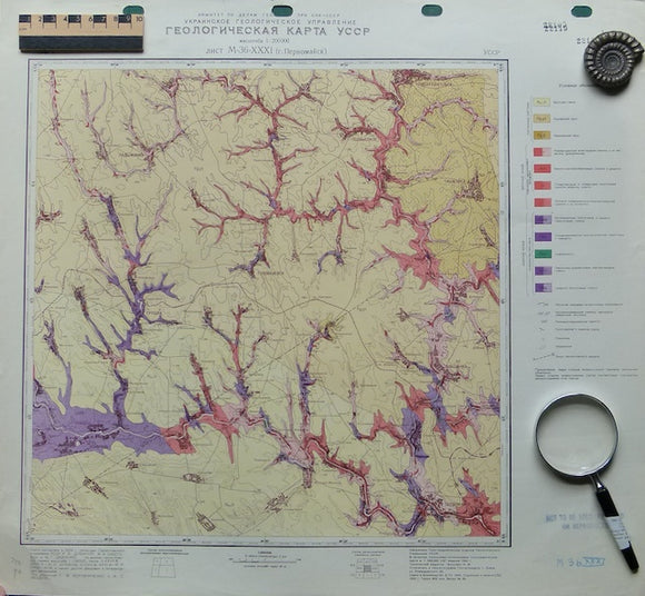
Malin, Sheet M-36-xxxi, 1940. Malin, Ukraine.
Malin, Sheet M-36-xxxi, 1940. From 1:200,000 scale series of the Geological Map of the Ukranian SSR. Flat colour printed map. Punched holes for hanging in top margin and library stamps...
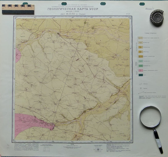
Pervomaisk, Sheet M-35-xii, 1940. Pervomaisk, Ukraine.
Pervomaisk, Sheet M-35-xii, 1940. 1:200,000 scale series of the Geological Map of the Ukranian SSR. Flat colour printed map. Punched holes for hanging in top margin and library stamps in...
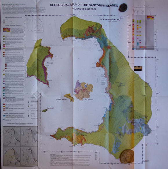
Geological Map of the Santorini Islands, 1999. Santorini.
Geological Map of the Santorini Islands, 1999, to accompany Geological Society Memoir 19. colour print, 100 x 98cm, folded to 28.5 x 21cm. As new.
Schmidt, F. (1882). 'Sketch Map of the Silurian (and Cambrian) System in the Eastern Baltic Provinces of Russia. Geological Society of London.
Regular price £1200 £12.00
Romania. 1961. Carte Geologique de la Vallee du Danube entre Drencova et T. Severin. 1:100,000 scale
Romania. 1961. Carte Geologique de la Vallee du Danube entre Drencova et T. Severin. 1:100,000 scale. Colour printed folded map, 36.5 x 52 cm. prepared for Association Geologique Carpato-Balkanique 5th...
Regular price £1000 £10.00
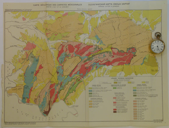
Romania. 1961. Carte Geologique des Carpates Meridionales (entre l’0lt at le Danube). 1:500,000
Romania. 1961. Carte Geologique des Carpates Meridionales (entre l’0lt at le Danube). 1:500,000 scale. Colour printed folded map, 38.5 x 51.5 cm. prepared for Association Geologique Carpato-Balkanique 5th congress. In...


![Judd, JW, (1876). ‘On the Ancient Volcano of the District of Schemnitz, Hungary [now Slovakia]’, extract from the Quarterly Journal of the Geological Society, v32,](http://geolmaps.com/cdn/shop/products/Schemnitz_Slovakia_{width}x.JPG?v=1547576090)
![Judd, JW, (1876). ‘On the Ancient Volcano of the District of Schemnitz, Hungary [now Slovakia]’, extract from the Quarterly Journal of the Geological Society, v32,](http://geolmaps.com/cdn/shop/products/Schemnitz_Slovakia_580x.JPG?v=1547576090)
![Poland. 1984. Mapa Geologiczna Polski I Krajow Osciennych; bez utworow kenozoicznych, mesosoicznych i permskich. [Geological Map of Poland and Adjoining Countries without Cenozoic, Mesozoic and Permian formations] Set of 3 maps](http://geolmaps.com/cdn/shop/products/P1080936_{width}x.JPG?v=1555761875)
![Poland. 1984. Mapa Geologiczna Polski I Krajow Osciennych; bez utworow kenozoicznych, mesosoicznych i permskich. [Geological Map of Poland and Adjoining Countries without Cenozoic, Mesozoic and Permian formations] Set of 3 maps](http://geolmaps.com/cdn/shop/products/P1080936_580x.JPG?v=1555761875)


![Bulgaria. 1965. Boncev Ek. & Dimitrov, C. Exkursionsfuhrer Sofia [A] – Belogradcik – Sofia.](http://geolmaps.com/cdn/shop/products/P1080872_{width}x.JPG?v=1555351746)
![Bulgaria. 1965. Boncev Ek. & Dimitrov, C. Exkursionsfuhrer Sofia [A] – Belogradcik – Sofia.](http://geolmaps.com/cdn/shop/products/P1080872_580x.JPG?v=1555351746)