Free UK postage
Dawson, J.W. (1847). ‘On the New Red Sandstone of Nova Scotia [Canada]’, extract from Quarterly Journal of the Geological Society, v.3, pt.1, pp.50-59 including one fold-out b/w geological map with section. Geological Society of London.
Dawson, J.W. (1847). ‘On the New Red Sandstone of Nova Scotia [Canada]’, extract from Quarterly Journal of the Geological Society, v.3, pt.1, pp.50-59 including one fold-out b/w geological map with...
Regular price £1400 £14.00
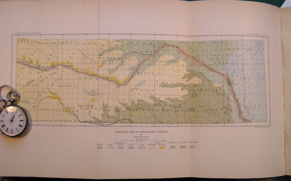
Geologic Map of Southwest Kansas in "A geological Reconnaisance in Southwestern Kansas" by Robert Hay in Bulletin No.57 of the USGS, 1890. USGS Kansas.
Geologic Map of Southwest Kansas in "A geological Reconnaisance in Southwestern Kansas" by Robert Hay in Bulletin No.57 of the USGS, 1890. Scale 1"=24miles. Colour print, 9"x15", folding out from...
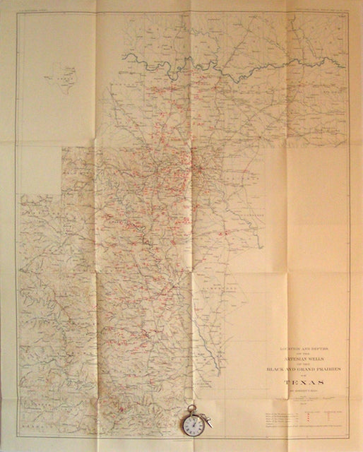
Location and Depth of the Artesian Wells of the Black and Grand Prairies of Texas, 1898. USGS Texas.
Location and Depth of the Artesian Wells of the Black and Grand Prairies of Texas, 1898 By Robert Hall, Plate 19 of USGS 21st annual report. Scale 1"=10miles. Folded colour...
Regular price £1200 £12.00
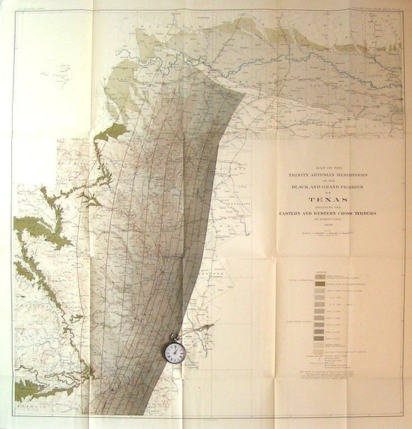
Map of the Trinity (formation) Artesian Reservoirs of the Black and Grand Prairies of Texas, 1900. USGS Texas.
Map of the Trinity (formation) Artesian Reservoirs of the Black and Grand Prairies of Texas, 1900. By Robert Hall, Plate 71 of USGS 21st annual report. Scale 1"=10miles. Folded colour...
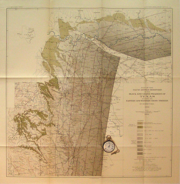
Map of the Paluxy (formation) Artesian Reservoirs of the Black and Grand Prairies of Texas, 1900. USGS Texas.
Map of the Paluxy (formation) Artesian Reservoirs of the Black and Grand Prairies of Texas, 1900. By Robert Hall, Plate 70 of USGS 21st annual report. Scale 1"=10miles. Folded colour...
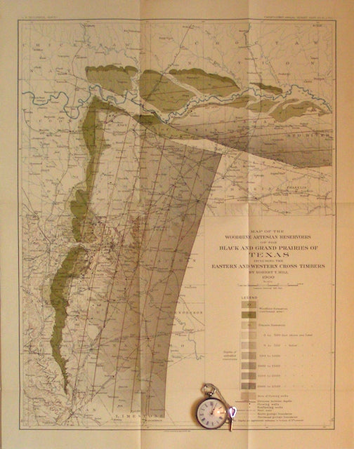
Map of the Woodbine (formation) Artesian Reservoirs of the Black and Grand Prairies of Texas, 1900. USGS Texas.
Map of the Woodbine (formation) Artesian Reservoirs of the Black and Grand Prairies of Texas, 1900. By Robert Hall, Plate 71 of USGS 21st annual report. Scale 1"=10miles. Folded colour...
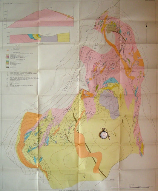
Map and Sections of the Quad Creek Area, Montana. Geol.Soc. Am Montana.
Map and Sections of the Quad Creek Area, Montana, 1957. Scale 1:6000. Plate 5 from Bull. Geol.Soc.Am. v.68. Folded, colour print, 41"x34". Covers a small area of complex Precambrian banded...
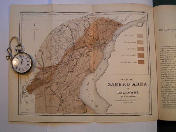
Map of Gabbros Area in Delaware in "The Gabbros and Associated Rocks in Delaware" by FD Chester in Bulletin No. 59 of the USGS, 1890. Scale 1"=3miles. Colour print, 9"x11.5". USGS Delaware.
Map of Gabbros Area in Delaware in "The Gabbros and Associated Rocks in Delaware" by FD Chester in Bulletin No. 59 of the USGS, 1890. Scale 1"=3miles. Colour print, 9"x11.5",...
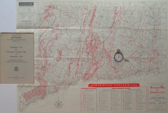
Preliminary Geological Map of Connecticut, 1956. Connecticut.
Preliminary Geological Map of Connecticut, 1956. In Connecticut Geological and Natural History Survey, Bulletin 8. Scale 1:253,440. Folded colour print 20.5"x27.5". Outline boundaries and formation abbreviations in red on grey...
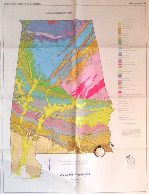
Aquifers in Alabama; Aquifer Recharge Areas, 1998. Alabama.
Aquifers in Alabama; Aquifer Recharge Areas, 1998,revision.by Geologic Survey of Alabama, special paper 231. Scale 1"=13miles. Folded colour print. Clean bright excellent graphic. On reverse, a 1:2,000,000 map relating ground...
Greenland. Preliminary Geological Map of the Agto-Nordre Stromfjord Region (1970). Geological Survey of Greenland. Folded b/w map, 1:200,000. Geological Survey of Greenland.
Greenland. Preliminary Geological Map of the Agto-Nordre Stromfjord Region (1970). Geological Survey of Greenland. Folded b/w map, 1:200,000, 61 x 66cm folding to 23 x 16cm. Clean, negligible wear. In...
Regular price £1000 £10.00
Greenland. Preliminary Geological Map of the Fiskenaesset Region (1972). Geological Survey of Greenland. Folded b/w map, 1:100,000. Geological Survey of Greenland.
Greenland. Preliminary Geological Map of the Fiskenaesset Region (1972). Geological Survey of Greenland. Folded b/w map, 1:100,000, 60 x 124cm folding to 31 x 14cm. Clean, age-toned negligible wear. Compiled...
[Geological] Map of the Coal Fields of the United States, New Brunswick and Nova-Scotia, 1869, Plate 8, from Mines and Miners; or, Underground Life by L. Simonin
[Geological] Map of the Coal Fields of the United States, New Brunswick and Nova-Scotia, 1869, Plate 8, from Mines and Miners; or, Underground Life by L. Simonin. London: Chapman and...
Regular price £700 £7.00
![Dawson, J.W. (1847). ‘On the New Red Sandstone of Nova Scotia [Canada]’, extract from Quarterly Journal of the Geological Society, v.3, pt.1, pp.50-59 including one fold-out b/w geological map with section](http://geolmaps.com/cdn/shop/files/QJGS1840s_5_DawsonNScotia_{width}x.jpg?v=1742250012)
![Dawson, J.W. (1847). ‘On the New Red Sandstone of Nova Scotia [Canada]’, extract from Quarterly Journal of the Geological Society, v.3, pt.1, pp.50-59 including one fold-out b/w geological map with section](http://geolmaps.com/cdn/shop/files/QJGS1840s_5_DawsonNScotia_580x.jpg?v=1742250012)


![[Geological] Map of the Coal Fields of the United States, New Brunswick and Nova-Scotia, 1869, Plate 8, from Mines and Miners; or, Underground Life by L. Simonin](http://geolmaps.com/cdn/shop/products/P1080649_{width}x.JPG?v=1551270902)
![[Geological] Map of the Coal Fields of the United States, New Brunswick and Nova-Scotia, 1869, Plate 8, from Mines and Miners; or, Underground Life by L. Simonin](http://geolmaps.com/cdn/shop/products/P1080649_580x.JPG?v=1551270902)