
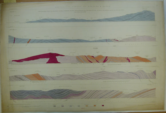


Horizontal Section No. 37 (1854). From Harlech, over Rhinog and Rhobell-fawr, Moel-ddu (N. end of Aran range), Pen-y-boncyn, the Berwyns, to Oswestry. Geological Survey of GB. 2nd
Horizontal Section No. 37 (1854). From Harlech, Cardigan Bay, Merionthshire, over Rhinog and Rhobell-fawr, Moel-ddu (north end of Aran range), Pen-y-boncyn, Post-gwyn (the Berwyns), to, Oswestry. Geological Survey of GB. 2nd edition. Located on Old Series one-inch maps 75se and 74sw. Hand coloured engraving 69.5 x102cm, 1:10,560 scale (6”= 1mile). Flat, slightly age-toned. Clean, bright (coloured 1934). In very good condition.
About England & Wales Sections
These hand-coloured engraved ‘horizontal’ sections at six inch to one mile scale were published in the mid 19th century by the Geological Survey of England and Wales. The detailed profiles generally follow the geological dip on the one inch Old Series maps numbered in the upper right hand margin and the profile locations are shown on these maps which themselves did not include a section.