


Horizontal Section No. 45 (1858). No.1. Coalbrook Dale, Wrottesley Park, the South Staffordshire Coalfield by to Lichfield Road. 2. From Preston Brockhurst to Hawkstone Park. Geological Survey of GB. 2nd
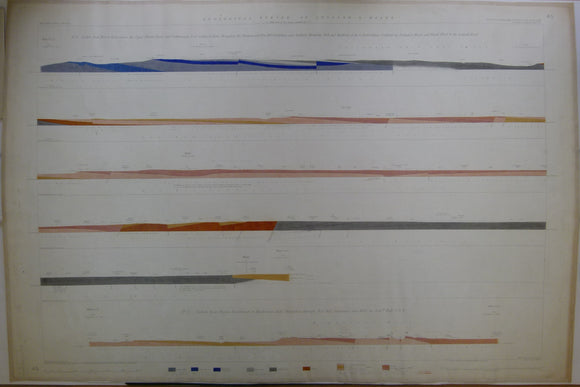
Horizontal Section No. 45 (1858). No.1 From west to east, across Upper Silurian Rocks and Coalmeasures south of Coalbrook Dale, Shropshire, near Beckbury, Wrottesley Park and Bushbury and the South Staffordshire Coalfield by Essington Wood and Pelsall Wood to the Lichfield Road. 2. From Preston Brockhurst to Hawkstone Park, Shropshire. Geological Survey of GB. 2nd edition. Located on Old Series one-inch maps 61ne, 62nw & ne, and 73sw. Hand coloured engraving 69.5 x 103cm, 1:10,560 scale (6”= 1mile). Flat, linen-taped edge, slightly age-toned, library stamp on back. Coloured 1920. In good condition.
About England & Wales Sections
These hand-coloured engraved ‘horizontal’ sections at six inch to one mile scale were published in the mid 19th century by the Geological Survey of England and Wales. The detailed profiles generally follow the geological dip on the one inch Old Series maps numbered in the upper right hand margin and the profile locations are shown on these maps which themselves did not include a section.