
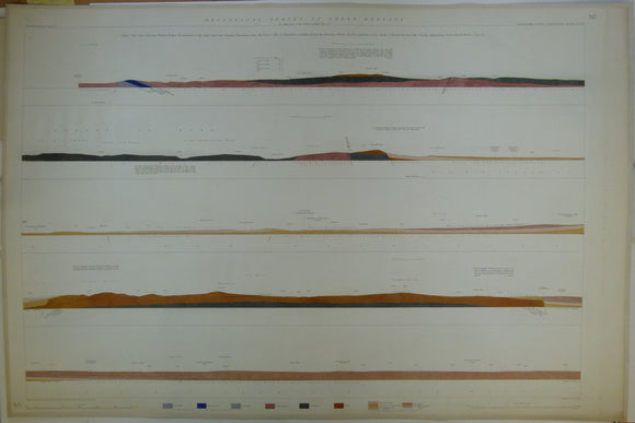


Horizontal Section No. 50 (1858). Cleobury Mortimer, Worcestershire, to Ashby Canal, nr Nuneaton, Warwickshire, across Forest of Wyre and Warwickshire Coalfield, through Warshill, the Client Hills, Meriden, Corley, etc. Geological Survey of GB. 2nd
Horizontal Section No. 50 (1858). From Neen Soller near Cleobury Mortimer, Worcestershire, to the Ashby Canal, near Nuneaton, Warwickshire, across the Forest of Wyre and the Warwickshire Coalfield, through the Permian New Red Sandstone and Lias of Warshill, the Client Hills, Frankley Beeches, King’s Norton,Knowle, Meriden, Corley, etc. Geological Survey of GB. 2nd edition. Located on Old Series one-inch maps 55ne, 54nw & ne, 62se and 63sw. Hand-coloured engraving 68.5 x 102cm, 1:10,560 scale (6”= 1mile). Flat, linen-taped edge, slightly age-toned, slightly soiled right margin. Library stamp on back. Bright colours (coloured 1920). In good to very good condition.
About England & Wales Sections
These hand-coloured engraved ‘horizontal’ sections at six inch to one mile scale were published in the mid 19th century by the Geological Survey of England and Wales. The detailed profiles generally follow the geological dip on the one inch Old Series maps numbered in the upper right hand margin and the profile locations are shown on these maps which themselves did not include a section.