
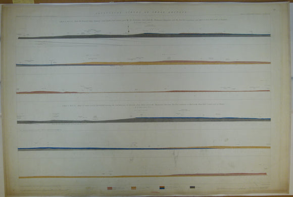


Horizontal Section No. 61 (1861). 1.From the Erewash Valley Railway, nr Codnor Park, across the Derbyshire Coalfield, to S of Birmingham. 2.From E of Chesterfield, across the Coal Measures, to E of Ollerton. Geological Survey of GB. 1st
Horizontal Section No. 61 (1861). 1. W to E from the Erewash Valley Railway, near Codnor Park, across the Derbyshire Coalfield, to Toot Hill, S of Birmingham. 2. From W to E ,from 2½ miles E of Chesterfield, crossing the Coal Measures, to the windmill 3 ½ miles E of Ollerton. Geological Survey of GB. 1st edition. Located on Old Series one-inch maps 71nw and ne, 82sw and se. Hand-coloured engraving, 69 x 103cm, 1:10,560 scale (6”= 1mile). Flat, linen-taped edges, slightly age-toned, library stamp on back. scuff marks across centre, otherwise clean, (coloured 1923). In good condition.
About England & Wales Sections
These hand-coloured engraved ‘horizontal’ sections at six inch to one mile scale were published in the mid 19th century by the Geological Survey of England and Wales. The detailed profiles generally follow the geological dip on the one inch Old Series maps numbered in the upper right hand margin and the profile locations are shown on these maps which themselves did not include a section.