
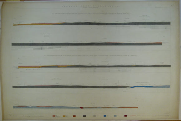


Horizontal Section No. 52 (1858). From Newton Solney, across Ashby-de-la-Zouch coalfield, to Moira and Measham Hall. From Linton, Ashby Wolds, Coleorton Common, and Charnwood Forest. Geological Survey of GB. 1st
Horizontal Section No. 52 (1858). From N to S, from the Trent at Newton Solney to Swepstone, crossing the Ashby-de-la-Zouch coalfield at Newall, Greslay, to Moira and Measham Hall. From W to E, by Linton, the Coal Measures of Ashby Wolds, Coleorton Common, and the Cambrian Rocks of Charnwood Forest. Geological Survey of GB. 1st edition. Located on Old Series one-inch maps 62ne, 63nw & ne, and 71sw. Hand coloured engraving 69 x102.5cm, 1:10,560 scale (6”= 1mile). Flat, linen-taped edges, slightly age-toned, library stamp on back. Clean, (coloured 1918). In very good condition.
About England & Wales Sections
These hand-coloured engraved ‘horizontal’ sections at six inch to one mile scale were published in the mid 19th century by the Geological Survey of England and Wales. The detailed profiles generally follow the geological dip on the one inch Old Series maps numbered in the upper right hand margin and the profile locations are shown on these maps which themselves did not include a section.