
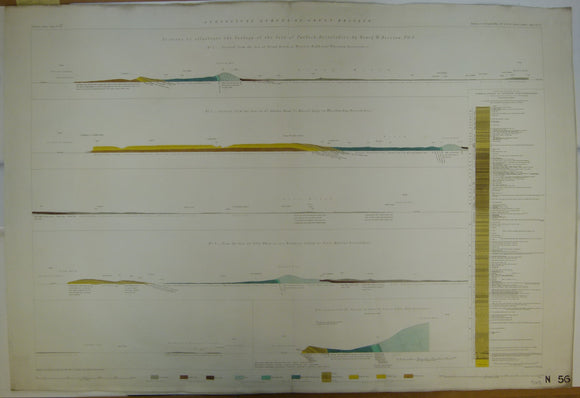


Horizontal Section No. 56 (1859). Sections to Illustrate the Geology of the Isle of Purbeck, Dorsetshire. Geological Survey of GB. 1st edition.
Horizontal Section No. 56 (1859). Sections to Illustrate the Geology of the Isle of Purbeck, Dorsetshire. 1. From the sea at Broad Bench to Worgert Heat, near Warham. 2. From the sea, at St.Alban’s Head, to Russel Quay, in Wareham Bay. 3.From the sea at Tilly Whim, across Branksea Island, to Poole Harbour. 4. From the sea East to Lulworth Cove, to Bindon Hill (scale 1:2,376). 5. Vertical Section at Lulworth Cove. Geological Survey of GB. 1st edition. Located on Old Series one-inch maps 16 and 17. Hand-coloured engraving 69 x 101cm, 1:10,560 scale (6”= 1mile). Flat, old centre fold, blind stamp in lower left corner and stencilled number in lower right corner. Clean, bright and in very good condition.
About England & Wales Sections
These hand-coloured engraved ‘horizontal’ sections at six inch to one mile scale were published in the mid 19th century by the Geological Survey of England and Wales. The detailed profiles generally follow the geological dip on the one inch Old Series maps numbered in the upper right hand margin and the profile locations are shown on these maps which themselves did not include a section.