
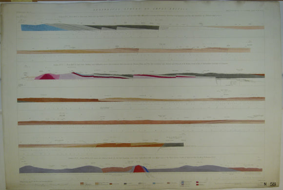


Horizontal Section No. 58 (1860). 1. From Pentre-Cefn, by Dryll, Twyford Cross and Boreaton Park. 2. From Cluddley, by Shiffnal to S of Cannock. 3. From Furrow Hill over Nash Scar to Eywood Park. Geological Survey of GB. 1st
Horizontal Section No. 58 (1860). 1. From W to E, from Pentre-Cefn, by Dryll, S of Oswestry, Twyford Cross and Boreaton Park, Shropshire. 2. From W to E, from Cluddley, near Wellington, across the Coalbrook Dale Coalfield,near Shiffnal and Brewood to the W Border of the S. Staffordshire Coalfield, S of Cannock. 3. From NW to SE across the Silurian Rocks and Old Red Sandstone, from Offa’s Dyke, Furrow Hill over Nash Scar to the River Arrow, S of Eywood Park. Geological Survey of GB. 1st edition. Located on Old Series one-inch maps 56ne and se, 61ne, 62nw, 73sw, and 74se. Hand-coloured engraving 69 x 101.5cm, 1:10,560 scale (6”= 1mile). Flat, old centre fold, slightly soiled, slightly age-toned, blind stamp in lower left corner and stencilled number in lower right corner. In good to very good condition.