
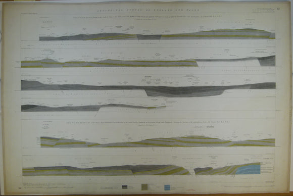


Horizontal Section No. 62 (1870). 1. From Harwood Church, across the Burnley Coalfield to Colne. 2. From Bull Hill, nr Todmorden, by Newchurch-in-Rossendale, to Black Hambledon. Geological Survey of GB. 1st.
Horizontal Section No. 62 (1870). 1. From Harwood Church, on the S., to Colne, on the N., across the Burnley Coalfield, and adjoining tracts of Affeside, Holcombe Moor and Haslingden. 2. From Bull Hill, on the SW to Black Hambledon, near Todmorden, on the NE, by Newchurch-in-Rossendale, by Bacup, and Portsmouth. Geological Survey of GB. 1st edition. Located on Old Series one-inch maps 89ne and se, 88nw, 92sw. Hand coloured engraving 69 x103.5cm, 1:10,560 scale (6”= 1mile). Flat, linen-taped edges, slightly age-toned, library stamp on back. Clean, (coloured 1923). In very good condition.
About England & Wales Sections
These hand-coloured engraved ‘horizontal’ sections at six inch to one mile scale were published in the mid 19th century by the Geological Survey of England and Wales. The detailed profiles generally follow the geological dip on the one inch Old Series maps numbered in the upper right hand margin and the profile locations are shown on these maps which themselves did not include a section.