
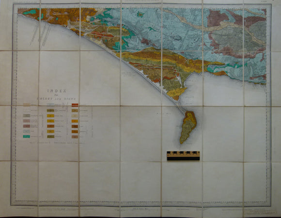
Sheet 17, Old Series 1". Covering Weymouth and Portland Bill. 1886.
Sheet 17, Old Series 1". Covering Weymouth and Portland Bill. 1886. Hand-coloured engraving, 67.5 x 87.5cm, dissected and mounted on linen folding between marbled soft card covers. Covers coast between Charmouth and Lulworth Cove. Base map topographygraphy 1811 with railways added 1886. The geology was originally published in 1855. The actual map was issued in 1903. The map is 65% sea and has an enlarged legend in the sea area. Colours clean and bright, light pencil annotation along shore, in very good condition
About the England & Wales One Inch Old Series
The Geological Survey of England and Wales used the Old Series of the Ordnance Survey topographic map at a scale of one inch to the mile as its basemap, initially. These engraved basemaps were published and revised between 1805 and 1885; the sheet sizes varied and the layout and numbering system were eccentric. The Old Series geological maps were hand-coloured and without geological sections, which were published separately. The GS of E&W published the Old Series from 1850 to 1900, when it switched to the colour printing and the New Series one inch maps. However, old stock of the Old Series continued to be issued, hand-coloured, until the 1930s.
See also: Index Map for England & Wales One Inch Old Series.