Free UK postage
Sheet 95nw, Old Series 1". 1881. First edition. Yorkshire: Scalby, Robin Hood’s Bay. Hand-coloured engraving. Geological Survey of England & Wales.
Sheet 95sw, Old Series 1". 1881. First edition. Yorkshire: Scarborough, Filey, Snainton. Hand-coloured. Geological Survey of England & Wales.
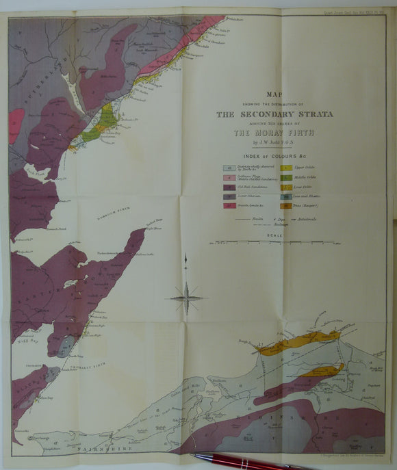
Judd, John W., (1873), ‘Map Showing the Secondary Strata around the Shores of the Moray Firth. Fold-out colour printed geological map. QJGS.
Judd, J.W. (1873). [Geological] Map Showing ... the Secondary Strata Around the Moray Firth [Scotland], fold-out colour printed map,. Geological Society of London.
Bailey, E.B. (1916).’The Islay Anticline (Inner Hebrides)’ extract from the Quarterly Journal of the Geological Society, v.72,. Geological Society of London.


![Judd, J.W. (1873). [Geological] Map Showing ... the Secondary Strata Around the Moray Firth [Scotland], fold-out colour printed map,](http://geolmaps.com/cdn/shop/products/Judd2ndryScotland_1_{width}x.jpg?v=1619627314)
![Judd, J.W. (1873). [Geological] Map Showing ... the Secondary Strata Around the Moray Firth [Scotland], fold-out colour printed map,](http://geolmaps.com/cdn/shop/products/Judd2ndryScotland_1_580x.jpg?v=1619627314)

