Free UK postage
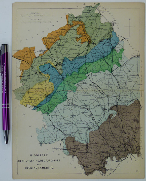
Bedfordshire, Buckinghamshire, Hertfordshire, and Middlesex (1864) counties geological map from Reynolds’s Geological Atlas of Great Britain, 1st edition. Reynolds.
Bedfordshire, Buckinghamshire, Hertfordshire, and Middlesex (1864) counties geological map from Reynolds’s Geological Atlas of Great Britain, 1st edition. Approx. 1:480,000 scale. Hand-coloured map 16.5 x 25cm with centre fold. In...
Regular price £1500 £15.00
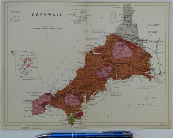
Cornwall (1889) county geological map from Reynolds’s Geological Atlas of Great Britain, 2nd edition. Reynolds.
Cornwall (1889) county geological map from Reynolds’s Geological Atlas of Great Britain, 2nd edition. Approx. 1:480,000 scale. Hand-coloured map 16.5 x 25cm with centre fold. Age-toned, tears beginning at ends...
Regular price £1200 £12.00
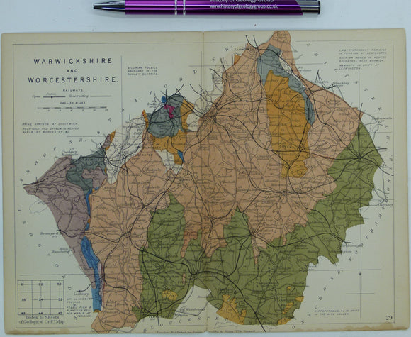
Warwickshire and Worcestershire (1889) counties geological map from Reynolds’s Geological Atlas of Great Britain, 2nd. Reynolds.
Warwickshire and Worcestershire (1889) counties geological map from Reynolds’s Geological Atlas of Great Britain, 2nd edition. Approx. 1:640,000 scale. Hand-coloured map, 16.5 x 25cm with centre fold. Age-toned, tears beginning...
Surrey and Sussex (1889) counties geological map from Reynolds’s Geological Atlas of Great Britain, 2nd edition. Reynolds.
Surrey and Sussex (1889) counties geological map from Reynolds’s Geological Atlas of Great Britain, 2nd edition. Approx. 1:480,000 scale. Hand-coloured map 16.5 x 25cm with centre fold. Age-toned, tears beginning...
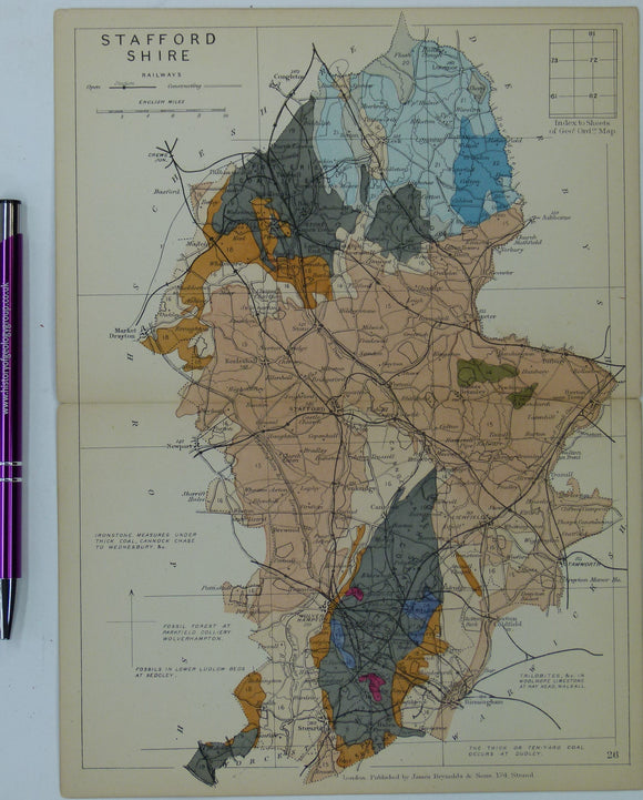
Staffordshire (1889) county geological map from Reynolds’s Geological Atlas of Great Britain, 2nd. Reynolds.
Staffordshire (1889) county geological map from Reynolds’s Geological Atlas of Great Britain, 2nd edition. Approx. 1:480,000 scale. Hand-coloured map 16.5 x 25cm with centre fold. Age-toned, tears beginning at ends...
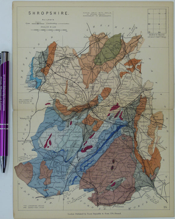
Shropshire (1889) county geological map from Reynolds’s Geological Atlas of Great Britain, 2nd edition. rey.
Shropshire (1889) county geological map from Reynolds’s Geological Atlas of Great Britain, 2nd edition. Approx. 1:480,000 scale. Hand-coloured map 16.5 x 25cm with centre fold. Age-toned, tears beginning at ends...
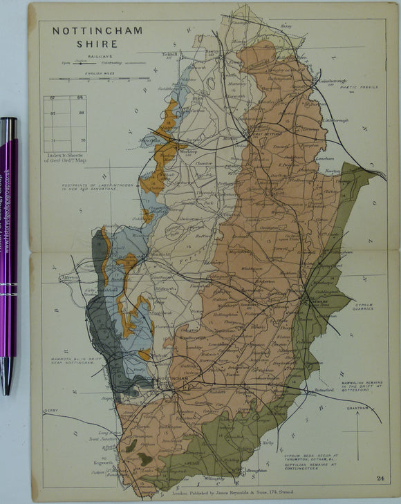
Nottinghamshire (1889) county geological map from Reynolds’s Geological Atlas of Great Britain, 2nd edition. Reynolds.
Nottinghamshire (1889) county geological map from Reynolds’s Geological Atlas of Great Britain, 2nd edition. Approx. 1:480,000 scale. Hand-coloured map 16.5 x 25cm with centre fold. Age-toned, tears beginning at ends...
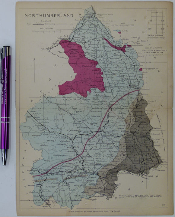
Northumberland (1889) county geological map from Reynolds’s Geological Atlas of Great Britain, 2nd edition. Reynolds.
Northumberland (1889) county geological map from Reynolds’s Geological Atlas of Great Britain, 2nd edition. Approx. 1:480,000 scale. Hand-coloured map 16.5 x 25cm with centre fold. Age-toned, tears beginning at ends...
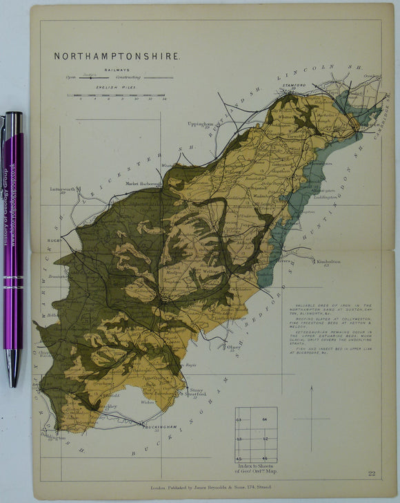
Northamptonshire (1889) county geological map from Reynolds’s Geological Atlas of Great Britain, 2nd edition. Reynolds.
Northamptonshire (1889) county geological map from Reynolds’s Geological Atlas of Great Britain, 2nd edition. Approx. 1:480,000 scale. Hand-coloured map 16.5 x 25cm with centre fold. Age-toned, tears beginning at ends...
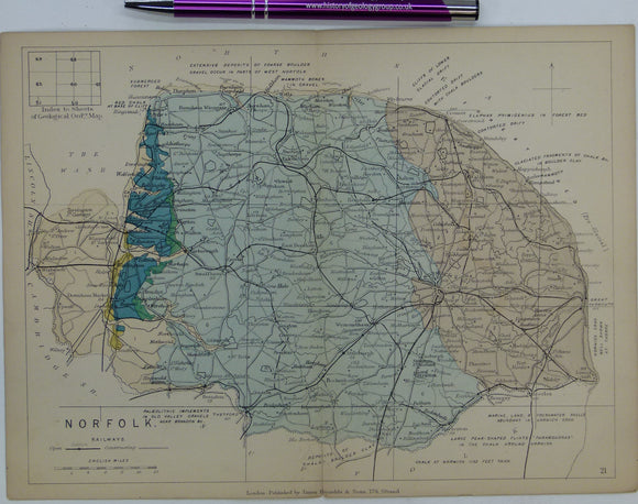
Norfolk (1889) county geological map from Reynolds’s Geological Atlas of Great Britain, 2nd edition. Reynolds.
Norfolk (1889) county geological map from Reynolds’s Geological Atlas of Great Britain, 2nd edition. Approx. 1:480,000 scale. Hand-coloured map 16.5 x 25cm with centre fold. Age-toned, tears beginning at ends...
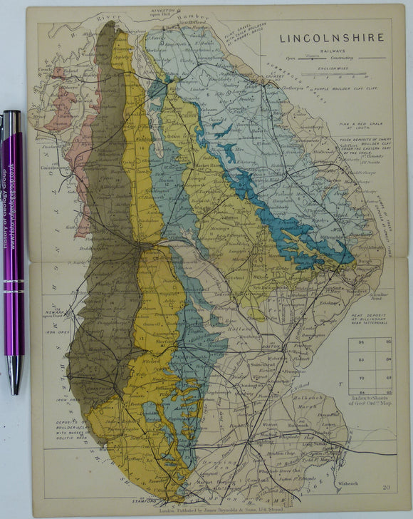
Lincolnshire (1889) county geological map from Reynolds’s Geological Atlas of Great Britain, 2nd edition. Reynolds.
Lincolnshire (1889) county geological map from Reynolds’s Geological Atlas of Great Britain, 2nd edition. Approx. 1:480,000 scale. Hand-coloured map 16.5 x 25cm with centre fold. Age-toned, tears beginning at ends...
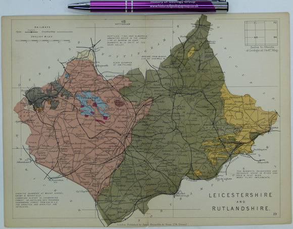
Leicestershire and Rutlandshire (1889) counties geological map from Reynolds’s Geological Atlas of Great Britain, 2nd. Reynolds.
Leicestershire and Rutlandshire (1889) counties geological map from Reynolds’s Geological Atlas of Great Britain, 2nd edition. Approx. 1:350,000 scale. Hand-coloured map 16.5 x 25cm with centre fold. Age-toned, tears beginning...
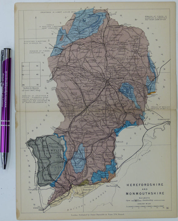
Herefordshire and Monmouthshire (now part of Wales) (1889) counties geological map from Reynolds’s Geological Atlas of Great Britain, 2nd. Reynolds.
Herefordshire and Monmouthshire (now part of Wales) (1889) counties geological map from Reynolds’s Geological Atlas of Great Britain, 2nd edition. Approx. 1:480,000 scale. Hand-coloured map 16.5 x 25cm with centre...
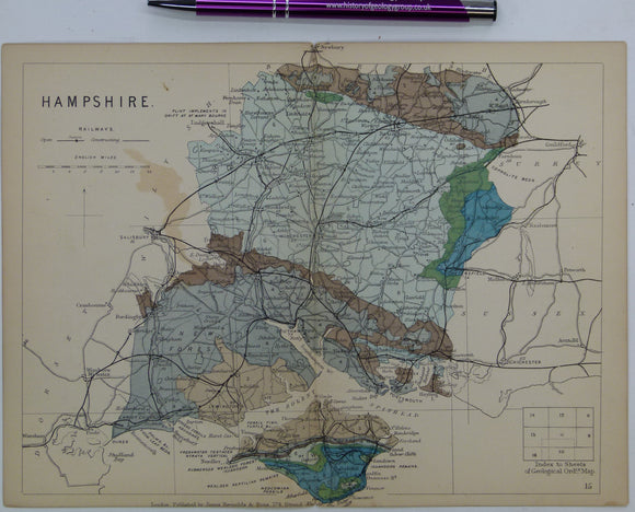
Hampshire including Isle of Wight (1889) counties geological map from Reynolds’s Geological Atlas of Great Britain, 2nd. Reynolds.
Hampshire including Isle of Wight (1889) counties geological map from Reynolds’s Geological Atlas of Great Britain, 2nd edition. Approx. 1:480,000 scale. Hand-coloured map 16.5 x 25cm with centre fold. Age-toned,...
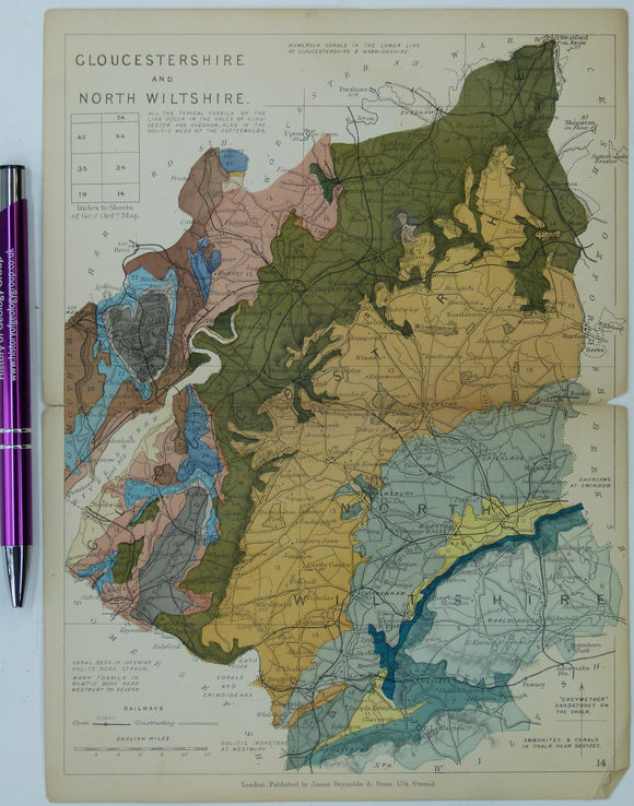
Gloucestershire and North Wiltshire (1889) counties geological map from Reynolds’s Geological Atlas of Great Britain, 2nd. Reynolds.
Gloucestershire and North Wiltshire (1889) counties geological map from Reynolds’s Geological Atlas of Great Britain, 2nd edition. Approx. 1:480,000 scale. Hand-coloured map 16.5 x 25cm with centre fold. Age-toned, tears...
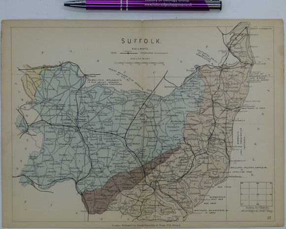
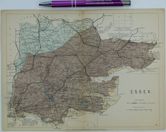
Essex (1889) county geological map from Reynolds’s Geological Atlas of Great Britain, 2nd edition. Reynolds.
Essex (1889) county geological map from Reynolds’s Geological Atlas of Great Britain, 2nd edition. Approx. 1:480,000 scale. Hand-coloured map 16.5 x 25cm with centre fold. Age-toned, tears beginning at ends...
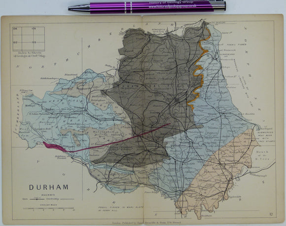
Durham (1889) county geological map from Reynolds’s Geological Atlas of Great Britain, 2nd edition. Reynolds.
Durham (1889) county geological map from Reynolds’s Geological Atlas of Great Britain, 2nd edition. Approx. 1:350,000 scale. Hand-coloured map 16.5 x 25cm with centre fold. Age-toned, tears beginning at ends...
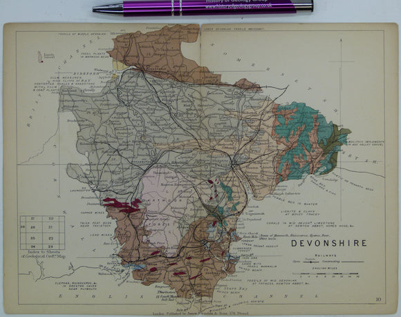
Devon (1889) county geological map from Reynolds’s Geological Atlas of Great Britain, 2nd edition. Reynolds.
Devon (1889) county geological map from Reynolds’s Geological Atlas of Great Britain, 2nd edition. Approx. 1:480,000 scale. Hand-coloured map 16.5 x 25cm with centre fold. Age-toned, tears beginning at ends...
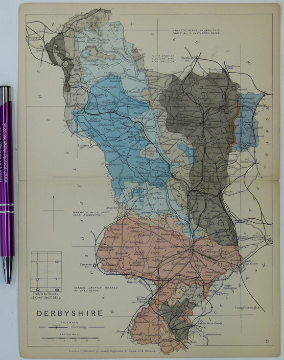
Derbyshire (1889) county geological map from Reynolds’s Geological Atlas of Great Britain, 2nd edition. Reynolds.
Derbyshire (1889) county geological map from Reynolds’s Geological Atlas of Great Britain, 2nd edition. Approx. 1:480,000 scale. Hand-coloured map 16.5 x 25cm with centre fold. Age-toned, tears beginning at ends...
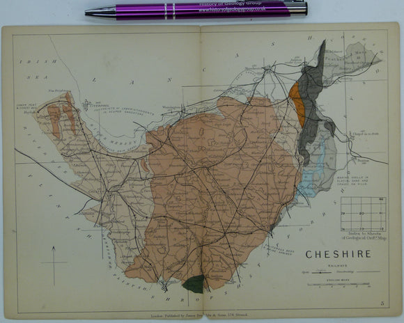
Cheshire (1889) county geological map from Reynolds’s Geological Atlas of Great Britain, 2nd edition. Reynolds.
Cheshire (1889) county geological map from Reynolds’s Geological Atlas of Great Britain, 2nd edition. Approx. 1:480,000 scale. Hand-coloured map 16.5 x 25cm with centre fold. Age-toned, tears beginning at ends...