Free UK postage
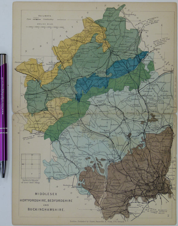
Bedfordshire, Buckinghamshire, Hertfordshire, and Middlesex (1889) counties geological map from Reynolds’s Geological Atlas of Great Britain, 2nd. Reynolds.
Bedfordshire, Buckinghamshire, Hertfordshire, and Middlesex (1889) counties geological map from Reynolds’s Geological Atlas of Great Britain, 2nd edition. Approx. 1:480,000 scale. Hand-coloured map 16.5 x 25cm with centre fold. Age-toned,...
Regular price £1200 £12.00
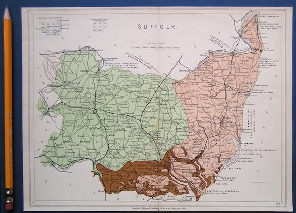
Suffolk (1913) county geological map from Stanford’s Geological Atlas of Great Britain and Ireland, 3rd edition. Stanford's and Reynolds' Atlases.
Suffolk (1913) county geological map from Stanford’s Geological Atlas of Great Britain and Ireland, 3rd edition. Approx. 1:480,000 scale. Colour printed map 16.5 x 25cm with centre fold, in good...
Regular price £1000 £10.00
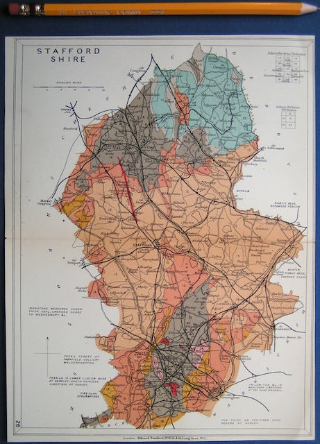
Staffordshire (1913) county geological map from Stanford’s Geological Atlas of Great Britain and Ireland, 3rd edition. Stanford's and Reynolds' Atlases.
Staffordshire (1913) county geological map from Stanford’s Geological Atlas of Great Britain and Ireland, 3rd edition. Approx. 1:400,000 scale. Colour printed map 16.5 x 25cm with centre fold, in good...
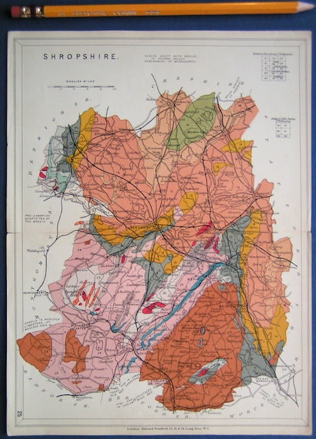
Shropshire (1913) county geological map from Stanford’s Geological Atlas of Great Britain and Ireland, 3rd edition. Stanford's and Reynolds' Atlases.
Shropshire (1913) county geological map from Stanford’s Geological Atlas of Great Britain and Ireland, 3rd edition. Approx. 1:480,000 scale. Colour printed map 16.5 x 25cm with centre fold, in good...
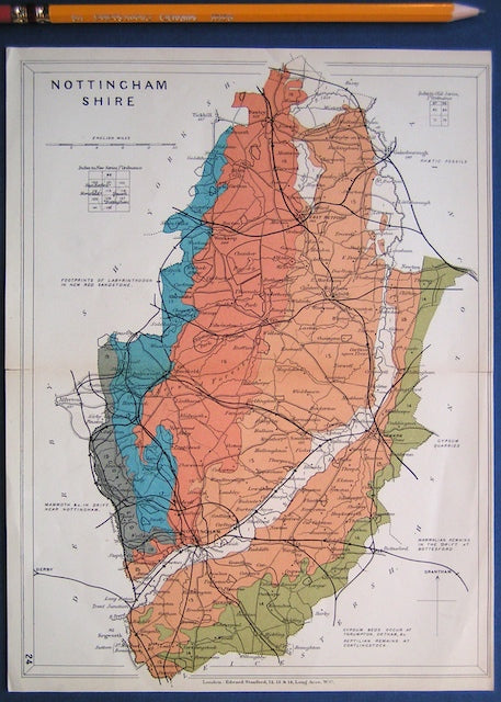
Nottinghamshire (1913) county geological map from Stanford’s Geological Atlas of Great Britain and Ireland, 3rd edition. Stanford's and Reynolds' Atlases.
Nottinghamshire (1913) county geological map from Stanford’s Geological Atlas of Great Britain and Ireland, 3rd edition. Approx. 1:350,000 scale. Colour printed map 16.5 x 25cm with centre fold, in good...
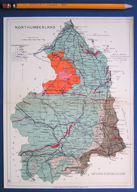
Northumberland (1913) county geological map from Stanford’s Geological Atlas of Great Britain and Ireland, 3rd edition. Stanford's and Reynolds' Atlases.
Northumberland (1913) county geological map from Stanford’s Geological Atlas of Great Britain and Ireland, 3rd edition. Approx. 1:350,000 scale. Colour printed map 16.5 x 25cm with centre fold, in good...
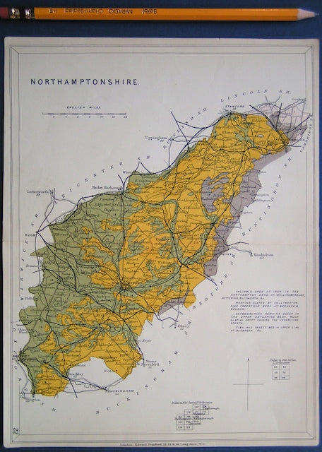
Northamptonshire (1913) county geological map from Stanford’s Geological Atlas of Great Britain and Ireland, 3rd edition. Stanford's and Reynolds' Atlases.
Northamptonshire (1913) county geological map from Stanford’s Geological Atlas of Great Britain and Ireland, 3rd edition. Approx. 1:480,000 scale. Colour printed map 16.5 x 25cm with centre fold, in good...
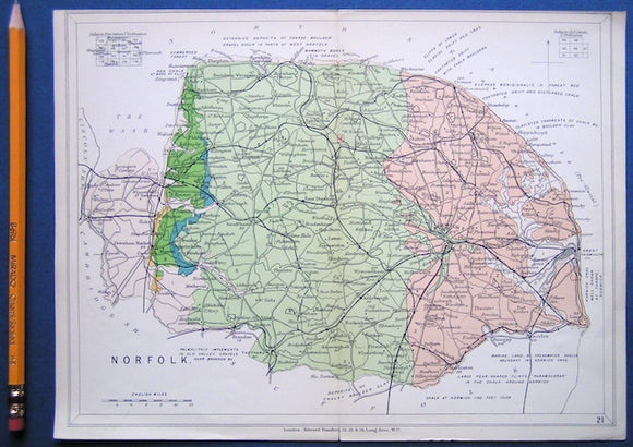
NorfolkNorfolk (1913) county geological map from Stanford’s Geological Atlas of Great Britain and Ireland, 3rd edition. Stanford's and Reynolds' Atlases.
Norfolk (1913) county geological map from Stanford’s Geological Atlas of Great Britain and Ireland, 3rd edition. Approx. 1:480,000 scale. Colour printed map 16.5 x 25cm with centre fold, in good...
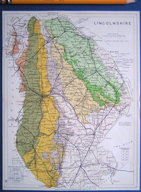
Lincolnshire (1913) county geological map from Stanford’s Geological Atlas of Great Britain and Ireland, 3rd edition. Stanford's and Reynolds' Atlases.
Lincolnshire (1913) county geological map from Stanford’s Geological Atlas of Great Britain and Ireland, 3rd edition. Approx. 1:480,000 scale. Colour printed map 16.5 x 25cm with centre fold, in good...
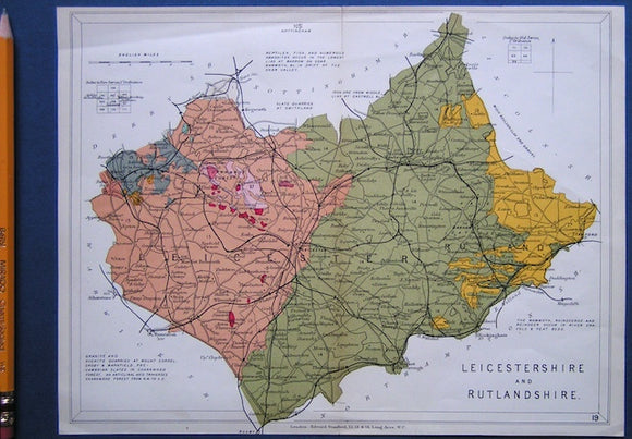
Leicestershire and Rutlandshire (1913) counties geological map from Stanford’s Geological Atlas of Great Britain and Ireland, 3rd edition. Stanford's and Reynolds' Atlases.
Leicestershire and Rutlandshire (1913) counties geological map from Stanford’s Geological Atlas of Great Britain and Ireland, 3rd edition. Approx. 1:350,000 scale. Colour printed map 16.5 x 25cm with centre fold,...
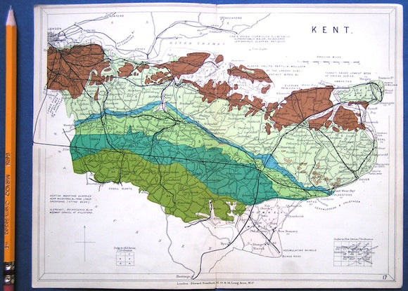
Kent (1913) county geological map from Stanford’s Geological Atlas of Great Britain and Ireland, 3rd edition. Stanford's and Reynolds' Atlases.
Kent (1913) county geological map from Stanford’s Geological Atlas of Great Britain and Ireland, 3rd edition. Approx. 1:480,000 scale. Colour printed map 16.5 x 25cm with centre fold, in good...
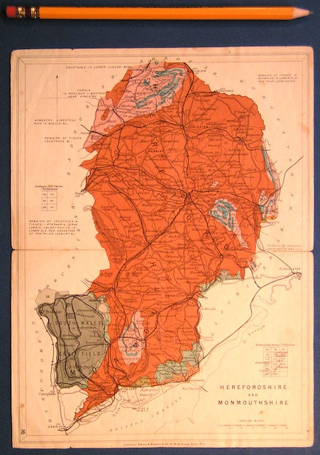
Herefordshire and Monmouthshire (now part of Wales) (1913) counties geological map from Stanford’s Geological Atlas of Great Britain and Ireland,. Stanford's and Reynolds' Atlases.
Herefordshire and Monmouthshire (now part of Wales) (1913) counties geological map from Stanford’s Geological Atlas of Great Britain and Ireland, 3rd edition. Approx. 1:480,000 scale. Colour printed map 16.5 x...
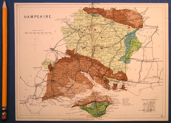
Hampshire including Isle of Wight (1913) county geological map from Stanford’s Geological Atlas of Great Britain and Ireland, 3rd ed. Stanford's and Reynolds' Atlases.
Hampshire including Isle of Wight (1913) county geological map from Stanford’s Geological Atlas of Great Britain and Ireland, 3rd edition. Approx. 1:480,000 scale. Colour printed map 16.5 x 25cm with...
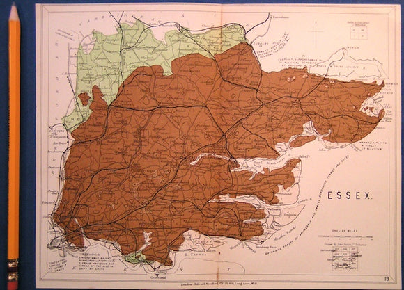
Essex (1913) county geological map from Stanford’s Geological Atlas of Great Britain and Ireland, 3rd edition. Stanford's and Reynolds' Atlases.
Essex (1913) county geological map from Stanford’s Geological Atlas of Great Britain and Ireland, 3rd edition. Approx. 1:480,000 scale. Colour printed map 16.5 x 25cm with centre fold, in good...
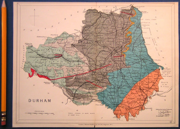
Durham (1913) county geological map from Stanford’s Geological Atlas of Great Britain and Ireland, 3rd edition. Stanford's and Reynolds' Atlases.
Durham (1913) county geological map from Stanford’s Geological Atlas of Great Britain and Ireland, 3rd edition. Approx. 1:350,000 scale. Colour printed map 16.5 x 25cm with centre fold, in good...
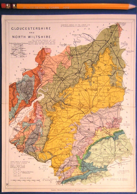
Gloucestershire and North Wiltshire (1913) county geological map from Stanford’s Geological Atlas of Great Britain and Ireland,. Stanford's Atlas.
Gloucestershire and North Wiltshire (1913) county geological map from Stanford’s Geological Atlas of Great Britain and Ireland, 3rd edition. Approx. 1:480,000 scale. Colour printed map 16.5 x 25cm with centre...
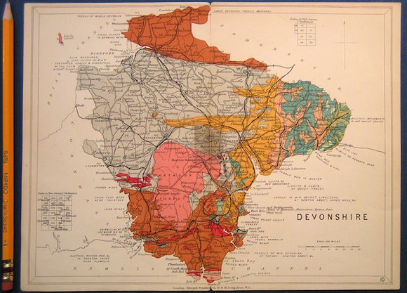
Devon (1913) county geological map from Stanford’s Geological Atlas of Great Britain and Ireland, 3rd edition. Stanford's and Reynolds' Atlases.
Devon (1913) county geological map from Stanford’s Geological Atlas of Great Britain and Ireland, 3rd edition. Approx. 1:640,000 scale. Colour printed map 16.5 x 25cm with centre fold, in good...
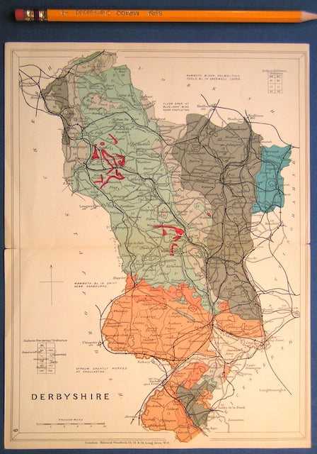
Derbyshire (1913) county geological map from Stanford’s Geological Atlas of Great Britain and Ireland, 3rd edition. Stanford's and Reynolds' Atlases.
Derbyshire (1913) county geological map from Stanford’s Geological Atlas of Great Britain and Ireland, 3rd edition. Approx. 1:480,000 scale. Colour printed map 16.5 x 25cm with centre fold, in good...
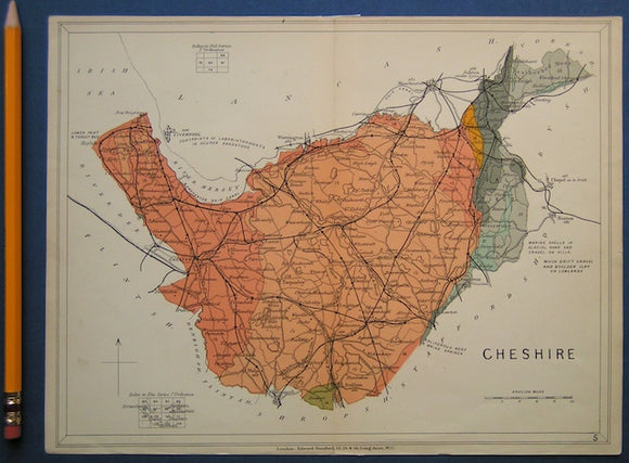
Cheshire (1913) counties geological map from Stanford’s Geological Atlas of Great Britain and Ireland, 3rd edition. Stanford's and Reynolds' Atlases.
Cheshire (1913) counties geological map from Stanford’s Geological Atlas of Great Britain and Ireland, 3rd edition. Approx. 1:480,000 scale. Colour printed map 16.5 x 25cm with centre fold, in good...
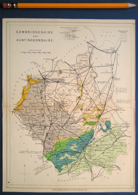
Cambridgeshire and Huntingdonshire (1913) counties geological map from Stanford’s Geological Atlas of Great Britain and Ireland, 3rd edition. Stanford's and Reynolds' Atlases.
Cambridgeshire and Huntingdonshire (1913) counties geological map from Stanford’s Geological Atlas of Great Britain and Ireland, 3rd edition. Approx. 1:480,000 scale. Colour printed map 16.5 x 25cm with centre fold,...