French Geological Maps
Posted by John Henry on
This is the first in a series of articles about new and interesting catalogue entries and background information on a country, or geologist, or topic. This month I’ve started with links to a selection of French maps and invite you browse the Europe - France section for more. If you don't see what you're looking for, please enquire.
Early 19th Century
The first truly geological map is, arguably, the 1810 Carte Géognostique des Environs de Paris by Georges Cuvier (1769-1832) and Alexandre Brongniart (1770-1847). Despite the géognostique of the title, it is much more than a distribution map of mines and quarries as were its precursors. It was published in Cuvier and Brongniart’s 1811 report, Essai sur la Géographie Minéralogique des Environs de Paris.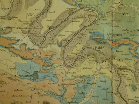
This includes detailed sections and describes the deposits as alternating marine and brackish water environments on the basis of fossil evidence. They recognised that sea levels and or land levels fluctuated. That is, there is a representation of the third dimension and an appreciation of geological time, the fourth dimension.
It is probable that Cuvier and Brongniart were aware of William Smith's contemporary work in England, as Brongniart visited London in 1803 during the interval in the Napoleonic Wars made possible by the Treaty of Amiens. He met Sir Joseph Banks (1743-1820) who, as an early subscriber to Smith’s as yet unpublished map, was certainly aware of Smith’s original concept and would have discussed this exciting development.
The Carte Géologique de la France followed later in 1841. Its authors, Pierre-Armand Dufrénoy (1792-1857) and Léonce Élie de Beaumont (1798-1874), were directed to produce this map of all France by Brochant de Villiers, professor of geology at the École des Mines, in response to the Geological Society of London’s Geological Map of England and Wales, published 1819-20.
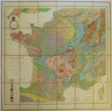
In preparation for it, they visited England in 1823 to meet and travel with George Bellas Greenough, who was editor, compiler, and sponsor of the Geological Society’s map. The Carte Géologique de la France was produced in six sheets to cover France at 1:500,000 with a reduced version at 1:2,000,000 scale.
In parallel with the small scale mapping of France, the 83 départements of France were directed to produce departmental geological maps. There was no standard specification or scale.
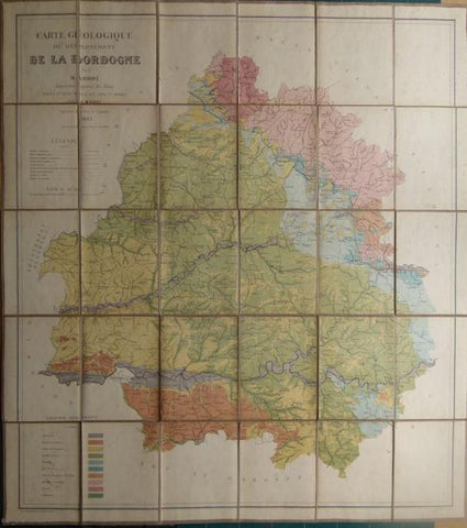
The maps were generally compiled by mining engineers or professors of geology and focus varied - a map might cover a particular resource such as coal or take what became a more conventional stratigraphic approach. The departmental maps were produced between 1825 and 1875 and are included in the French non-survey section of this site.
Later 19th Century
The absence of a systematic national approach led Napoleon III to decree in 1868 that the Carte Géologique Detaillé de la France should be produced by the Ministère des Travaux Publics.
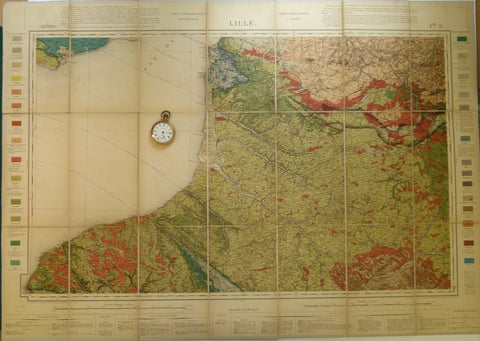
By this time a standard topographic map series at 1:80,000 scale was available for a geological base map, and colour printing had reached a technical standard capable of handling the demands of geological detail and numerous colours. Hand colouring was not adopted as was the contemporary practice in Great Britain. A small scale geological map edition at 1:320,000 was also introduced equivalent to the quarter inch, 1, 253,440, later 1:250,000, small scale maps in the UK. These are listed in the French survey section of this site.
20th Century
In 1959, the Bureau de Recherché Géologiques et Minières (BRGM) implemented a new standard series, the 1:250,000 Carte Géologique de la France and began publishing Carte Géologique Detaillé de la France at the 1:50,000 scale. The 1:80,000 is still issued in a few remaining areas (15 sheets in 2018) not yet covered by 1:50,000 scale.