Free UK postage
H&ASS. Fifeshire (1835 and 1837). Landale, D. Two linked articles on Fife Coalfield. 1. (1835) Portion of the Fife Coalfield, AND Geological Map of the East of Fife Coalfield,. Highland and Agric Soc. Scotland.
H&ASS. Fifeshire (1835 and 1837). Landale, D. Two linked articles on Fife Coalfield. 1. (1835) Portion of the Fife Coalfield, in ‘Report regarding a Portion of the Fife Coal-Field’, an...
Regular price £5400 £54.00
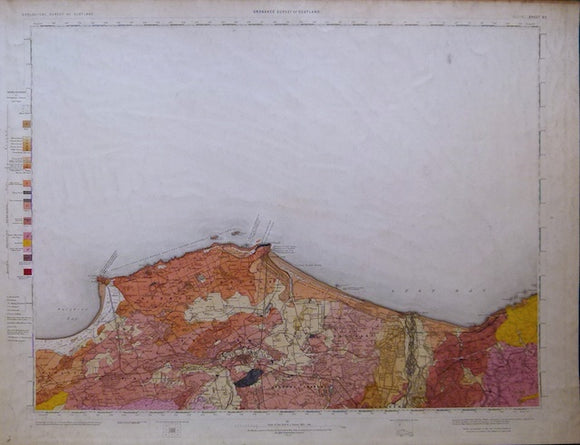
Sheet 95, 1". Elgin, (titled), 1886, 1st edition, issued 1909. Geological Survey of Scotland.
Sheet 95, 1". Elgin, (titled), 1886, 1st edition, issued 1909. 21"x27.5" flat, linen-backed cartridge paper. Topography expressed by contouring. 65% blank as sea. Fochabers on south edge. Coast from Seatown...
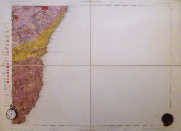
Sheet 67, 1". Stonehaven, (titled), 1898, 1st edition, issued 1898. Geological Survey of Scotland.
Sheet 67, 1". Stonehaven, (titled), 1898, 1st edition, issued 1898. 20.25"x27" cut in four panels, mounted on linen and folded to 10"x13.5 between blue card covers. Topography expressed by hachuring....
Sheet memoir 29 and 37, parts of]. Gunn, W. 1897. The Geology Cowal including the part of Argyllshire Between the Clyde and Loch Fine. Edinburgh: HMSO. British Geological Survey.
Sheet memoir [29 and 37, parts of]. Gunn, W. 1897. The Geology Cowal including the part of Argyllshire Between the Clyde and Loch Fine. Edinburgh: HMSO. 333 pp. + 8...
Regular price £5000 £50.00
Haddingtonshire, 8 (1862)1:10,560 scale OS basemap 1854. Covers Preston Pans together with Haddingtonshire 9 (1862) covering Tranent. British Geological Survey.
Haddingtonshire, 8 (1862)1:10,560 scale OS basemap 1854. Covers Preston Pans. 80% blank as sea or as adjacent county. Legend within blank area. Colour washed engraving, (69.5 x 102cm). Flat, pencilled...
Edinburghshire, 13 (1861)1:10,560 scale OS basemap 1854. Covers Bonnyrigg and Borthwick. Colour washed engraving. British Geological Survey.
Edinburghshire, 13 (1861)1:10,560 scale OS basemap 1854. Covers Bonnyrigg in northeast corner and Borthwick in southwest corner. Colour washed engraving, (69 x 99cm). Flat, minor marginal tears, pencilled library notation...
Sheet memoir 41 and parts of 30, 48 and 49 (1902). Geikie, A. and Peach, B. N. The Geology of Eastern Fife. Memoirs Geological Survey, Scotland. Edinburgh: HMSO. 1st. British Geological Survey.
Sheet memoir 41 and parts of 30, 48 and 49 (1902). Geikie, A. and Peach, B. N. The Geology of Eastern Fife. Memoirs of the Geological Survey, Scotland. Edinburgh: HMSO....
Regular price £4500 £45.00
Memoir Skye (1904). Harker, Alfred The Tertiary Igneous Rocks of Skye. Memoirs of the Geological Survey. British Geological Survey.
Memoir Skye (1904). Harker, Alfred The Tertiary Igneous Rocks of [Central] Skye. Memoirs of the Geological Survey of the United Kingdom. Glasgow: HMSO. 1st edition, 482pp + foldout colour printed...
Sheet memoir 32 and part of 31 (1910). Peach, B. N. et al. The Geology of the Neighbourhood of Edinburgh. MemoirsGeological Survey, Scotland. Edinburgh: HMSO. 2nd. British Geological Survey.
Sheet memoir 32 and part of 31 (1910). Peach, B. N. et al. The Geology of the Neighbourhood of Edinburgh. Memoirs of the Geological Survey, Scotland. Edinburgh: HMSO. 2nd edition,...
Sheet memoir 51 and part of 52 (1930). Richey, J. E., Thomas, H.H. et al. The Geology of Ardnamurchan, North-west Mull and Coll. Memoirs Geological Survey Scotland. Edinburgh: HMSO. 1st. British Geological Survey.
Sheet memoir 51 and part of 52 (1930). Richey, J. E., Thomas, H.H. et al. The Geology of Ardnamurchan, North-west Mull and Coll. Memoirs of the Geological Survey, Scotland. Edinburgh:...
Renfrewshire, 16 and 17 (1870)1:10,560 scale OS basemap 1863. Covers Nelston, New Mearns and Eaglesham. Colour washed engravings. British Geological Survey.
Renfrewshire, 16 (1870)1:10,560 scale OS basemap 1863. Covers Nelston in centre of north half. Colour washed engraving, (68 x 101 cm). Flat, pencilled library notation in bottom right corner, Soiled...
Renfrewshire, 14 and 15 (1874)1:10,560 scale OS basemap 1863. Cover Meikle Millbank and Loch Winnoch. Colour washed engravings. British Geological Survey.
Renfrewshire, 14 (1874)1:10,560 scale OS basemap 1863. Covers Meikle Millbank. Colour washed engraving, (68.5 x 101 cm). Flat, pencilled library notation in bottom right corner, otherwise clean and bright. 85%...
Lanarkshire, 31 (1870)1:10,560 scale OS basemap 1864. Covers Lesmahagow and district. Colour washed engraving,. British Geological Survey.
Lanarkshire, 31 (1870)1:10,560 scale OS basemap 1864. Covers Lesmahagow and district. Colour washed engraving, (69 x 102.5 cm). Flat, pencilled library notation in bottom right corner, otherwise clean and bright....
Fife and Kinross, 35 (1863)1:10,560 scale OS basemap 1855. Covers Dunfermline in southwest corner. Colour washed engraving,. British Geological Survey.
Fife and Kinross, 35 (1863)1:10,560 scale OS basemap 1855. Covers Dunfermline in southwest corner. Colour washed engraving, (70 x 102 cm). Flat, pencilled library notation in bottom right corner, otherwise...
Fife and Kinross, 31 (1868)1:10,560 scale OS basemap 1856. Covers Lochgelly in southwest. Colour washed engraving, (68 x 101.5 cm). Flat, pencilled library notation in bottom right corner, otherwise clean and bright. In very good condition. British Geological Survey.
Fife and Kinross, 31 (1868)1:10,560 scale OS basemap 1856. Covers Lochgelly in southwest. Colour washed engraving, (68 x 101.5 cm). Flat, pencilled library notation in bottom right corner, otherwise clean...
Fife and Kinross, 30 (1865)1:10,560 scale OS basemap 1856. Covers Cleish in northwest. Colour washed engraving, (. British Geological Survey.
Fife and Kinross, 30 (1865)1:10,560 scale OS basemap 1856. Covers Cleish in northwest. Colour washed engraving, (69.5 x 102 cm). Flat, pencilled library notation in bottom right corner, otherwise clean...
Fife and Kinross, 25 (1865)1:10,560 scale OS basemap 1855. Covers Leven on coast. Colour washed engraving,. British Geological Survey.
Fife and Kinross, 25 (1865)1:10,560 scale OS basemap 1855. Covers Leven on coast. Colour washed engraving, (70.5 x 102 cm). Flat, pencilled library notation in bottom right corner, otherwise clean...
Fife and Kinross, 24 (1863)1:10,560 scale OS basemap 1856. Covers Kennoway on east edge and Markinch in centre. Colour washed engraving,. British Geological Survey.
Fife and Kinross, 24 (1863)1:10,560 scale OS basemap 1856. Covers Kennoway on east edge and Markinch in centre. Colour washed engraving, (70 x 101.5 cm). Flat, pencilled library notation in...
Dumbartonshire 23 (1874). 1:10,560 scale OS basemap 1865. Covers Dumtochter, R. Clyde clips southwest corner. Colour washed engraving,. British Geological Survey.
Dumbartonshire 23 (1874). 1:10,560 scale OS basemap 1865. Covers Dumtochter, R. Clyde clips southwest corner. Colour washed engraving, (67.5 x 100 cm). Flat, pencilled library notation in bottom right corner,...
Ayrshire, 50 (1868)1:10,560 scale OS basemap 1860. Covers Dailly and part of Dailly district. Colour washed engraving,. British Geological Survey.
Ayrshire, 50 (1868)1:10,560 scale OS basemap 1860. Covers Dailly and part of Dailly district. Colour washed engraving, (68 5 x 101.5 cm). Flat, pencilled library notation in bottom right corner,...



![Sheet memoir 29 and 37, parts of]. Gunn, W. 1897. The Geology Cowal including the part of Argyllshire Between the Clyde and Loch Fine. Edinburgh: HMSO](http://geolmaps.com/cdn/shop/files/ScotMem_5_Cowal_{width}x.jpg?v=1772969000)
![Sheet memoir 29 and 37, parts of]. Gunn, W. 1897. The Geology Cowal including the part of Argyllshire Between the Clyde and Loch Fine. Edinburgh: HMSO](http://geolmaps.com/cdn/shop/files/ScotMem_5_Cowal_580x.jpg?v=1772969000)


