Free UK postage
Cumberland 18ne, 6". Nether Denton, 1926/1927. Geological Survey of England & Wales.
Cumberland 18se, 6". Hallbankgate, 1901/1927. Black outline and contours with blue geology. Geological Survey of England & Wales.
Cumberland 18sw, 6". Brampton Junction, 1901/1927. Geological Survey of England & Wales.
Cumberland 19sw, 6". Midgeholm, 1901/1927. Black outline and contours with blue geology. Geological Survey of England & Wales.
Cumberland 19sw, 6". Midgeholm, 1946/1954. Black outline and contours with red geology. Geological Survey of England & Wales.
Cumberland 25ne, 6". Cold Fell, 1901/1927. Black outline and contours with blue geology. Geological Survey of England & Wales.
Cumberland 36nw, 6". Aspatria, 1927/1931. Geological Survey of England & Wales.
Cumberland 36sw, 6". Bower Bridge, 1926/1932. Geological Survey of England & Wales.
Cumberland 44ne, 6". Maryport, 1927/1928. Black outline and contours with blue geology. Geological Survey of England & Wales.
Cumberland 45ne, 6". Gilcrux, 1926/1932. Black outline with blue geology and red contours. Geological Survey of England & Wales.
Cumberland 53ne, 6". Clofocks, 1926/1927. Geological Survey of England & Wales.
Cumberland 53nw, 6". River Derwent mouth, 1900/1926. Geological Survey of England & Wales.
Cumberland 53sw, 6". Moss Bay, 1900/1925. Black outline and contours with blue geology. Geological Survey of England & Wales.
Cumberland 54nw, 6". Great Broughton, 1927/1928. Geological Survey of England & Wales.
Cumberland 54sw, 6". Little Clifton, 1926/1928. Geological Survey of England & Wales.
Cumberland 61ne, 6". Harrington, 1900/1926. Black outline and contours with blue geology. Geological Survey of England & Wales.
Cumberland 61nw, 6". Harrington, 1900/1925. Black outline and contours with blue geology. Geological Survey of England & Wales.
Cumberland 61sw, 6". Parton, 1900/1925. Black outline and contours with blue geology. Geological Survey of England & Wales.
Cumberland 72ne, 6". Egremont, 1926/1928. Black outline with blue geology and red contours. Geological Survey of England & Wales.
Cumberland 72se, 6". The Beckermets, 1926/1936. Geological Survey of England & Wales.
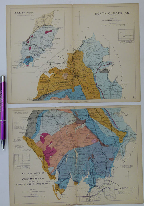
Cumberland, Westmorland counties (Lake District) and Isle of Man (1889) counties geological map from Reynolds’s Geological Atlas of Great Britain, 2nd. Reynolds.
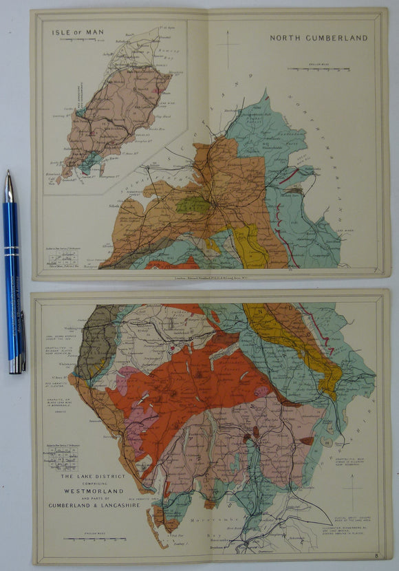
Cumberland, Westmorland counties (Lake District) and Isle of Man (1913) geological map from Stanford’s Geological Atlas of Great Britain and Ireland,. Stanford's and Reynolds' Atlases.
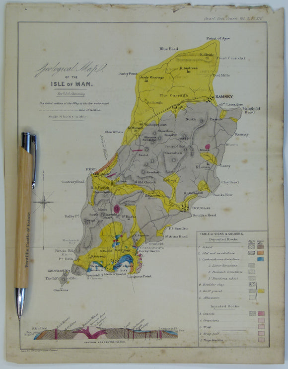
Cummings J.G. (1845). ‘Geological Map of the Isle of Man’ in ‘On the Geology of the Isle of Man’ extract from the Proc Geol Soc. London. V2, pp.317-348. Hand-coloured lithograph,. Geological Society of London.
Cunningham, Frank (1990). James David Forbes; Pioneer Scottish Glaciologist, Edinburgh: Scottish Academic Press, 1st. Scottish Academic Press.