Free UK postage
Hopkins, W. (1847). ‘On the Elevation and Denudation of the District of the Lakes of Cumberland and Westmoreland’, extract from QJGS, v.3, pt.1, pp.70-98 including fold-out hand-coloured geological map,. Geological Society of London.
Hopkins, W. (1847). ‘On the Elevation and Denudation of the District of the Lakes of Cumberland and Westmoreland’, extract from Quarterly Journal of the Geological Society, v.3, pt.1, pp.70-98 including...
Regular price £1500 £15.00
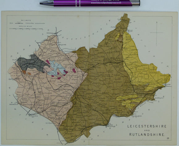
Leicestershire and Rutlandshire (1864) counties geological map from Reynolds’s Geological Atlas of Great Britain, 1st. Reynolds.
Leicestershire and Rutlandshire (1864) counties geological map from Reynolds’s Geological Atlas of Great Britain, 1st edition. Approx. 1:350,000 scale. Hand-coloured map 16.5 x 25cm with centre fold. In good condition....
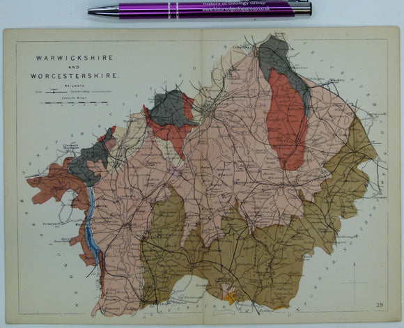
Warwickshire and Worcestershire (1864) counties geological map from Reynolds’s Geological Atlas of Great Britain, 1st. Reynolds.
Warwickshire and Worcestershire (1864) counties geological map from Reynolds’s Geological Atlas of Great Britain, 1st edition. Approx. 1:640,000 scale. Hand-coloured map, 16.5 x 25cm with centre fold. In good condition....
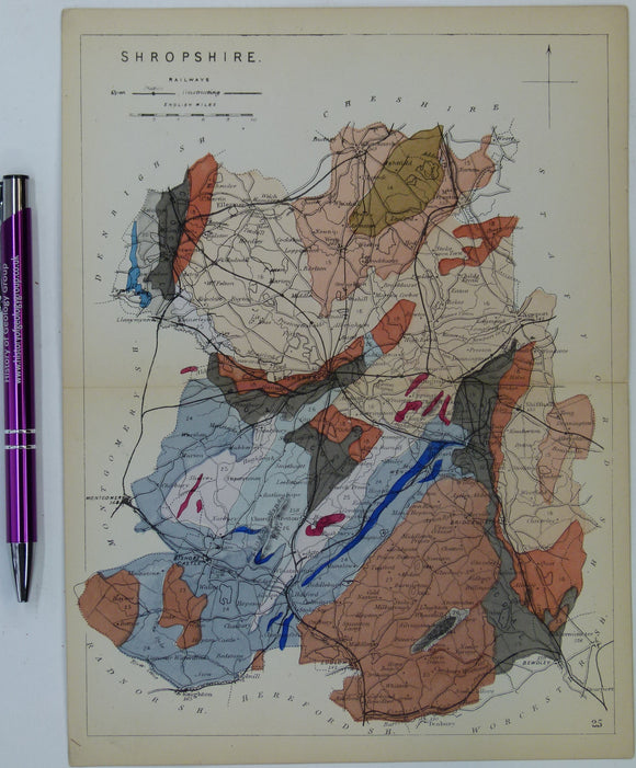
Shropshire (1864) county geological map from Reynolds’s Geological Atlas of Great Britain, 1st edition. Reynolds.
Shropshire (1864) county geological map from Reynolds’s Geological Atlas of Great Britain, 1st edition. Approx. 1:480,000 scale. Hand-coloured map 16.5 x 25cm with centre fold. In good condition. Narrow margins....
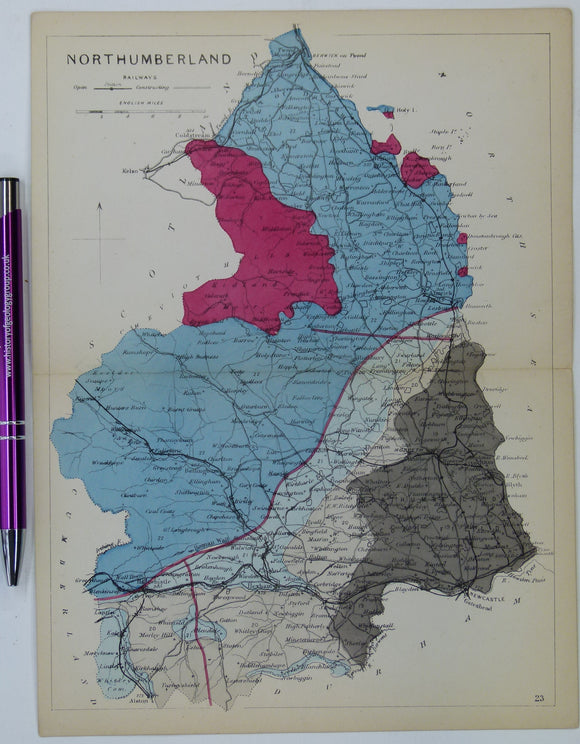
Northumberland (1864) county geological map from Reynolds’s Geological Atlas of Great Britain, 1st edition. Reynolds.
Northumberland (1864) county geological map from Reynolds’s Geological Atlas of Great Britain, 1st edition. Approx. 1:480,000 scale. Hand-coloured map 16.5 x 25cm with centre fold. In good condition. Narrow margins....
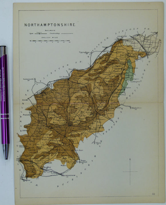
Northamptonshire (1864) county geological map from Reynolds’s Geological Atlas of Great Britain, 1st edition. Reynolds.
Northamptonshire (1864) county geological map from Reynolds’s Geological Atlas of Great Britain, 1st edition. Approx. 1:480,000 scale. Hand-coloured map 16.5 x 25cm with centre fold. In good condition. Narrow margins....
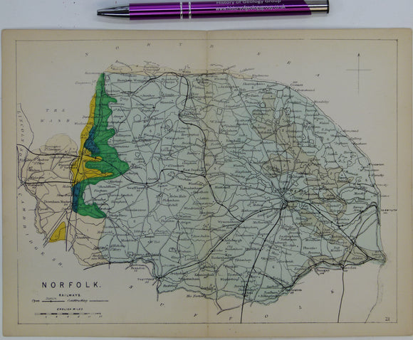
Norfolk (1864) county geological map from Reynolds’s Geological Atlas of Great Britain, 1st edition. Reynolds.
Norfolk (1864) county geological map from Reynolds’s Geological Atlas of Great Britain, 1st edition. Approx. 1:480,000 scale. Hand-coloured map 16.5 x 25cm with centre fold. In good condition. Narrow margins....
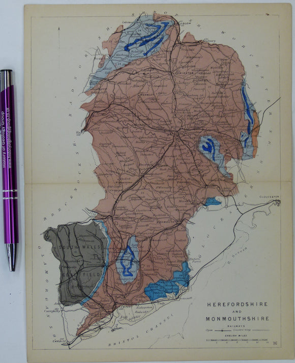
Herefordshire and Monmouthshire (now part of Wales) (1864) counties geological map from Reynolds’s Geological Atlas of Great Britain, 1st. Reynolds.
Herefordshire and Monmouthshire (now part of Wales) (1864) counties geological map from Reynolds’s Geological Atlas of Great Britain, 1st edition. Approx. 1:480,000 scale. Hand-coloured map 16.5 x 25cm with centre...
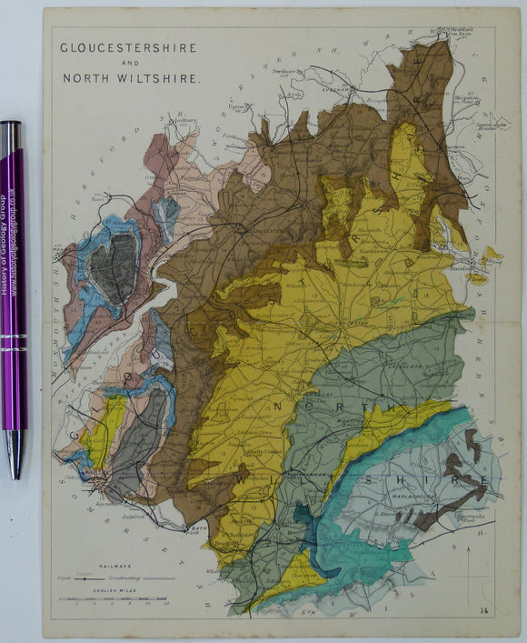
Gloucestershire and North Wiltshire (1864) counties geological map from Reynolds’s Geological Atlas of Great Britain, 1st. Reynolds.
Gloucestershire and North Wiltshire (1864) counties geological map from Reynolds’s Geological Atlas of Great Britain, 1st edition. Approx. 1:480,000 scale. Hand-coloured map 16.5 x 25cm with centre fold. In good...
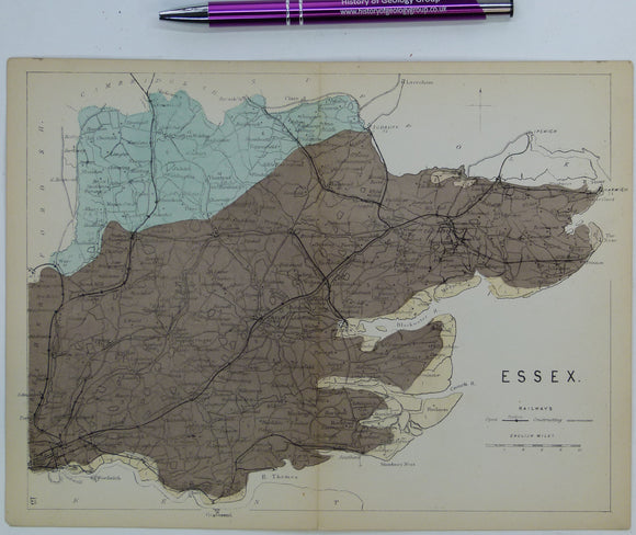
Essex (1864) county geological map from Reynolds’s Geological Atlas of Great Britain, 1st edition. Reynolds.
Essex (1864) county geological map from Reynolds’s Geological Atlas of Great Britain, 1st edition. Approx. 1:480,000 scale. Hand-coloured map 16.5 x 25cm with centre fold. In good condition. Narrow margins....
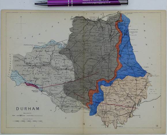
Durham (1864) county geological map from Reynolds’s Geological Atlas of Great Britain, 1st edition. Reynolds.
Durham (1864) county geological map from Reynolds’s Geological Atlas of Great Britain, 1st edition. Approx. 1:350,000 scale. Hand-coloured map 16.5 x 25cm with centre fold. In good condition. Narrow margins....
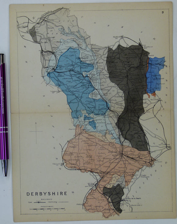
Derbyshire (1864) county geological map from Reynolds’s Geological Atlas of Great Britain, 1st edition. Reynolds.
Derbyshire (1864) county geological map from Reynolds’s Geological Atlas of Great Britain, 1st edition. Approx. 1:480,000 scale. Hand-coloured map 16.5 x 25cm with centre fold. In good condition. Narrow margins....
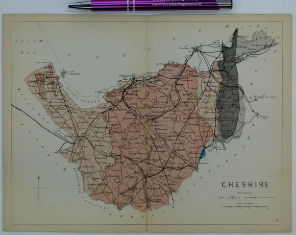
Cheshire (1864) county geological map from Reynolds’s Geological Atlas of Great Britain, 1st edition. Reynolds.
Cheshire (1864) county geological map from Reynolds’s Geological Atlas of Great Britain, 1st edition. Approx. 1:480,000 scale. Hand-coloured map 16.5 x 25cm with centre fold. In good condition. Narrow margins....
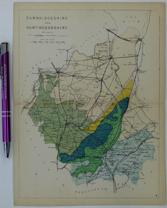
Cambridgeshire and Huntingdonshire (1864) counties geological map from Reynolds’s Geological Atlas of Great Britain, 1st edition. Reynolds.
Cambridgeshire and Huntingdonshire (1864) counties geological map from Reynolds’s Geological Atlas of Great Britain, 1st edition. Approx. 1:480,000 scale. Hand-coloured map 16.5 x 25cm with centre fold. In good condition....
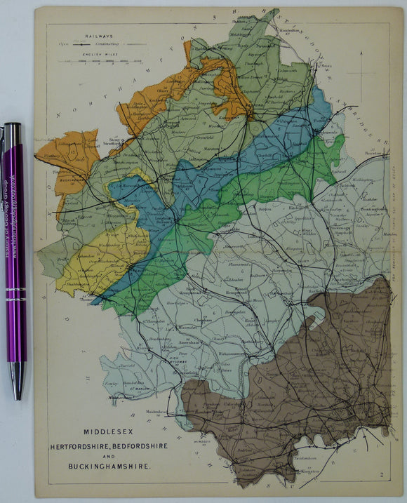
Bedfordshire, Buckinghamshire, Hertfordshire, and Middlesex (1864) counties geological map from Reynolds’s Geological Atlas of Great Britain, 1st edition. Reynolds.
Bedfordshire, Buckinghamshire, Hertfordshire, and Middlesex (1864) counties geological map from Reynolds’s Geological Atlas of Great Britain, 1st edition. Approx. 1:480,000 scale. Hand-coloured map 16.5 x 25cm with centre fold. In...
Garwood, E J. (1931). ‘The Tuedian Beds of North Cumberland and Roxburghshire, East of Liddel Water)’, extract of the QJGS. Geological Society of London.
Garwood, E J. (1931). ‘The Tuedian Beds of North Cumberland and Roxburghshire, East of Liddel Water)’, extract of the Quarterly Journal of the Geological Society, v.87, pp.97-159 + 10 plates,...
Regular price £1400 £14.00
Yorkshire 273 sw. Ingbirchworth. Surveyed 1927, issued 1938. Geological Survey of England & Wales.
Yorkshire 273 sw. Ingbirchworth. Surveyed 1927, issued 1938. Outline geology in black on grey basemap with red contours. Hand coloured 1948. Tape residue on top edge. Torn and soiled. In...
Hampshire 57nw/sw, 6". Chilworth, 1908/1945, joined topographic sheets with central area neatly drawn in ink and hand coloured…. Geological Survey of England & Wales.
Hampshire 57nw/sw, 6". Chilworth, 1908/1945, joined topographic sheets with central area neatly drawn in ink and hand coloured to show the geology of a proposed reservoir. Folded and taped, In fair...
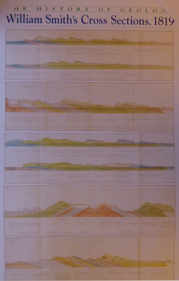
sections, The History of Geology, William Smith’s Cross Sections, 1819. Reproduction. Smith, William.
sections The History of Geology, William Smith’s Cross Sections, 1819. Poster reproducing at approx. 66% reduction of seven sections. 122 x 76.5cm, (48 x 30 in. Publ. jointly by American...
Regular price £1300 £13.00
Mylne, Robert W. (1871). REPRO. Geological Map of London and Its Environs. Reproduction by British Geological Survey. 48 x 69 cm (original size). British Geological Survey.
Mylne, Robert W. (1871). REPRO. Geological Map of London and Its Environs. Reproduction by British Geological Survey. 48 x 69 cm (original size) plus 1.5cm white surplus strip on all...
Regular price £1200 £12.00