Free UK postage
Greece. (c1920). [Geological Map of] Hydra from the series Geological Map of Greece. Geological Survey of Greece.
Greece. (c1920). [Geological Map of] Kythira from the series Geological Map of Greece. Geological Survey of Greece.
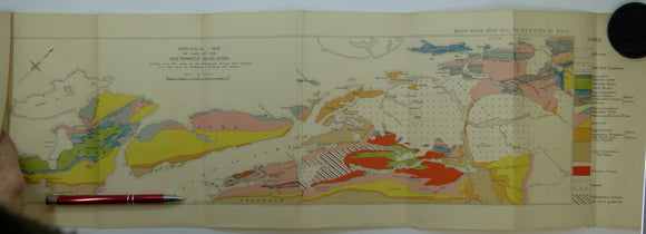
Greece. (c1920). [Geological Maps of] (‘Ap38)Syros and Milos (‘Ap39) Naxos and Amorgos from the series Geological Map of Greece. Geological Survey of Greece.
Greeley, R. and King, J.S. (eds) (1977). Volcanism of the Eastern Snake river Plain, Idaho; A Comparative Planetary Geology Guidebook. Washington: NASA. NASA.
Greeley, R. et al. (eds) (1974). Geologic Guide to the Island of Hawaii; A Field Guide for Comparative Planetary Geology. Washington: NASA , 1st. NASA.
Green, A.H. (1884). First Lessons in Modern Geology. Oxford: Clarendon Press, 1st edition, viii + 212 pp. Hardback presentation copy. Clarendon Press.
Green, A.H. (1884). First Lessons in Modern Geology. Oxford: Clarendon Press, 1st edition, viii + 212 pp. Hardback presentation copy,. Clarendon Press.
Green, J.F.N. (1923). ‘The Structure of the Bowmore-Portaskaig District to Islay’, extract from the QJGS, v.79. Geological Society of London.
Green, J.F.N. (1931). ‘The South-West Highland Sequence’, extract from the Quarterly Journal of the Geological Society, v.87,. Geological Society of London.
Green, John FN., (1923). ‘Map of the Country about Bridgend (Islay)’. Fold-out colour printed geological map, 1:31,860. QJGS.
Green, John FN., (1931), ‘Geological Map of part of the Southwest Highlands’. Fold-out colour printed geological map,. QJGS.
Greene, Mott T. (1982). Geology in the Nineteenth Century; Changing Views of a Changing World. Ithaca: Cornell University Press, 324pp. Hardback,. Cornell University Press.
Greenland (c1970).Quaternary Map of Greenland. Copenhagen: Geological Survey of Greenland, 1:2,500,000 scale. 112 x 83cm. Linen-backed colour print
Greenland (c1970).Tectonic/Geological Map of Greenland. Copenhagen: Geological Survey of Greenland, 1:2,500,000 scale. 114 x 85 cm. Geological Survey of Greenland.
Greenland. Preliminary Geological Map of the Agto-Nordre Stromfjord Region (1970). Geological Survey of Greenland. Folded b/w map, 1:200,000. Geological Survey of Greenland.
Greenland. Preliminary Geological Map of the Fiskenaesset Region (1972). Geological Survey of Greenland. Folded b/w map, 1:100,000. Geological Survey of Greenland.
Greenland. Tectonic / Geological Map of Greenland (1970). Geological Survey of Greenland. Folded colour printed map, 1:2,500,000. Geological Survey of Greenland.
Greensmith, JT, and Tooley, MJ. (eds) (1982). Sea-Level Movements during the last deglacial hemicycle (about 15,000 years). London: G.A.’. Geologists' Association.
Gregory KJ and Ravenhill, WLD (1971). Exeter Essays in Geography in honour of Arthur Davies. Includes the origins of official geological mapping in Devon and Cornwall. university of exeter.
Gregory, JW (1906). ‘The Geological Plans of Some Australian Mining-Fields’ off print from Science Progress, no.1, July 1906. 20pp. Paperback,. Science Progress.
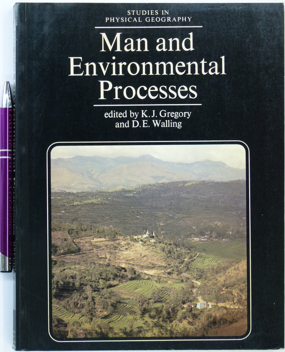
Gregory, KJ and Walling, DE. (eds) (1981). Man and Environmental Processes. London: Butterworths. 1st edn. Butterworth.
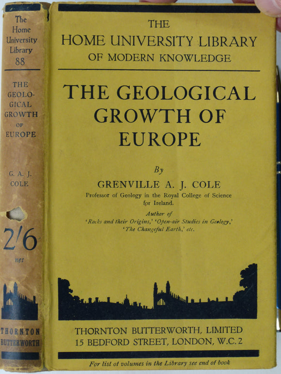
Grenville AJ Cole (1935). The Geological Growth of Europe. London: Thornton Butterworth. 3rd impression. 1st published in 1914. Thornton and Butterworth.
Grew, E.S. (1911). The Romance of Modern Geology; ... the making of the earth, with some account of prehistoric animal life. London: Seeley, 1st edition. Seeley.
Gribble, C.D. (ed) (1976). Ardnamurchan, a Guide to Geological Excursions. Edinburgh Geological Society,1st edition,122pp. + map. Edinburgh Geological Society.
![Greece. (c1920). [Geological Map of] Hydra from the series Geological Map of Greece](http://geolmaps.com/cdn/shop/files/Agean_14_33c58443-7831-477d-8248-2aaec166aaa2_{width}x.jpg?v=1775049453)
![Greece. (c1920). [Geological Map of] Hydra from the series Geological Map of Greece](http://geolmaps.com/cdn/shop/files/Agean_14_33c58443-7831-477d-8248-2aaec166aaa2_580x.jpg?v=1775049453)
![Greece. (c1920). [Geological Map of] Kythira from the series Geological Map of Greece](http://geolmaps.com/cdn/shop/files/Agean_11_{width}x.jpg?v=1775036206)
![Greece. (c1920). [Geological Map of] Kythira from the series Geological Map of Greece](http://geolmaps.com/cdn/shop/files/Agean_11_580x.jpg?v=1775036206)
![Greece. (c1920). [Geological Maps of] (‘Ap38)Syros and Milos (‘Ap39) Naxos and Amorgos from the series Geological Map of Greece](http://geolmaps.com/cdn/shop/files/Agean_1_{width}x.jpg?v=1775035435)
![Greece. (c1920). [Geological Maps of] (‘Ap38)Syros and Milos (‘Ap39) Naxos and Amorgos from the series Geological Map of Greece](http://geolmaps.com/cdn/shop/files/Agean_1_580x.jpg?v=1775035435)