Free UK postage
Geikie, A. (1897). The Ancient Volcanoes of Great Britain, London: MacMillan, 2 vols. V.1, xiv + 477 pp. V2. xv + 492pp. Hardback. MacMillan.
Geikie, A. (1904). Scottish Reminiscences. Glasgow: James Maclehose.1st reprint of 1st edition. James Maclehose.
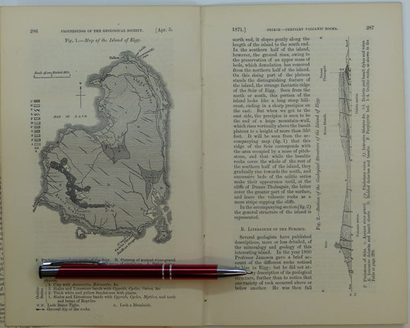
Giekie, Archibald, (1871), ‘Map of the Island of Eigg. b/w geological map, 1:63,360,. QJGS.
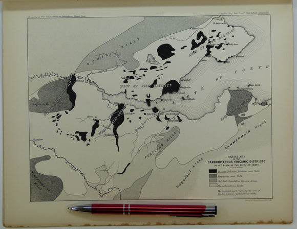
Giekie, Archibald, (1879), ‘On the Carboniferous Volcanic Rocks of the Basin of the Firth of Forth: their Structure in the Field. Royal Society of Edinburgh.
Green, J.F.N. (1923). ‘The Structure of the Bowmore-Portaskaig District to Islay’, extract from the QJGS, v.79. Geological Society of London.
Green, J.F.N. (1931). ‘The South-West Highland Sequence’, extract from the Quarterly Journal of the Geological Society, v.87,. Geological Society of London.
Green, John FN., (1923). ‘Map of the Country about Bridgend (Islay)’. Fold-out colour printed geological map, 1:31,860. QJGS.
Green, John FN., (1931), ‘Geological Map of part of the Southwest Highlands’. Fold-out colour printed geological map,. QJGS.
Gribble, C.D. (ed) (1976). Ardnamurchan, a Guide to Geological Excursions. Edinburgh Geological Society,1st edition,122pp. + map. Edinburgh Geological Society.
Harker, A. (1941) The West Highlands and the Hebrides; a Geologist’s Guide for Amateurs. Cambridge University Press, 1st edition. Cambridge University Press.
Haswell-Smith, Hamish (1996). The Scottish Islands; a Comprehnsive Guide to Every Scottish Island. Edinburgh, Canongate. 423 pp. 1st edition. Canongate.
Hill, Julian. (n.d.). Reading the Landscape of Bute through its Geology. Rothesay; Bute Newspapers, 1st edition, 83 pp. Paperback. WEA.
Jamieson, Thomas F., (1863). ‘Sketch-Map of a part of of Lochaber’. Fold-out colour printed map, 1:253,440. QJGS.
Jehu, T.J. (1922). The Archaean and Torridonian formations and the Later Intrusive Igneous Rocks of Iona. Edinburgh: Royal Society. Royal Society of Edinburgh.
Johnson, M.R.W. (1957). ‘The Tectonic Phenomena associated with the Post-Cambrian Thrust Movements at Coulin, Wester Ross’, offprint of the QJGS. Geological Society of London.
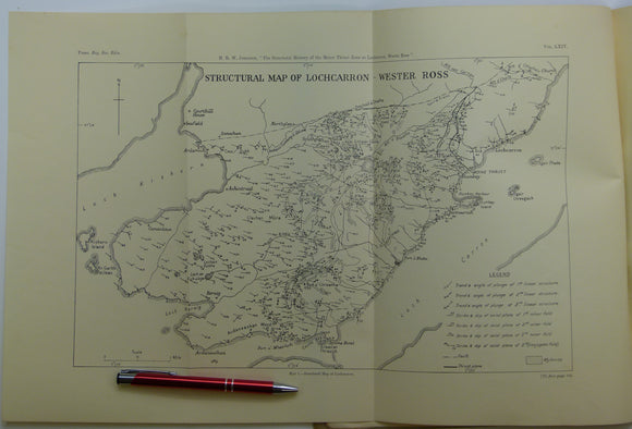
Johnson, MRW., (1960), ‘Geological Map of the Geology Lochcarron - Wester Ross’, B/w printed map, 1:31,680. Royal Society of Edinburgh.
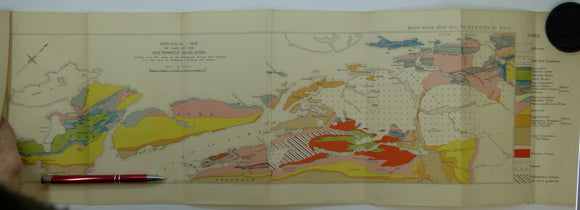
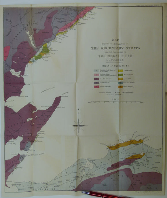
Judd, J.W. (1873). [Geological] Map Showing ... the Secondary Strata Around the Moray Firth [Scotland], fold-out colour printed map,. Geological Society of London.
Judd, John W., (1873), ‘Map Showing the Secondary Strata around the Shores of the Moray Firth. Fold-out colour printed geological map. QJGS.
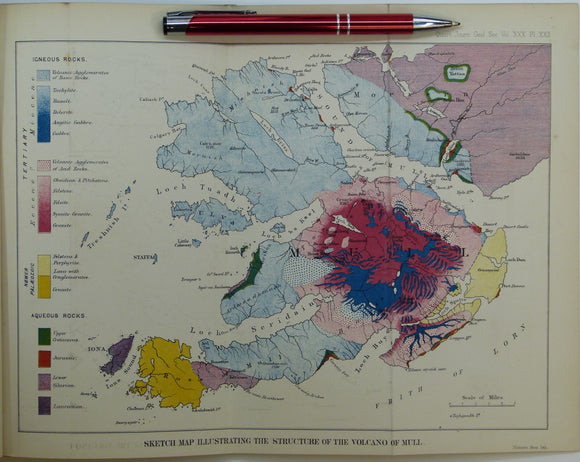
Judd, John W., (1874), ‘Sketch Map Illustrating the Structure of the Volcano of Mull. Fold-out colour printed geological map. QJGS.
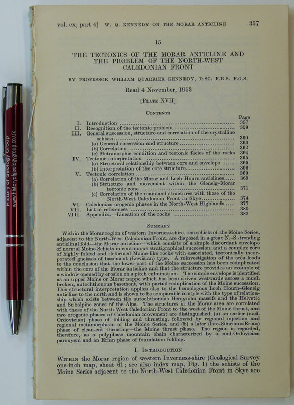
Kennedy, Wm. Q. (1955). ‘Geological Map of the Morar Anticline, West Inverness-shire’, fold-out b/w map with sections,. Geological Society of London.
Macculloch, John (1819). ‘Geological Map] Rum, Egg, Muck’, extract from A Description of the Western Islands of Scotland,. Constable and Co.
Macculloch, John (1819). ‘[Geological Map of the Islands of] Mull, Iona, Staffa’, extract from A Description of the Western Islands of Scotland. Constable and Co.
Macculloch, John (1819). ‘[Geological Maps of the Islands of] Bute and Cumbray, and of Giga and Cara ’, extract from A Description of the Western Islands of Scotland,. Constable and Co.
Macculloch, John (1819). ‘[Geological Maps of the Islands of] Staffa, St. Kilda’, extract from A Description of the Western Islands of Scotland,. Constable and Co.


![Judd, J.W. (1873). [Geological] Map Showing ... the Secondary Strata Around the Moray Firth [Scotland], fold-out colour printed map,](http://geolmaps.com/cdn/shop/products/Judd2ndryScotland_1_{width}x.jpg?v=1619627314)
![Judd, J.W. (1873). [Geological] Map Showing ... the Secondary Strata Around the Moray Firth [Scotland], fold-out colour printed map,](http://geolmaps.com/cdn/shop/products/Judd2ndryScotland_1_580x.jpg?v=1619627314)


![Macculloch, John (1819). ‘Geological Map] Rum, Egg, Muck’, extract from A Description of the Western Islands of Scotland,](http://geolmaps.com/cdn/shop/products/RumEggMuck_1_{width}x.jpg?v=1652358140)
![Macculloch, John (1819). ‘Geological Map] Rum, Egg, Muck’, extract from A Description of the Western Islands of Scotland,](http://geolmaps.com/cdn/shop/products/RumEggMuck_1_580x.jpg?v=1652358140)
![Macculloch, John (1819). ‘[Geological Map of the Islands of] Mull, Iona, Staffa’, extract from A Description of the Western Islands of Scotland](http://geolmaps.com/cdn/shop/products/MullIonaetal1_{width}x.jpg?v=1652358353)
![Macculloch, John (1819). ‘[Geological Map of the Islands of] Mull, Iona, Staffa’, extract from A Description of the Western Islands of Scotland](http://geolmaps.com/cdn/shop/products/MullIonaetal1_580x.jpg?v=1652358353)
![Macculloch, John (1819). ‘[Geological Maps of the Islands of] Bute and Cumbray, and of Giga and Cara ’, extract from A Description of the Western Islands of Scotland,](http://geolmaps.com/cdn/shop/products/ButeGigha_1_{width}x.jpg?v=1652358884)
![Macculloch, John (1819). ‘[Geological Maps of the Islands of] Bute and Cumbray, and of Giga and Cara ’, extract from A Description of the Western Islands of Scotland,](http://geolmaps.com/cdn/shop/products/ButeGigha_1_580x.jpg?v=1652358884)
![Macculloch, John (1819). ‘[Geological Maps of the Islands of] Staffa, St. Kilda’, extract from A Description of the Western Islands of Scotland,](http://geolmaps.com/cdn/shop/products/StaffaStKilda1_{width}x.jpg?v=1652358483)
![Macculloch, John (1819). ‘[Geological Maps of the Islands of] Staffa, St. Kilda’, extract from A Description of the Western Islands of Scotland,](http://geolmaps.com/cdn/shop/products/StaffaStKilda1_580x.jpg?v=1652358483)