Free UK postage
Assmann, P. (ed.) et al (1957). [The geological structure of Berlin]. Der geologische Aufbau der Gegend von Berlin Ministry of Construction. 111pp with folded map and section. Assmann, P et al.
Belfast District, Drift, (1901). First edition. Colour print, flat, 45 x 61cm. Scale 1:63,360. Base map 1903. Geological Survey of Ireland.
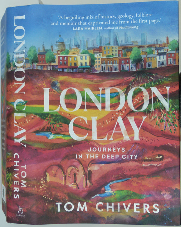
Chivers, Tom (2021). London Clay; Journeys in the Deep City. London: Doubleday, 449pp. Hardback. Doubleday.
Clayton, Antony (2000). Subterranean City: Beneath the Streets of London. Whitstable: Historical Publications.1st edition,. Historical Publications.
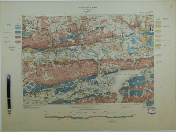
Cork District, Drift, (1903). First edition. Colour print, flat, 45 x 60.5cm. Scale 1:63,360. Base map 1899. Geological Survey of Ireland.
Czizek Johann Bapt. (1847). Geognostiche Karte Ungebunen Wien’s [Vienna, Austria]. Reproduction. 1 inch to a mile approx. self published.
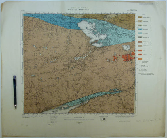
Killarney & Kenmare District, (1913). First edition. Colour print, flat, 56 x 68.5cm. Scale 1:63,360. Base map 1910. Geological Survey of Ireland.
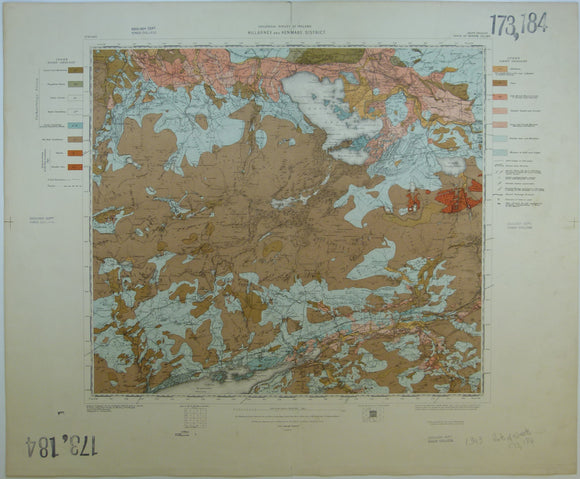
Killarney & Kenmare District, Drift, (1913). First edition. Colour print, flat, 56 x 68.5cm. Scale 1:63,360. Base map 1910. Geological Survey of Ireland.
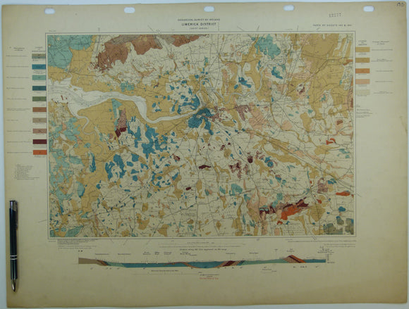
Limerick District, Drift, (1904). First edition. Colour print, flat, 46 x 60.5cm. Scale 1:63,360. Base map 1899. Geological Survey of Ireland.
London. (1880). Wyld’s Map of the Superficial Geology of London and Environs. London: James Wyld. Colour lithograph 1:63,360. Wyld, James, jr..
London. Jordan, J. B. and Whitaker, W. (1894). Stanford’s Geological Map of London: Shewing Superficial Deposits. London: Edward Stanford. 3rd ed. Stanford.
London. Jordan, J. B. and Whitaker, W. (c1906). Stanford’s Geological Map of London: Shewing Superficial Deposits. London: Edward Stanford. 3rd ed. Stanford.
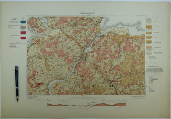
Londonderry District, Drift, (1908). First edition. Colour print, flat, 46 x 66cm. Scale 1:63,360. Geological Survey of Ireland.
Mylne, Robert W. (1871). REPRO. Geological Map of London and Its Environs. Reproduction by British Geological Survey. 48 x 69 cm (original size). British Geological Survey.
Robinson, Eric (1984). London: Illustrated Geological Walks. Edinburgh: Scottish Academic Press for Geologists’ Association.98pp. Geologists' Association.
Rosen, Dennis and Sylvia (1994). London Science: Museums, libraries, and places of scientific, technological & medical interest. London,. Prion.
Sheet memoir 256, 257, 270, 271 (2004). Geology of London. Ellison, R. et al. London: British Geological Survey. 1st. British Geological Survey.
Sheet memoir 256, 257, 270, 271 (2004). Geology of London. Ellison, R. et al. London: British Geological Survey. 1st edition. British Geological Survey.
Sollas, W.J. (1893). ‘The Geology of Dublin and its Neighbourhood’. London: Geologists’ Association. Reprint from Proc GA. Geologists' Association.
Sussex. Venebles, E.M. and Outen, A. F. (1969). Building Stones of Old Bognor. Bognor Regis: B.R. Natural Science Society Publications. 20pp. Bognor Regis Soc.
Trench, Richard and Hillman, Ellis (1985). London under London: a Subterranean Guide. London: John Murray, 1st edition,. John Murray.
Walker, Henry (1871). Saturday Afternoon Rambles Round London; Rural and Geological Sketches. Hodder and Stoughton.
Walker, Henry (1871). Saturday Afternoon Rambles Round London; Rural and Geological Sketches. London:. Hodder and Stoughton.
Whitaker, William. (1875-1901). The Geology of London. Memoir of the Geological Survey. London: HMSO. Sammelband volume of several paperback editions. British Geological Survey.
![Assmann, P. (ed.) et al (1957). [The geological structure of Berlin]. Der geologische Aufbau der Gegend von Berlin Ministry of Construction. 111pp with folded map and section.](http://geolmaps.com/cdn/shop/files/Berlin_1_{width}x.jpg?v=1739019722)
![Assmann, P. (ed.) et al (1957). [The geological structure of Berlin]. Der geologische Aufbau der Gegend von Berlin Ministry of Construction. 111pp with folded map and section.](http://geolmaps.com/cdn/shop/files/Berlin_1_580x.jpg?v=1739019722)


![Czizek Johann Bapt. (1847). Geognostiche Karte Ungebunen Wien’s [Vienna, Austria]. Reproduction. 1 inch to a mile approx.](http://geolmaps.com/cdn/shop/files/ViennabyCzjzek1847_1_{width}x.jpg?v=1764506417)
![Czizek Johann Bapt. (1847). Geognostiche Karte Ungebunen Wien’s [Vienna, Austria]. Reproduction. 1 inch to a mile approx.](http://geolmaps.com/cdn/shop/files/ViennabyCzjzek1847_1_580x.jpg?v=1764506417)