Free UK postage
Ireland sheet 7, Giant’s Causeway, 1” scale. 1887. 1st ed. Covers Portrush and Ballin. 55% sea. Base map 1865. Hand-coloured. Geological Survey of Ireland.
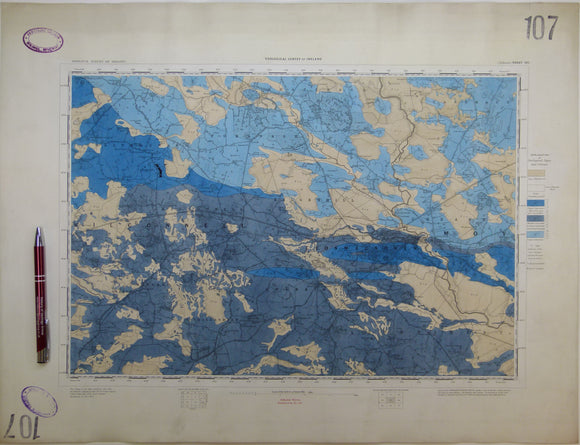
Ireland sheet 107, Ballinasloe, 1” scale. 1867. First edition. Base map not dated. Coloured 1903. Hand-coloured
Ireland sheet 11, Londonderry, 1” scale. 1890. First edition. Covers Rathmelton and Buncrana. Base map 1863. Hand-coloured. Geological Survey of Ireland.
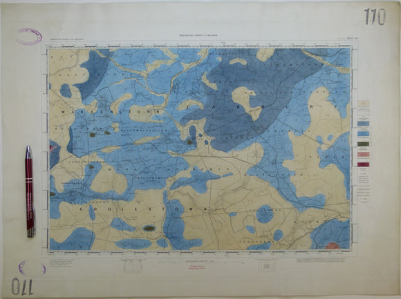
Ireland sheet 110, Edenderry, 1” scale. 1864. First edition. Base map not dated. Hand-coloured engraving,. geo.
Ireland sheet 13, Coleraine, 1” scale. 1883. First edition. Covers Garvagh, Ballymoney. Base map 1867. Hand-coloured. Geological Survey of Ireland.
Ireland sheet 19, Maghera, 1” scale. 1882. First edition. Covers Kilrea, Ahoghill, Portglenone. Base map 1868. Geological Survey of Ireland.
Ireland sheet 19, Maghera, 1” scale. 1882. First edition. Covers Kilrea, Ahoghill, Portglenone. Base map 1868. Hand-coloured. Geological Survey of Ireland.
Ireland sheet 20, Ballymena, 1” scale. 1883. First edition. Covers to northeast coast from Ballymena. coloured 1904. Geological Survey of Ireland.
Ireland sheet 21, Larne, 1” scale. 1869. First edition. Covers to Lough Larne, 85% sea. Base map undated. Hand-coloured. Geological Survey of Ireland.
Ireland sheet 21, Larne, 1” scale. 1883. Covers to Lough Larne, 85% sea. Base map undated. Hand-coloured. Geological Survey of Ireland.
Ireland sheet 26, Draperstown, 1” scale. 1882. First edition. Base map 1870. Hand-coloured engraving. Geological Survey of Ireland.
Ireland sheet 27, Cookstown, 1” scale. 1880. First edition. Base map 1867. Covers NW of Lough Neagh. Hand -coloured. Geological Survey of Ireland.
Ireland sheet 28, 29, 36, 37 drift, 1". Belfast Special Sheet, 1910. Colour print, 30.5 x 46.5cm,. Geological Survey of Ireland.
Ireland sheet 28, Antrim, 1” scale. 1874. First edition. Base map 1864. Covers NE of Lough Neagh. Hand -coloured. Geological Survey of Ireland.
Ireland sheet 29, Carrickfergus, 1” scale. 1883. Base map 1864. Covers entrance to Belfast Lough,. Geological Survey of Ireland.
Ireland sheet 35, Dungannon, 1” scale. 1875. First edition. Covers Stewartstown, SW Lough Neagh. Hand-coloured. Geological Survey of Ireland.
Ireland sheet 36, Belfast, 1” scale. 1876. Covers Lisburn, Hillsborough, SE Lough Neagh. Base map 1864. Hand-coloured. Geological Survey of Ireland.
Ireland sheet 37, Newtown Ards, 1” scale. 1898. Covers Saintfield, Strangford Lough. Base map not dated. Hand-coloured. Geological Survey of Ireland.
Ireland sheet 38, no title - Burial Island, 1” scale. 1878. 95% sea. Base map 1868, coloured 1905. Hand-coloured. Geological Survey of Ireland.
Ireland sheet 39, no title – Erris Head, 1” scale. 1900. 98% sea. Base map not dated, coloured 1905. Hand-coloured. Geological Survey of Ireland.