Free UK postage
Ireland sheet 40, no title – Benwee Head, 1” scale. 1877. 80% sea. Base map 1869. Hand-coloured engraving,. Geological Survey of Ireland.
Ireland sheet 41, no title – Downpatrick Head, 1” scale. 1872. 90% sea. Base map 1869. Hand-coloured. Geological Survey of Ireland.
Ireland sheet 42, no title – Sligo Bay, 1” scale. 1883. First edition. 90% sea. Base map 1868. Hand-coloured. Geological Survey of Ireland.
Ireland sheet 44, Derrygonelly, 1” scale. 1894. First edition. Covers Lough Macnean Upper. Base map 1876. Hand-coloured. Geological Survey of Ireland.
Ireland sheet 45, Enniskillen, 1” scale. 1881. First edition. Covers Brookeborough, Macguire’s Bridge. Hand-coloured. Geological Survey of Ireland.
Ireland sheet 46, Clogher, 1” scale. 1901. Covers Glaslough, Caledon. Base map 1877. Hand-coloured. Geological Survey of Ireland.
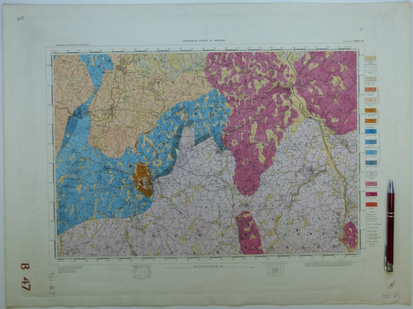
Ireland sheet 47, Armagh, 1” scale. 1873. Covers Portadown, Pointzpass. Base map undated. Hand-coloured. Geological Survey of Ireland.
Ireland sheet 47, Armagh, 1” scale. 1873. Covers Portadown, Pointzpass. Base map undated. Hand-coloured
Ireland sheet 48, Banbridge, 1” scale. 1901. Covers Bromore, Ballymahinch. Base map not dated. Coloured 1904. Hand-coloured. Geological Survey of Ireland.
Ireland sheet 48, Banbridge, 1” scale. 1901. Covers Bromore, Ballymahinch. Base map not dated. Hand-coloured. Geological Survey of Ireland.
Ireland sheet 49, Downpatrick, 1” scale. 1901. Covers Killyleagh, lower Strangford Lough. Base map not dated. Hand-coloured. Geological Survey of Ireland.
Ireland sheet 50, untitled – North and South Rocks, 1” scale. 1900. 99% sea. Base map undated. Hand-coloured. Geological Survey of Ireland.
Ireland sheet 51, Belmullet, 1” scale. 1878. First edition. Covers Inishkea Islands. 50% sea. Base map 1871. Hand-coloured. Geological Survey of Ireland.
Ireland sheet 52, untitled – Carrowmore Lake, 1” scale. 1879. First edition. Extensive bog. Base map 1872. Hand-coloured. Geological Survey of Ireland.
Ireland sheet 53, Killala, 1” scale. 1876. First edition. Base map 1874. Hand-coloured engraving,. Geological Survey of Ireland.
Ireland sheet 54, Coolaney, 1” scale. 1876. First edition. Base map 1874. Coloured 1906. Hand-coloured. Geological Survey of Ireland.
Ireland sheet 58, Monaghan, 1” scale. 1880. First edition. Covers Clones, Ballybay. Hand-coloured. Geological Survey of Ireland.
Ireland sheet 58, Monaghan, 1” scale. 1911. Covers Clones, Ballybay. Base map not dated. Hand-coloured. Geological Survey of Ireland.
Ireland sheet 59, Castleblayney, 1” scale. 1901. Covers CastleWellan, Slievebingian. Base map 1874. Hand-coloured. Geological Survey of Ireland.
Ireland sheet 60, Newry, 1” scale. 1901. Covers Keady, Slieve Gullion. Base map 1874. Coloured 1905. Hand-coloured. Geological Survey of Ireland.
Ireland sheet 60, Newry, 1” scale. 1901. Covers Keady, Slieve Gullion. Base map 1874. Hand-coloured. Geological Survey of Ireland.
Ireland sheet 61, Ardglass, 1” scale. 1901. Covers Dundrum, Annalong. Base map not dated. Hand-coloured. Geological Survey of Ireland.
Ireland sheet 64, Baleena, 1” scale. 1878. First edition. Includes Loughs Conn and Cullin. Base map 1874. Hand-coloured. Geological Survey of Ireland.