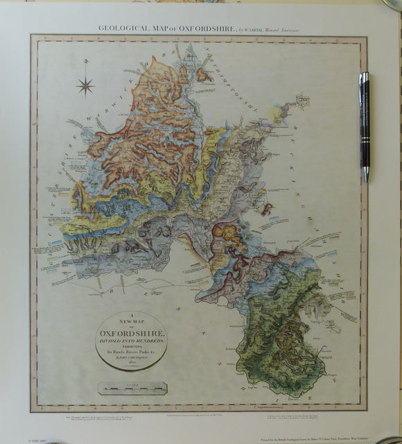
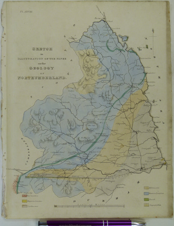
Wood, N. (1831). ‘On the Geology of a part of Northumberland and Cumberland’ extract from Trans. Nat. Hist. Soc. Northumberland, Durham & Newcastle upon Tyne, 1831. v1, pp 302-334 + 3 plates. Trans Northum, Durham, Newcastle.
Regular price
£7500
£75.00


![Wetherell, Nathaniel Charles (1838) ‘Observations on a Well dug on the South Side of Hampstead Heath [London]’,](http://geolmaps.com/cdn/shop/products/HampsteadwellWetherell_1_{width}x.jpg?v=1612437996)
![Wetherell, Nathaniel Charles (1838) ‘Observations on a Well dug on the South Side of Hampstead Heath [London]’,](http://geolmaps.com/cdn/shop/products/HampsteadwellWetherell_1_580x.jpg?v=1612437996)


![Wright, Romley (1838). 'Plan & Section from the Brown Clee Hill, in the County of Salop [Shropshire]'](http://geolmaps.com/cdn/shop/products/BrownCleeHill_1_{width}x.jpg?v=1614447864)
![Wright, Romley (1838). 'Plan & Section from the Brown Clee Hill, in the County of Salop [Shropshire]'](http://geolmaps.com/cdn/shop/products/BrownCleeHill_1_580x.jpg?v=1614447864)

![[Geological Maps of] The Coal Fields of Westphalia and The Coal Fields of Bohemia, 1869, Plate 10, from Mines and Miners; or, Underground Life by L. Simonin](http://geolmaps.com/cdn/shop/products/P1080650_{width}x.JPG?v=1551270987)
![[Geological Maps of] The Coal Fields of Westphalia and The Coal Fields of Bohemia, 1869, Plate 10, from Mines and Miners; or, Underground Life by L. Simonin](http://geolmaps.com/cdn/shop/products/P1080650_580x.JPG?v=1551270987)
![[Geological] Map of the Coal Fields of Durham and Northumberland and Cumberland, 1869, Plate 4, from Mines and Miners; or, Underground Life by L. Simonin](http://geolmaps.com/cdn/shop/products/P1080645_{width}x.JPG?v=1551270123)
![[Geological] Map of the Coal Fields of Durham and Northumberland and Cumberland, 1869, Plate 4, from Mines and Miners; or, Underground Life by L. Simonin](http://geolmaps.com/cdn/shop/products/P1080645_580x.JPG?v=1551270123)
![[Geological] Map of the Coal Fields of the United States, New Brunswick and Nova-Scotia, 1869, Plate 8, from Mines and Miners; or, Underground Life by L. Simonin](http://geolmaps.com/cdn/shop/products/P1080649_{width}x.JPG?v=1551270902)
![[Geological] Map of the Coal Fields of the United States, New Brunswick and Nova-Scotia, 1869, Plate 8, from Mines and Miners; or, Underground Life by L. Simonin](http://geolmaps.com/cdn/shop/products/P1080649_580x.JPG?v=1551270902)