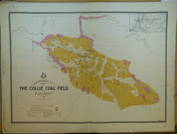
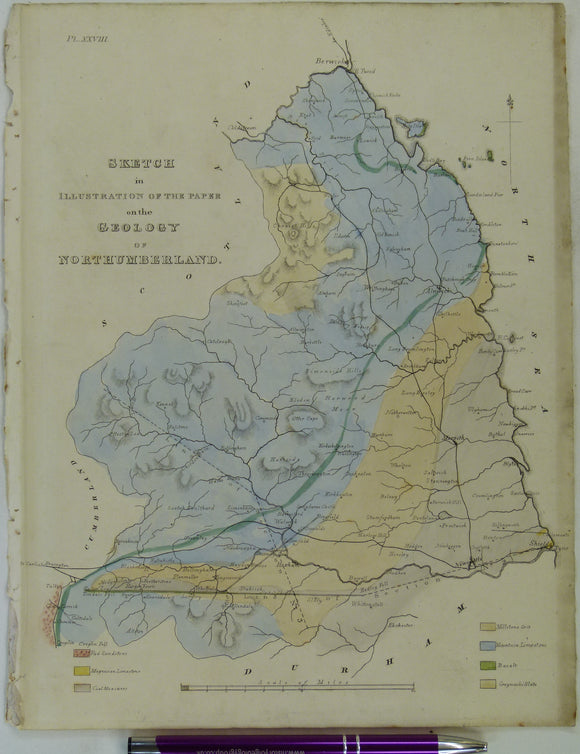
Free UK postage
Sheet 75, Rennes, Carte Geologique Détaillée-Rennes,1893. Scale 1:160,000. Bureau de Researches Geologiques et Minieres.
Sheet 8, Lille, Carte Géologique de, 1897, 1:320,000 scale. Base map 1852. French Geological Survey.
Sheet Memoir 112-113 (parts), 82se Old Series (1879). The Geology of parts of Nottinghamshire and Derbyshire, by Aveline, W.T. British Geological Survey.
Sheet Memoir 125. Geology of the Carboniferous Limestone, Yoredale Rocks and Millstone Grit of North Derbyshire, by Green…. Geological Survey of England & Wales.
Sheet Memoir 249. Newport (Geology of the South Wales Coalfield, part I), by Strahan, A. 1899. First edition.
Sheet Memoir 249. Newport (Geology of the South Wales Coalfield, part I), by Strahan, A. 1909. Second edition.
Sheet Memoir 328, 329, 332, 334. 4 old series reports bound in one volume, all 1st editions by Reid, C. Dorchester, 1899, 52pp. Geological Survey of England & Wales.
Sheet 45ne drift, Old Series 1". 1873. Buckinghamshire, Oxfordshire: Buckingham, Souldern. Base map 1833, railways inserted 1890. Geological Survey of England & Wales.
Sheet 45ne, Old Series 1". 1873. Buckinghamshire, Oxfordshire: Buckingham, Souldern. Base map 1833, railways inserted 1890. Geological Survey of England & Wales.
Sheet 46ne Drift, Old Series 1". 1884. 1st drift edition Buckinghamshire, Hertfordshire: Ampthill, Hitchin, Baldock. Base map 1834. Geological Survey of England & Wales.
Sheet 52sw, Old Series 1". 1871. Bedfordshire, Northamptonshire: Northampton. Topography 1835. Geological Survey of England & Wales.
Sheet 53sw, Old Series 1". 1880. Warwickshire Northamptonshire: Southam, Fenny Compton. Hand coloured engraving. Geological Survey of England & Wales.
Sheet 54nw, Old Series 1". 1898. Worcestershire: Droitwich, Bromsgrove. Hand coloured engraving. Geological Survey of England & Wales.
Sheet 35, Old Series 1". 1890. Gloucestershire / Monmouth / Wiltshire: Bristol, Chepstow, Badminton. Topography1830. British Geological Survey.
Sopwith, Thomas. 1833. An Account of the Mining Districts of Alston Moor, Weardale and Teesdale. William Davison.
Sowerby, G.B. jr, 1852. A Conchological Manual. London: Henry G. Bohn David & Charles. 337pp.+ 27 plates. Henry G. Bohn.
The Old Red Sandstone; or New Walks in an Old Field, 1911. Miller, Hugh.
Topley, William. (1875). The Geology of the Weald; (parts of Kent, Surrey, Sussex and Hampshire), Memoir of the Geological Survey. British Geological Survey.
Ukraine / Russia. 1855. Bay of Alushta, Crimea; from the Survey by Captn. E. Manganari of the Russian Imperial Navy
Verschoyle, Archdeacon. (1837). ‘Notices on the Geology of the North Coast of the Counties of Mayo and Sligo in Ireland’. Geological Society of London.
Vesuvius & funicular. 1880. Painting in body colour, 35.5 x 54cm, on cartridge paper
Vienna. Wien Plan der k.k. Haupt und Residenzstadt (c.1850-57). Scale approx1:17,000. Hand-coloured engraved town map 42.5 x 51cm. unknown.
Voyages aux Iles de Lipari, fait en 1781, ou Notices sur les Iles Aeoliennes, pour server a l’Histiore des Volcans. Academie Royale des Sciences.
Wales Mid- 1879. ‘Notes on the Van Mine [near Llanidloes]’ by C. Le Neve Foster. Pp 1-14.