Free UK postage
Ireland sheet 60, Newry, 1” scale. 1901. Covers Keady, Slieve Gullion. Base map 1874. Coloured 1905. Hand-coloured. Geological Survey of Ireland.
Ireland sheet 60, Newry, 1” scale. 1901. Covers Keady, Slieve Gullion. Base map 1874. Hand-coloured. Geological Survey of Ireland.
Ireland sheet 61, Ardglass, 1” scale. 1901. Covers Dundrum, Annalong. Base map not dated. Hand-coloured. Geological Survey of Ireland.
Ireland sheet 64, Baleena, 1” scale. 1878. First edition. Includes Loughs Conn and Cullin. Base map 1874. Hand-coloured. Geological Survey of Ireland.
Ireland sheet 65, Swineford, 1” scale. 1878. First edition. Covers Charleston, Bellahy. Base map 1873. Hand-coloured. Geological Survey of Ireland.
Ireland sheet 66, Boyle, 1” scale. 1875. First edition. Covers Ballymott, Loughs Key and Arrow. Base map 1873. Hand-coloured. Geological Survey of Ireland.
Ireland sheet 67, Carrick on Shannon, 1” scale. 1901. Covers Ballinamore. Base map 1875. Coloured 1910. Hand-coloured. Geological Survey of Ireland.
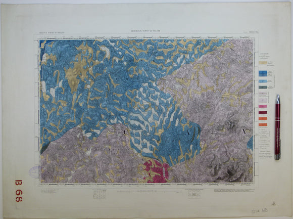
Ireland sheet 68, Cavan, 1” scale. 1878. First edition. Covers Killashandra and Belturret. Base map 1875. Hand-coloured. Geological Survey of Ireland.
Ireland sheet 69, Cootehill, 1” scale. 1901. Covers Stradose, Shercock. Base map 1876. Coloured 1904. Hand-coloured. Geological Survey of Ireland.
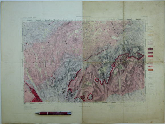
Ireland sheet 70, Dundalk, 1” scale. 1901. Covers Carrickmacross, Crossmaglen. Base map 1874. Coloured 1910. Hand-coloured. Geological Survey of Ireland.
Ireland sheet 71, Carlingford, 1” scale. 1901. Covers Carlingford Lock, Kilkeel. Base map 1874. Coloured 1902. Hand-coloured. Geological Survey of Ireland.
Ireland sheet 71, Carlingford, 1” scale. 1901. Covers Carlingford Lock, Kilkeel. Base map 1874. Hand-coloured. Geological Survey of Ireland.
Ireland sheet 72, untitled – Wreck Port, 1” scale. 1901. 99% sea. Base map not dated. Coloured 1904. Hand-coloured. Geological Survey of Ireland.
Ireland sheet 75, Castlebar, 1” scale. 1870. First edition. Base map not taped. Coloured 1904. Hand-coloured. Geological Survey of Ireland.
Ireland sheet 76, Ballaghaderren, 1” scale. 1874. First edition. Covers Kilkelly, Kiltamagh. Base map not dated. Hand-coloured. Geological Survey of Ireland.
Ireland sheet 77, Elphin, 1” scale. 1873. First edition. Covers Frenchpark. Base map not dated.. Hand-coloured. Geological Survey of Ireland.
Ireland sheet 78, Strokestown, 1” scale. 1872. First edition. Covers Lamestown, Mohill, Drumlish. Base map not dated. Hand-coloured. Geological Survey of Ireland.
Ireland sheet 79, Granard, 1” scale. 1901. Covers Arvagh, Loughs Sheelin and Gowna. Base map not dated. Hand-coloured. Geological Survey of Ireland.
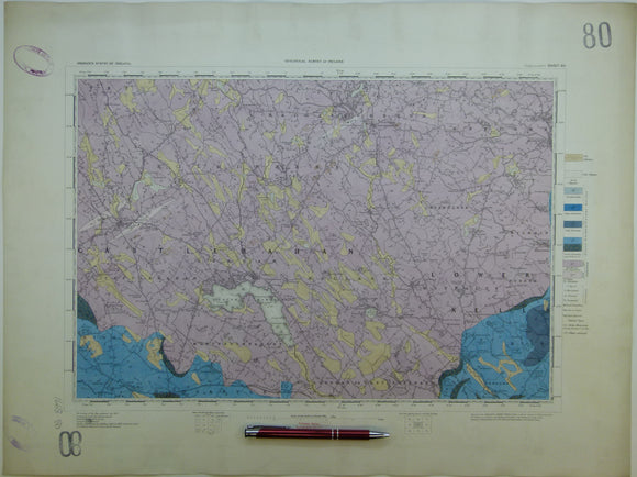
Ireland sheet 80, Ballyjamesduff, 1” scale. 1900. Covers Virginia, Bailieborough. Base map not dated. Hand-coloured. Geological Survey of Ireland.
Ireland sheet 81, Ardee, 1” scale. 1901. Base map not dated. Coloured 1905. Hand-coloured. Geological Survey of Ireland.
Ireland sheet 82, Clogher, 1” scale. 1869. First edition. 75% sea. Base map not dated. Hand-coloured. Geological Survey of Ireland.
Ireland sheet 85, Ballinrobe, 1” scale. 1872. First edition. Covers Loughs Carra and Mask. Base map 1908. Hand-coloured. Geological Survey of Ireland.
Ireland sheet 86, Clare, 1” scale. 1868. First edition. Covers Ballinlough, Dunmore. Base map not dated. Hand-coloured. Geological Survey of Ireland.
Ireland sheet 88, Longford, 1” scale. 1867. First edition. Covers Lanesborough. Base map undated. Hand-coloured. Geological Survey of Ireland.