Free UK postage
Lyell, Charles (1867-68), Principles of Geology or the Modern Changes of the Earth and its inhabitants, 1867-68. John Murray.
Lyell, Charles, (1865). Elements of Geology, or the Ancient Changes of the Earth and its Inhabitants as illustrated by Geological Monuments. John Murray.
Lyell, Charles, 1838. Elements of Geology. London: John Murray. First edition. John Murray.
Macculloch, John (1819). ‘Geological Map] Rum, Egg, Muck’, extract from A Description of the Western Islands of Scotland,. Constable and Co.
Macculloch, John (1819). ‘[Geological Map of the Islands of] Mull, Iona, Staffa’, extract from A Description of the Western Islands of Scotland. Constable and Co.
Macculloch, John (1819). ‘[Geological Maps of the Islands of] Bute and Cumbray, and of Giga and Cara ’, extract from A Description of the Western Islands of Scotland,. Constable and Co.
Macculloch, John (1819). ‘[Geological Maps of the Islands of] Staffa, St. Kilda’, extract from A Description of the Western Islands of Scotland,. Constable and Co.
Macculloch, John (1819). ‘[Geological Map] Kerrera, Seil, Lunga, Scarba, Garveloch’, extract from A Description of the Western Islands of Scotland. Constable and Co.
Macculloch, John. 1821. A Geological Classification of Rocks, with Descriptive Synopses of the Species and Varieties. Longman et al.
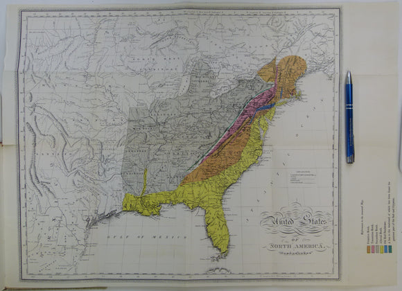
Maclure, William (1817). Observations on the Geology of the United States of America; A 1962 REPRODUCTION. Werner Fritsch.
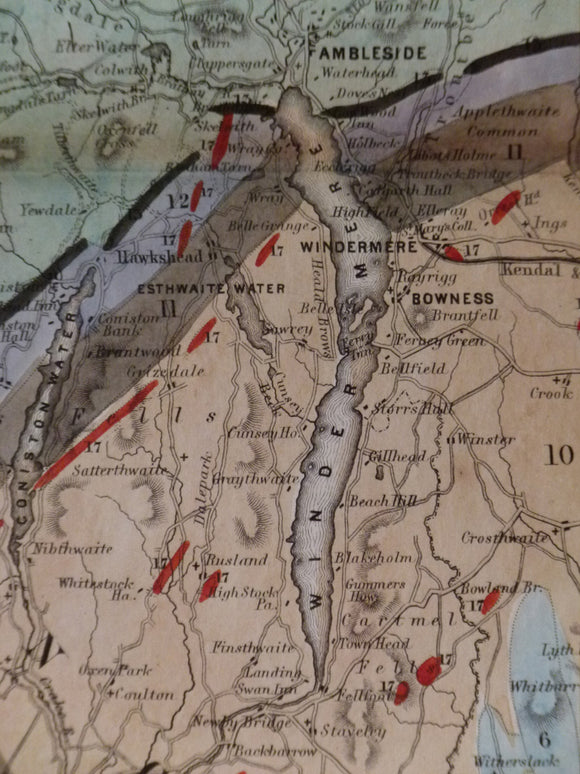
Map of the English Lakes and adjoining Country, Geologically Coloured, 1855. Ruthven, John.
Map of the Geology and Contours of London and its Environs. R. W. Mylne's 1856 map reproduced in 1993. London Topographic Society.
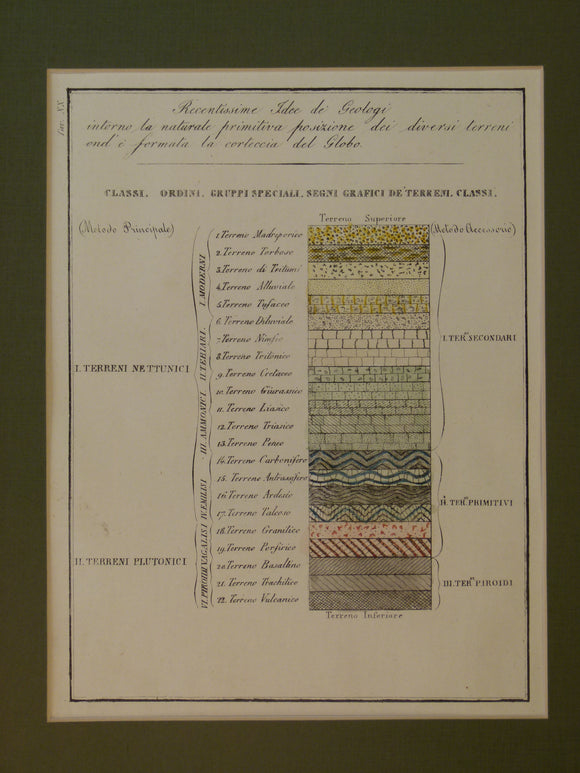
Marmocchi. 1842. Schematic geological column. ‘Recentisssime Idee de Geologi intorno
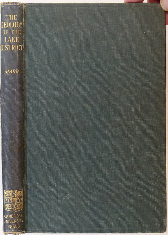
Marr, J.E. (1916). The Geology of the Lake District and the Scenery as Influenced by the Geological Structure. Cambridge University Press. Cambridge University Press.
Maw, George, 1874. Section across Algeria from Algiers to l’Aghouat, Sahara, in ‘Geological Notes on a Journey from Algiers [across Atlas Mountains] to the Sahara. Geological Society of London.
Memoirs of the Geological Survey of GB, v1, 1846. incl. De la Beche, On the Formation of the Rocks of South Wales & SW England. Geological Survey of England & Wales.
Memoirs of the Geological Survey of GB, v1, 1846. incl. On the Denudation of South Wales and the Adjacent Counties of England. Geological Survey of England & Wales.
Memoirs of the Geological Survey of GB, v1, 1846. includes 'Formation of the Rocks of South Wales and South Western England'
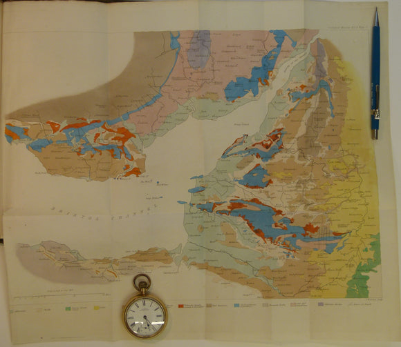
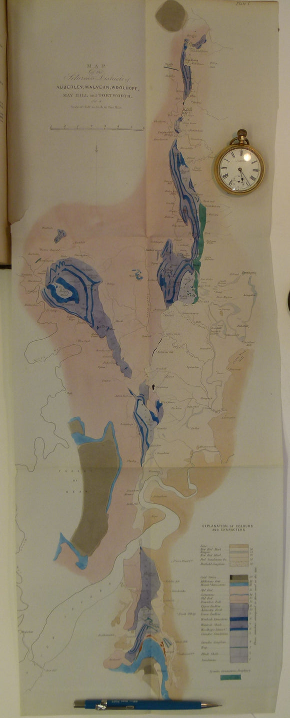
Memoirs of the Geological Survey of GB, v2, pt1, 1848. Incl. J.Phillips, The Malvern Hills. Geological Survey of England & Wales.
Memoirs of the Geological Survey of GB, v2, pt2, 1848. incl. De la Beche on the Coals suited to the Steam Navy. Geological Survey of England & Wales.
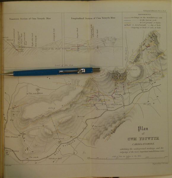
Memoirs of the Geological Survey of GB, v2, pt2, 1848. Incl. On the Mining District of Cardiganshire and Montgomeryshire. Geological Survey of England & Wales.
Memoirs of the Geological Survey of GB, v3, 1881. 2nd edition. ‘The Geology of North Wales’. Geological Survey of England & Wales.
Memoirs of the Geological Survey of GB, v3, 1881.2nd edition.‘The Geology of North Wales’. Geological Survey of England and Wales.
Miller, Hugh (1859). Sketch-Book of Popular Geology; being a Series of Lectures Delivered before the Philosophical Institution of Edinburgh. Thomas Constable.


![Macculloch, John (1819). ‘Geological Map] Rum, Egg, Muck’, extract from A Description of the Western Islands of Scotland,](http://geolmaps.com/cdn/shop/products/RumEggMuck_1_{width}x.jpg?v=1652358140)
![Macculloch, John (1819). ‘Geological Map] Rum, Egg, Muck’, extract from A Description of the Western Islands of Scotland,](http://geolmaps.com/cdn/shop/products/RumEggMuck_1_580x.jpg?v=1652358140)
![Macculloch, John (1819). ‘[Geological Map of the Islands of] Mull, Iona, Staffa’, extract from A Description of the Western Islands of Scotland](http://geolmaps.com/cdn/shop/products/MullIonaetal1_{width}x.jpg?v=1652358353)
![Macculloch, John (1819). ‘[Geological Map of the Islands of] Mull, Iona, Staffa’, extract from A Description of the Western Islands of Scotland](http://geolmaps.com/cdn/shop/products/MullIonaetal1_580x.jpg?v=1652358353)
![Macculloch, John (1819). ‘[Geological Maps of the Islands of] Bute and Cumbray, and of Giga and Cara ’, extract from A Description of the Western Islands of Scotland,](http://geolmaps.com/cdn/shop/products/ButeGigha_1_{width}x.jpg?v=1652358884)
![Macculloch, John (1819). ‘[Geological Maps of the Islands of] Bute and Cumbray, and of Giga and Cara ’, extract from A Description of the Western Islands of Scotland,](http://geolmaps.com/cdn/shop/products/ButeGigha_1_580x.jpg?v=1652358884)
![Macculloch, John (1819). ‘[Geological Maps of the Islands of] Staffa, St. Kilda’, extract from A Description of the Western Islands of Scotland,](http://geolmaps.com/cdn/shop/products/StaffaStKilda1_{width}x.jpg?v=1652358483)
![Macculloch, John (1819). ‘[Geological Maps of the Islands of] Staffa, St. Kilda’, extract from A Description of the Western Islands of Scotland,](http://geolmaps.com/cdn/shop/products/StaffaStKilda1_580x.jpg?v=1652358483)
![Macculloch, John (1819). ‘[Geological Map] Kerrera, Seil, Lunga, Scarba, Garveloch’, extract from A Description of the Western Islands of Scotland](http://geolmaps.com/cdn/shop/products/Kerrera3_{width}x.jpg?v=1652358764)
![Macculloch, John (1819). ‘[Geological Map] Kerrera, Seil, Lunga, Scarba, Garveloch’, extract from A Description of the Western Islands of Scotland](http://geolmaps.com/cdn/shop/products/Kerrera3_580x.jpg?v=1652358764)


![Maw, George, 1874. Section across Algeria from Algiers to l’Aghouat, Sahara, in ‘Geological Notes on a Journey from Algiers [across Atlas Mountains] to the Sahara](http://geolmaps.com/cdn/shop/products/Algeria_2_{width}x.JPG?v=1547575036)
![Maw, George, 1874. Section across Algeria from Algiers to l’Aghouat, Sahara, in ‘Geological Notes on a Journey from Algiers [across Atlas Mountains] to the Sahara](http://geolmaps.com/cdn/shop/products/Algeria_2_580x.JPG?v=1547575036)